This cul-de-sac, which goes just about 375 feet northwest from SW Donovan Street between 41st Avenue SW and 42nd Avenue SW, was created as part of the Robert E. Thomas Addition in 1959. Its original name was Fauntlee Place SW, but this was changed in 1963, presumably to avoid confusion with the nearby Fauntlee Crest SW. (No confusion was anticipated with the nearby Vashon Place SW, it seems.) Like Vashon Place, it is named after Vashon Island, located 4 miles to the southwest, across Puget Sound. The island itself was named for Royal Navy Admiral James Vashon by his friend, Royal Navy Captain George Vancouver, in 1792.
Unlike Vashon Place SW, Vashon View SW actually has a view of Vashon Island, though not the one you see below!
Born and raised in Seattle, Benjamin Donguk Lukoff had his interest in local history kindled at the age of six, when his father bought him settler granddaughter Sophie Frye Bass’s Pig-Tail Days in Old Seattle at the gift shop of the Museum of History and Industry. He studied English, Russian, and linguistics at the University of Washington, and went on to earn his master’s in English linguistics from University College London. His book of rephotography, Seattle Then and Now, was published in 2010. An updated version came out in 2015.
Elm Place SW begins at SW California Place and goes 300 feet southeast to SW Maryland Place, paralleling Harbor Avenue SW just over 100 feet to its northeast.
Born and raised in Seattle, Benjamin Donguk Lukoff had his interest in local history kindled at the age of six, when his father bought him settler granddaughter Sophie Frye Bass’s Pig-Tail Days in Old Seattle at the gift shop of the Museum of History and Industry. He studied English, Russian, and linguistics at the University of Washington, and went on to earn his master’s in English linguistics from University College London. His book of rephotography, Seattle Then and Now, was published in 2010. An updated version came out in 2015.
This street is named for Peter Wickstrom (1837–1915), who immigrated to the United States from Sweden in the late 1860s. According to Thomas Ostenson Stine’s Scandinavians on the Pacific, Puget Sound, he lived in St. Paul, Minnesota, and Portland, Oregon, before coming to Seattle. His obituary, which ran in The Seattle Times on January 15, 1915, the day after his death, reads in part:
Peter Wickstrom, well-known pioneer of Seattle and an extensive realty holder, died unexpectedly yesterday afternoon after leaving the dinner table at his residence near Alki Point.… The deceased made his home at “The Old Homestead,” a tract of land not far from Alki Point.… Wickstrom came to this city in 1873 and conducted a hotel prior to the fire of 1889. Subsequent to that time he had not engaged actively in business.
Peter Wickstrom, from his Seattle Times obituary
Wickstrom Place SW begins at 54th Place SW just south of Alki Avenue SW and goes around 500 feet south to a dead end.
The Peter Wickstrom tract in Baist’s 1912 atlas of Seattle
The Peter Wickstrom tract in Kroll’s 1920 atlas of Seattle
Peter Wickstrom’s 7.18-acre tract before and after his death.
Born and raised in Seattle, Benjamin Donguk Lukoff had his interest in local history kindled at the age of six, when his father bought him settler granddaughter Sophie Frye Bass’s Pig-Tail Days in Old Seattle at the gift shop of the Museum of History and Industry. He studied English, Russian, and linguistics at the University of Washington, and went on to earn his master’s in English linguistics from University College London. His book of rephotography, Seattle Then and Now, was published in 2010. An updated version came out in 2015.
Born and raised in Seattle, Benjamin Donguk Lukoff had his interest in local history kindled at the age of six, when his father bought him settler granddaughter Sophie Frye Bass’s Pig-Tail Days in Old Seattle at the gift shop of the Museum of History and Industry. He studied English, Russian, and linguistics at the University of Washington, and went on to earn his master’s in English linguistics from University College London. His book of rephotography, Seattle Then and Now, was published in 2010. An updated version came out in 2015.
Matilda and Nelson Chilberg. Her photo is from the July 17, 1927, issue of the The Seattle Times; his is from the December 15, 1928, issue of the Seattle Post-Intelligencer.
Chilberg Avenue SW begins at 59th Avenue SW and SW Carroll Street and goes ⅕ of a mile southeast to SW Genessee Street just east of Beach Drive SW at the Emma Schmitz Memorial Overlook and Me-Kwa-Mooks Park.
Born and raised in Seattle, Benjamin Donguk Lukoff had his interest in local history kindled at the age of six, when his father bought him settler granddaughter Sophie Frye Bass’s Pig-Tail Days in Old Seattle at the gift shop of the Museum of History and Industry. He studied English, Russian, and linguistics at the University of Washington, and went on to earn his master’s in English linguistics from University College London. His book of rephotography, Seattle Then and Now, was published in 2010. An updated version came out in 2015.
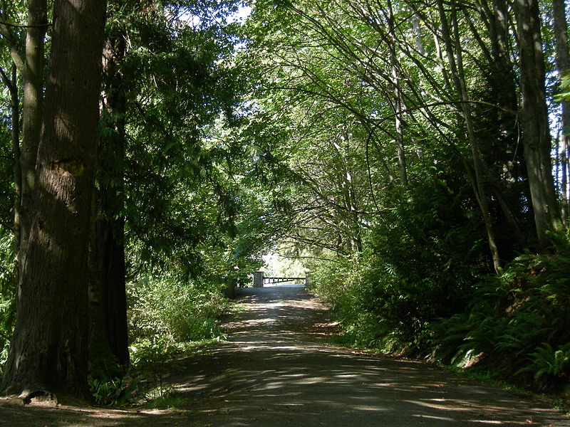
This West Seattle street is really more of a footpath, being narrow, unpaved, and closed to motor vehicles. The public right-of-way runs about 450 feet northwest from Bonair Drive SW as it descends through the Duwamish Head Greenbelt from Sunset Avenue SW to Alki Avenue SW, and the path continues for some 1,150 feet more through property owned by the parks department.
Clarmar Place SW was created in 1941 as part of the plat of Clarmar Crags, which name appears to be a combination of Clara Coumbe (died 1975?), landowner, and mar, for its location above Elliott Bay and Puget Sound.
Born and raised in Seattle, Benjamin Donguk Lukoff had his interest in local history kindled at the age of six, when his father bought him settler granddaughter Sophie Frye Bass’s Pig-Tail Days in Old Seattle at the gift shop of the Museum of History and Industry. He studied English, Russian, and linguistics at the University of Washington, and went on to earn his master’s in English linguistics from University College London. His book of rephotography, Seattle Then and Now, was published in 2010. An updated version came out in 2015.
I haven’t posted in a couple of weeks because I’ve been in Spokane, visiting my wife’s family for the holidays and attending the memorial service of my sister-in-law, may her memory be for a blessing. Since there is no Emily Street in Seattle, why not return, then, with a post on Spokane Street?
S Spokane Street looking west from 1st Avenue South, July 5, 2013. Photograph by Flickr user Curtis Cronn, licensed under Creative Commons Attribution-NonCommercial-NoDerivs 2.0 Generic. The barcodes on the support columns for the Spokane Street Viaduct was, in the words of the artwork’s creators, Claudia Reisenberger and Franka Diehnelt, intended “to ‘label’ the many layers that constitute SoDo’s history”; the word visible at upper left, ‘slóóweehL’, is a Lushootseed-language word that, according to Coll Thrush, author of Native Seattle: Histories from the Crossing-Over Place, “refers to channels, or ‘canoe-passes’, in the grassy marsh through which canoes can be pushed to effect a shortcut,” and was a Duwamish place name referring to what is now approximately 4th Avenue S and S Spokane Street. (Incidentally, this is the same word rendered as sluʔwiɫ in the IPA-based Lushootseed alphabet, which was also used as a name for what is now University Village, and is now the official name of a street on the University of Washington campus.)
Spokane Street appears to have been created in 1895 as part of the Seattle Tide Lands plat. Streets in this plat that were not extensions of already existing ones, such as Commercial Street, were named after letters of the alphabet, American cities, American states, prominent local politicians, and places in Washington. The letters of the alphabet and the American cities appear in alphabetical order, but the states appear neither in alphabetical nor geographic order, and the places in Washington do not appear to be in any order whatsoever (except that a number beginning with Q are physically clustered together). They are as follows, listed alphabetically:
(I leave out West Point Avenue [which still exists, but only as a paper street] and Seattle Boulevard [now Airport Way S and Diagonal Avenue S] because the former was named for its proximity to West Point and the latter, it seems, for its prominence.)
It isn’t a list entirely composed of cities, islands, peninsulas, lakes, or rivers… the only things I notice are ⅔ of them are in Western Washington, with Chelan, Klickitat, and Wenatchee being in Central Washington and Spokane being in Eastern Washington; plus half the Western Washington locations (those beginning with Q) are on the Olympic Peninsula. It seems what is today Spokane Street could just as easily have been something else, and what is today such a prominent street wasn’t purposefully named after what was then the state’s third largest city (today, it ranks second).
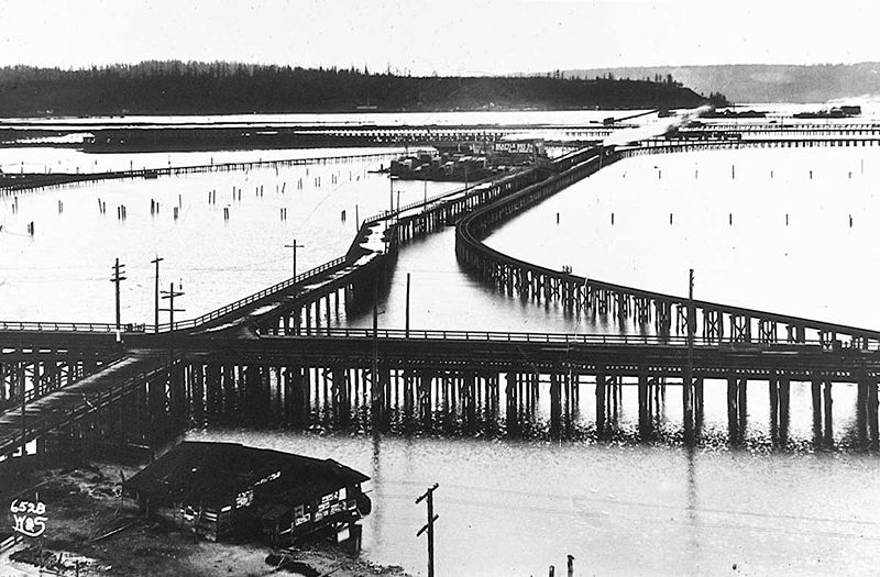
Trestles over the Elliott Bay tideflats, 1905. Photograph by Ira Webster and Nelson Stevens. According to the Wikimedia Commons entry for a similar photograph, the trestle in the foreground, running right to left (north to south), is today’s Airport Way S; the parallel trestle in the distance is 4th Avenue S; and running perpendicular from lower left to upper right (east to west, toward West Seattle) is S Spokane Street. The Seattle Box Company plant is visible at 4th and Spokane.
A modern view of the Industrial District, Harbor Island, and West Seattle from above Beacon Hill, August 15, 2010. Photograph by Flickr user J Brew, licensed under Creative Commons Attribution-ShareAlike 2.0 Generic. The freeway in the foreground, running right to left (north to south), is Interstate 5. Airport Way S is visible just west of the freeway. The Spokane Street Viaduct and West Seattle Bridge can be seen at left heading from Beacon Hill to West Seattle. 4th Avenue S is still a major arterial, though it isn’t nearly as prominent in this photograph as the one taken 105 years earlier.
Today, SW Spokane Street begins in West Seattle at Beach Drive SW, ½ a mile southeast of Alki Point, then goes nearly ½ a mile east to Schmitz Park, the block between 61st Avenue SW and 60th Avenue SW being a stairway. It resumes on the other side of the park at 51st Avenue SW and goes another ½ mile to 42nd Avenue SW. After a few interrupted segments between 35th Avenue SW and 30th Avenue SW, including another stairway, it begins again in earnest at Harbor Avenue SW and SW Admiral Way. From here it goes a full 2¼ miles east to Airport Way S, crossing the Duwamish Waterway and Harbor Island on the Spokane Street Bridge, and for this entire length runs either underneath or in the shadow of the West Seattle Bridge or the Spokane Street Viaduct, the latter of which leads to S Columbian Way on Beacon Hill.
After a short segment between Hahn Place S and 13th Avenue S, S Spokane Street begins again at 14th Avenue S and S Columbian Way and goes ⅔ of a mile east to 24th Avenue S. With the exception of an even shorter segment hanging off 25th Avenue S north of the Cheasty Boulevard greenspace, it next appears in Mount Baker, where it runs for two blocks between 33rd Avenue S and 35th Avenue S (part of this being stairway); then two more blocks between 36th Avenue S and York Road S (featuring another stairway); and two final blocks between 37th Avenue S and Bella Vista Avenue S.
Portion of 1895 plat of Seattle Tide Lands showing Spokane Avenue, now Spokane Street. The visible portion of Seattle Boulevard is now Diagonal Avenue S, and Whatcom Avenue is E Marginal Way S. Portions of Chelan Avenue, Klickitat Avenue, and Duwamish Avenue still exist, as do Oregon Street, Dakota Street, Idaho Street, Colorado Avenue, and Utah Avenue.
Born and raised in Seattle, Benjamin Donguk Lukoff had his interest in local history kindled at the age of six, when his father bought him settler granddaughter Sophie Frye Bass’s Pig-Tail Days in Old Seattle at the gift shop of the Museum of History and Industry. He studied English, Russian, and linguistics at the University of Washington, and went on to earn his master’s in English linguistics from University College London. His book of rephotography, Seattle Then and Now, was published in 2010. An updated version came out in 2015.
I enjoy writing posts on streets like W Commodore Way (I believe I am the first to have accurately identified its namesake), Division Avenue NW (I show that, even though it doesn’t divide anything from anything else today, it once served as Ballard’s eastern city limit for a few blocks), Loyal Avenue NW (I discover that it’s named not for the concept of loyalty, but for a baby girl whose first name was Loyal), and sluʔwiɫ (the University of Washington’s new Lushootseed-language name for Whitman Court). But sometimes I just like knocking something out quickly (I’m looking at you, W View Place and View Avenue NW). Sunset Avenue SW is another one of those. It originated in the 1888 First Plat of West Seattle by the West Seattle Land and Improvement Company, and the name simply refers to the street’s western view of Puget Sound; Vashon, Blake, and Bainbridge Islands; the Kitsap Peninsula; and the Olympic Mountains.
Sunset Avenue SW begins as a stairway at California Avenue SW, just across the street from Hamilton Viewpoint Park. Once the roadway begins up the hill, it goes ⅘ of a mile southwest to a dead end at the College Street Ravine southwest of 50th Avenue SW.
Born and raised in Seattle, Benjamin Donguk Lukoff had his interest in local history kindled at the age of six, when his father bought him settler granddaughter Sophie Frye Bass’s Pig-Tail Days in Old Seattle at the gift shop of the Museum of History and Industry. He studied English, Russian, and linguistics at the University of Washington, and went on to earn his master’s in English linguistics from University College London. His book of rephotography, Seattle Then and Now, was published in 2010. An updated version came out in 2015.
This road, and the park through which it runs, Schmitz Park (or Schmitz Preserve Park), was named for German immmigrants Ferdinand Schmitz (1860–1942) and his wife, Emma Althoff Schmitz (1864–1959). Ferdinand was a banker, city councilman, and parks commissioner. He and Emma donated land — mostly, though not entirely, old-growth forest — to the city in 1908, forming the core (just over 55%) of the present park.
The Schmitzes had four children: Dietrich, Henry, Emma Henrietta, and Ferdinand Jr. A banker, Dietrich (1890–1969) became president of Washington Mutual in 1934 and retired as chairman of the board two years before his death. He was also a member of the Seattle School Board from 1928 (or 1930; sources differ) to 1961. Henry (1892–1965) was president of the University of Washington from 1952 to 1958. Schmitz Hall, the university’s administration building on NE Campus Parkway, was named in his memory in 1970.
The roadway was originally envisioned as a continuation of the West Seattle Parkway, never realized, which would have connected Alki Beach to Lake Washington via a series of parkways. The built section is instead a short road that provided the only automobile entry to Schmitz Park, extending through an allée of trees and terminating at a pergola and shelterhouse.
Map of proposed West Seattle Parkway, cropped from a 1928 map showing both existing (red) and proposed (red hatched) park features. Schmitz Park and Boulevard are at upper left. Courtesy of the Seattle Municipal Archives, Identifier 2333.
The portion between 59th Avenue SW and 58th Avenue SW in front of Alki Elementary School having been closed in 1949, Schmitz Boulevard today begins at 58th Avenue SW and SW Stevens Street and goes not quite half a mile east, then southeast, then north, to SW Admiral Way and SW Stevens Street. It is closed to automobile traffic.
Emma Schmitz
Ferdinand Schmitz
Emma and Ferdinand Schmitz. Her photo is from the December 24, 1959, issue of the Seattle Post-Intelligencer (she had died December 23); his is from the August 23, 1942, issue of The Seattle Times (he had died August 21).
Born and raised in Seattle, Benjamin Donguk Lukoff had his interest in local history kindled at the age of six, when his father bought him settler granddaughter Sophie Frye Bass’s Pig-Tail Days in Old Seattle at the gift shop of the Museum of History and Industry. He studied English, Russian, and linguistics at the University of Washington, and went on to earn his master’s in English linguistics from University College London. His book of rephotography, Seattle Then and Now, was published in 2010. An updated version came out in 2015.
Puget Boulevard is a curious street, for a number of reasons:
The paved portions are only a few blocks long — hardly comparable to, say, Lake Washington Boulevard or Magnolia Boulevard;
Both east–west and north–south portions are called Puget Boulevard SW, contrary to the rule that directional designations precede street names for east–west streets (this is why Lake Washington Boulevard E becomes E Lake Washington Boulevard when it curves west on its approach to Montlake Boulevard E);
Despite its name, it has no view of Puget Sound, sitting as it does in the Longfellow Creek valley in the Delridge neighborhood of West Seattle;
And, as it turns out, it isn’t even named for Puget Sound, as might be expected, but rather for the Puget Mill Company (later part of Pope & Talbot and today part of Rayonier).
“A rugged tract of logged-off land south of Pigeon Point and Youngstown in the large unplatted area” (20.5 acres — this became Puget Park); and
“A strip of land 160 feet in width extending from Sixteenth Avenue Southwest and Edmonds Street (sic) to Thirty-fifth Avenue Southwest and Genessee Street, a distance of 8,500 feet, and comprising an area of about fifteen acres for parkway purposes. Under the conditions of this gift improvement work must be undertaken within five years. This acquisition forms an important link in the contemplated boulevard to West Seattle.”
This strip is today’s Puget Boulevard SW. Two things become apparent when looking at the King County Parcel Viewer map of West Seattle:
Map of Puget Boulevard, from King County Parcel Viewer
Once past the present site of West Seattle Stadium, the “contemplated boulevard to West Seattle” was to have run, as the Friends of Seattle’s Olmsted Parks puts it,
[Across] California Avenue a few blocks north of [the] present-day Alaska Junction, at that time part of the “Boston Subdivision.” It would have then headed northwest and down a ravine, eventually turning southwest to terminate at Alki Point.
Map of proposed West Seattle Parkway, cropped from a 1928 map showing both existing (red) and proposed (red hatched) park features. Puget Park and Boulevard are at lower right. Courtesy of the Seattle Municipal Archives, Identifier 2333.
Returning to the question of the name — the Puget Mill Company was, of course, named after Puget Sound, which itself was named in 1792 by Captain George Vancouver of HMS Discovery for Lieutenant Peter Puget (1765–1822).
Today, the paved portion of Puget Boulevard SW begins at 23rd Avenue SW, about 1⁄10 of a mile north of SW Hudson Street, and goes ⅕ of a mile south to a dead end. After a very short section — not more than 150 feet long — east of Delridge Way SW, which serves as a driveway for a complex of townhouses, it resumes west of a foot path off Delridge and goes about 1⁄10 of a mile west to 26th Avenue SW. Along this stretch, there are houses to the north and the Delridge P-Patch and Puget Boulevard Commons to the south.
Born and raised in Seattle, Benjamin Donguk Lukoff had his interest in local history kindled at the age of six, when his father bought him settler granddaughter Sophie Frye Bass’s Pig-Tail Days in Old Seattle at the gift shop of the Museum of History and Industry. He studied English, Russian, and linguistics at the University of Washington, and went on to earn his master’s in English linguistics from University College London. His book of rephotography, Seattle Then and Now, was published in 2010. An updated version came out in 2015.
This street, which was created in 1936, was named after Alki Point. Alki Avenue SW runs southwest from Duwamish Head to about 450 feet northeast of the point, where it turns south for a block and then becomes Beach Drive SW; Point Place continues another 200 or so feet toward Alki Point.
Arthur Armstrong Denny (1822–1899), the leader of the Denny Party that landed at Alki Point on November 13, 1851, helped build this cabin. Most of the party moved to what is now Pioneer Square the next spring. Photograph by Frank LaRoche, no date (though no later than 1891, when the cabin, shown here in ruins, was demolished).
Aerial view of West Seattle, March 17, 2009. Alki Point is in the lower-left-hand (west) corner; Duwamish Head is in the upper-left-hand (north) corner. The green spaces in the foreground, from left to right (north to south), are the Duwamish Head Greenbelt, Schmitz Preserve Park, and Mee-Kwa-Mooks Park. Elliott Bay lies north and east of Alki Point; the rest of the water is Puget Sound. Public domain photograph by Dcoetzee, Wikimedia Commons.
Born and raised in Seattle, Benjamin Donguk Lukoff had his interest in local history kindled at the age of six, when his father bought him settler granddaughter Sophie Frye Bass’s Pig-Tail Days in Old Seattle at the gift shop of the Museum of History and Industry. He studied English, Russian, and linguistics at the University of Washington, and went on to earn his master’s in English linguistics from University College London. His book of rephotography, Seattle Then and Now, was published in 2010. An updated version came out in 2015.
The settlement at Alki Point established by the Denny Party in 1851 was originally named New York. By a process that is not entirely clear, the name became New York–Alki, and then just Alki. Alki means ‘by and by’ or ‘someday’ in Chinook Jargon, the implication being that the settlement might rival New York… someday. Charles C. Terry officially applied the Alki name to the town plat he filed in 1853, and the point, street, and neighborhood were all named after it.
In the introduction to her 1937 book, Pig-Tail Days in Old Seattle, Sophie Frye Bass writes:
Please everyone, pronounce Alki as the Indians did, as if it were spelled “Alkey.”
Hardly anyone does this anymore — in fact I don’t think I’ve ever heard someone say /ælkiː/ in all seriousness when talking about West Seattle. /ælkaɪ/ is by far the preferred pronunciation, as shown by this informal Twitter poll I ran:
Note: On July 10, 2024, I began converting embedded tweets on this website to screenshots because of issues with how they were integrating with WordPress, which began not too long after Elon Musk purchased Twitter and changed its name to X.
Louis Miranda: Suqmish Elder teaches Chinook Wawa on YouTubeBirthplace of Seattle monument, 1926. Originally dedicated in 1905 on the 54th anniversary of the landing of the Denny Party at Alki Point, it reads “At this place on 13 November 1851 there landed from the Schooner Exact Captain Folger [and] the little colony which developed into the City of Seattle.” It was rededicated, with a new foundation, on September 4, 1926 (likely the date of this photograph). A stone from near Plymouth Rock, Massachusetts, was put in the foundation, and the new plaque reads “From Plymouth Rock to Alki Point: Honoring pioneers on the American shores of the Atlantic and Pacific Oceans, the above stone was brought from Plymouth Rock by the First Transcontinental Motorized Caravan, managed by James H. Brown, and endorsed by the American Automobile Association. This tablet was furnished by the Automobile Club of Washington. The unveiling ceremonies on September 4, 1926, was participated in by officers and citizens of. the City of Seattle, the County of King and the State of Washington.” Courtesy of the Seattle Municipal Archives, Identifier 46980
Born and raised in Seattle, Benjamin Donguk Lukoff had his interest in local history kindled at the age of six, when his father bought him settler granddaughter Sophie Frye Bass’s Pig-Tail Days in Old Seattle at the gift shop of the Museum of History and Industry. He studied English, Russian, and linguistics at the University of Washington, and went on to earn his master’s in English linguistics from University College London. His book of rephotography, Seattle Then and Now, was published in 2010. An updated version came out in 2015.
Like Harbor Avenue SW, Beach Drive SW was once part of Alki Avenue SW. It became Beach Drive sometime between 1912 and 1920. In contrast to Alki and Harbor Avenues, most of Beach Drive’s beaches are private, though there is a long public stretch at the Emma Schmitz Memorial Outlook, as well as Lowman Beach Park at the south end.
Born and raised in Seattle, Benjamin Donguk Lukoff had his interest in local history kindled at the age of six, when his father bought him settler granddaughter Sophie Frye Bass’s Pig-Tail Days in Old Seattle at the gift shop of the Museum of History and Industry. He studied English, Russian, and linguistics at the University of Washington, and went on to earn his master’s in English linguistics from University College London. His book of rephotography, Seattle Then and Now, was published in 2010. An updated version came out in 2015.
As noted in Alaskan Way, Harbor Avenue SW was once part of Railroad Avenue. When the Elliott Bay tidelands were platted in 1895, Railroad Avenue stretched from (using current landmarks) the Magnolia Bridge along the waterfront to the Industrial District, then across Harbor Island to West Seattle, ending southwest of Duwamish Head. In 1907 the West Seattle portion was renamed Alki Avenue, and sometime between 1912 and 1920 it was given its current name.
Looking northwest up what is now Harbor Avenue SW toward Duwamish Head, April 1902
Today, Harbor Avenue SW begins at SW Avalon Way and SW Spokane Street at the west end of the West Seattle Bridge and goes 1¾ miles northwest to Duwamish Head, where it becomes Alki Avenue SW.
Born and raised in Seattle, Benjamin Donguk Lukoff had his interest in local history kindled at the age of six, when his father bought him settler granddaughter Sophie Frye Bass’s Pig-Tail Days in Old Seattle at the gift shop of the Museum of History and Industry. He studied English, Russian, and linguistics at the University of Washington, and went on to earn his master’s in English linguistics from University College London. His book of rephotography, Seattle Then and Now, was published in 2010. An updated version came out in 2015.
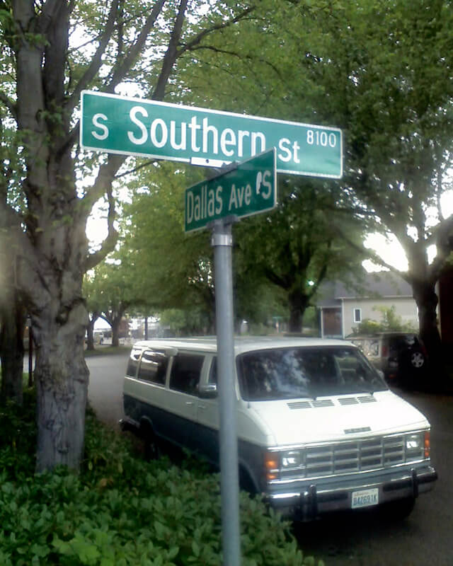
Portion of River Park addition showing Southern Avenue (now Southern Street)
S Southern Street begins just east of 12th Avenue S on the west bank of the Duwamish Waterway, and goes ½ a mile to just west of 7th Avenue S, where it is blocked by Washington State Route 99 (W Marginal Way S). (Its first tenth of a mile is within unincorporated King County as part of the “Sliver by the River.”) It begins again in West Seattle as SW Southern Street at 35th Avenue SW, and goes ⅗ of a mile to 44th Avenue SW.
Born and raised in Seattle, Benjamin Donguk Lukoff had his interest in local history kindled at the age of six, when his father bought him settler granddaughter Sophie Frye Bass’s Pig-Tail Days in Old Seattle at the gift shop of the Museum of History and Industry. He studied English, Russian, and linguistics at the University of Washington, and went on to earn his master’s in English linguistics from University College London. His book of rephotography, Seattle Then and Now, was published in 2010. An updated version came out in 2015.
This street was named for Walter Graham (1828–1919), who came to Seattle in 1853. Three years later, he married Eliza Mercer, second daughter of Thomas Mercer (Mercer Street, Mercer Island), though she unfortunately died six years later. With his third wife, Elizabeth Crammond (or Crommon), he had a daughter, Nellie, who later married David Thomas Denny II, son of early settler David Thomas Denny (Denny Way). Graham’s brother, David, came to Seattle four years after his brother, and was one of the city’s first schoolteachers. He ended up marrying Eliza Mercer’s sister, Susannah.
Graham sold some of his southeast Seattle land in 1865 to Everett Smith, who filed the plat of Brighton Beach in 1890 on which what was then Graham Avenue appeared. He once owned what is today Seward Park on Bailey Peninsula, which was previously known as Graham’s Peninsula.
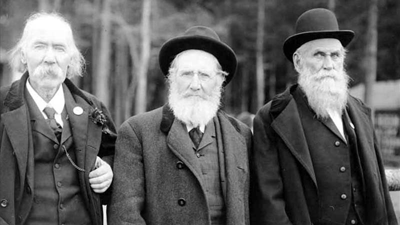
He was present at the Battle of Seattle in 1856, and is pictured below with fellow survivors Ira Woodin and Carson D. Boren (Boren Avenue).
Ira Woodin, Carson Boren, and Walter Graham at Alki Point, November 3, 1905
S Graham Street begins in the east at Wilson Avenue S and goes 2⅒ miles west to Swift Avenue S and 20th Avenue S, just east of Interstate 5. After a short segment between Corgiat Drive S and 16th Avenue S just west of the freeway, it next appears in West Seattle. Betwen 16th Avenue SW and 22nd Avenue SW, it alternates between roadway, stairway, and pathway, and there is a similar situation between 25th Avenue SW at Delridge Way SW and High Point Drive SW at Bataan Park. SW Graham Street begins again at High Point Drive SW and SW Raymond Street and goes 1¼ miles to its end at 50th Avenue SW,
Born and raised in Seattle, Benjamin Donguk Lukoff had his interest in local history kindled at the age of six, when his father bought him settler granddaughter Sophie Frye Bass’s Pig-Tail Days in Old Seattle at the gift shop of the Museum of History and Industry. He studied English, Russian, and linguistics at the University of Washington, and went on to earn his master’s in English linguistics from University College London. His book of rephotography, Seattle Then and Now, was published in 2010. An updated version came out in 2015.
I initially posted that this street was named for Judge Edward Lander (1816–1907), chief justice of the territorial supreme court from 1853 to 1857. In 1855, he, along with Charles Terry, bought Carson Boren’s downtown land claim for $500. They subsequently donated two acres of land, along with Arthur Denny, who donated eight, to form the first campus of the University of Washington, which opened in 1861. The university owns the Metropolitan Tract to this day, though it moved to its present location in 1895. Lander’s name also appears on Lander Hall, a UW dormitory on NE Campus Parkway.
Edward Lander was a political foe of and was jailed by Stevens [then governor of Washington Territory] when Lander opposed Stevens’ 1855 martial law declaration and actions. Stevens and Edward Lander maintained a widely recognized lifelong enmity. It is unlikely that Hanford would have memorialized this hostility.
Frederick W. Lander
SW Lander Street begins at 59th Avenue SW in the Alki neighborhood of West Seattle, and goes ⅕ of a mile to 55th Avenue SW. It resumes just to the south at S Lander Place and goes a further ⅛ of a mile to SW Admiral Way. Picking up again at 50th Avenue SW, it makes it ½ a mile to Walnut Avenue SW before being interrupted again, as happens to so many West Seattle streets because of the varying topography. There is a final ¼-mile stretch in West Seattle from 39th Avenue SW to 36th Avenue SW, then a very short segment on Harbor Island before S Lander Street resumes in the Industrial District at Colorado Avenue S and goes ¾ of a mile east to Airport Way S. On Beacon Hill, Lander begins just west of 13th Avenue S and goes ⅔ of a mile to just past 23rd Avenue S, including the block-long stretch that is now known as S Roberto Maestas Festival Street. Lander begins again at 30th Avenue S in Mount Baker and goes a final four blocks to 34th Avenue S.
Born and raised in Seattle, Benjamin Donguk Lukoff had his interest in local history kindled at the age of six, when his father bought him settler granddaughter Sophie Frye Bass’s Pig-Tail Days in Old Seattle at the gift shop of the Museum of History and Industry. He studied English, Russian, and linguistics at the University of Washington, and went on to earn his master’s in English linguistics from University College London. His book of rephotography, Seattle Then and Now, was published in 2010. An updated version came out in 2015.
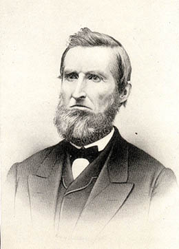
This street is named for Edward Hanford (1807–1884) and his wife, Abigail Jane Holgate (1824–1905), who left Iowa in the early 1850s to settle adjacent to Abigail’s brother, John (namesake of S Holgate Street), on what is today known as Beacon Hill but was known from then until the early 1890s as Holgate and Hanford Hill. Edward and his family were loggers, then orchardists, and unlike John Holgate, he went on to develop his donation claim.
The Hanfords’ son Clarence (1857–1920) founded, with James D. Lowman, the Lowman & Hanford Stationery and Printing Company in 1885. The firm went out of business in the 1960s, but their Pioneer Square building still, the last time I drove by, had a sign painted on it reading “Seattle’s Oldest Retail Company,” which it very well might have been when it closed. Their son Thaddeus (1847–1892) was for a time the owner of the Daily Intelligencer newspaper, predecessor of the Seattle Post-Intelligencer. And their son Cornelius (1849–1926), a federal judge from 1890 to 1912, was earlier a territorial legislator, Seattle city attorney, and chief justice of the Washington Supreme Court. He is the namesake of Hanford, Washington, and by extension the Hanford Site, which produced the plutonium used in the first nuclear explosion and the bombing of Nagasaki. He was also the author of Seattle and Environs, 1852-1924.
Edward Hanford
SW Hanford Street begins in West Seattle at SW Admiral Way and 59th Avenue SW and goes ¼ mile east to Schmitz Preserve Park at 56th Avenue SW. It begins again at 51st Avenue SW and goes nearly a mile east to 36th Avenue SW, becoming a stairway for the half-block east of 46th Avenue SW. After serving as little more than a driveway between SW Admiral Way and Fauntleroy Avenue SW, it next appears as S Hanford Street at E Marginal Way S, where it goes for ⅓ of a mile east to Occidental Avenue S. After a few short segments farther east in the Industrial District, Hanford begins again on Beacon Hill at 12th Avenue S and goes nearly a mile east to Rainier Avenue S, the segment between 25th Avenue S and Morse Avenue S being a stairway. It resumes a few blocks east at 30th Avenue S and finishes up ½ a mile east at Cascadia Avenue S.
Born and raised in Seattle, Benjamin Donguk Lukoff had his interest in local history kindled at the age of six, when his father bought him settler granddaughter Sophie Frye Bass’s Pig-Tail Days in Old Seattle at the gift shop of the Museum of History and Industry. He studied English, Russian, and linguistics at the University of Washington, and went on to earn his master’s in English linguistics from University College London. His book of rephotography, Seattle Then and Now, was published in 2010. An updated version came out in 2015.
This street is named for John Cornelius Holgate (1828–1868). Born in Ohio, he took the Oregon Trail west in 1847 and explored Elliott Bay and the Duwamish River by canoe in the summer of 1850. (The Seattle Times calls him “the first non-Indian of record to have done so.”) He returned to Oregon afterwards, however, and did not settle in what is now Seattle — specifically, Beacon Hill — until 1853, two years after the Denny Party landed at Alki Point. His mother, Elizabeth; brothers, Lemuel and Milton; and sister, Abigail, along with her husband, Edward Hanford (namesakes of S Hanford Street), soon followed. The Hanfords settled on the hill — known thereafter as Holgate and Hanford Hill until the late 1880s — adjacent to Holgate. (Milton was one of three whites to die in the Battle of Seattle in 1856, and was himself the cause of one of those deaths, having earlier shot Jack Drew, a deserting sailor from the USS Decatur, in a “friendly-fire” incident.)
A gold prospector, Holgate left for Idaho in 1863, and died there in 1868, the first casualty of the War Under the Mountain, a conflict between two rival gold mines in the Owyhee Desert, one of which he was part owner. According to Robert L. Deen, writing for True West magazine, there are conflicting accounts of Holgate’s death. The Owyhee Avalanche reported that:
Desperate fighting ensued during the charge…. John C. Holgate… one of the foremost in the advance, was shot in the head, and must have died instantaneously.
The Idaho Tri-Weekly Statesman had a slightly different story:
It appears that J.C. Holgate has been killed, some say assassinated, murdered — not killed in a fight, but shot through the head without provocation.
SW Holgate Street begins in West Seattle just west of 47th Avenue SW and goes ¼ of a mile east to California Avenue SW at Palm Avenue SW. There are two more short segments on the peninsula, between 41st Avenue SW and Arch Avenue SW and between Victoria Avenue SW and Brook Avenue SW. S Holgate Street resumes at Utah Avenue S and goes ¾ of a mile east to an overpass over Interstate 5, where it becomes Beacon Avenue S. There is a one-block stretch between 12th Avenue S and 13th Avenue S on top of the hill, and then Holgate goes a mile from the Beacon Hill Playfield at 14th Avenue S to 31st Avenue S at Colman Park, the half-block east of 16th Avenue S being a stairway and the block between 28th Avenue S and 29th Avenue S being unimproved. There is finally a short stretch east of Lakeside Avenue S at 36th Avenue S that essentially serves as a private driveway; it is a shoreline street end, but one not yet accessible to the public.
Born and raised in Seattle, Benjamin Donguk Lukoff had his interest in local history kindled at the age of six, when his father bought him settler granddaughter Sophie Frye Bass’s Pig-Tail Days in Old Seattle at the gift shop of the Museum of History and Industry. He studied English, Russian, and linguistics at the University of Washington, and went on to earn his master’s in English linguistics from University College London. His book of rephotography, Seattle Then and Now, was published in 2010. An updated version came out in 2015.
Like SW Bataan Street, Lanham Place SW is part of High Point, originally developed by the Seattle Housing Authority in 1942 as defense housing and redeveloped in 2004. The name was originally applied to SW Lanham Way, and was preserved while some other names, including SW Snow Court, Cycle Lane SW, and MacArthur Court SW, were eliminated. It was named for Fritz G. Lanham, Texas congressman, who sponsored the Lanham Act that created the Defense Homes Corporation.
Today, Lanham Place SW begins at 32nd Avenue SW and SW Raymond Street and goes ¼ mile southeast to 31st Avenue SW, Sylvan Way SW, and SW Morgan Street.
Born and raised in Seattle, Benjamin Donguk Lukoff had his interest in local history kindled at the age of six, when his father bought him settler granddaughter Sophie Frye Bass’s Pig-Tail Days in Old Seattle at the gift shop of the Museum of History and Industry. He studied English, Russian, and linguistics at the University of Washington, and went on to earn his master’s in English linguistics from University College London. His book of rephotography, Seattle Then and Now, was published in 2010. An updated version came out in 2015.


.jpg)
.jpg)