This street, which runs not quite a tenth of a mile from Ellis Avenue S in the west to 13th Avenue S in the east, was named by Angelo Boitano after himself as part of Boitano’s Supplemental Addition to the City of Georgetown in 1906. (Incidentally, if I ever had the opportunity to name a street after myself, I would call it Lukoff, not Benjamin.)
There isn’t much on the internet about him, but apparently he was interested in chestnut growing, and was in a bad buggy accident in 1908.
July 19, 1908 article in The Seattle Times on buggy accident that injured Boitano
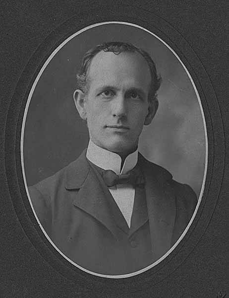
Born and raised in Seattle, Benjamin Donguk Lukoff had his interest in local history kindled at the age of six, when his father bought him settler granddaughter Sophie Frye Bass’s Pig-Tail Days in Old Seattle at the gift shop of the Museum of History and Industry. He studied English, Russian, and linguistics at the University of Washington, and went on to earn his master’s in English linguistics from University College London. His book of rephotography, Seattle Then and Now, was published in 2010. An updated version came out in 2015.
This short street — just over 300 feet long — runs from Airport Way S in the east to Corson Avenue S in the west. It was established in 1903 as Carstens Street, part of Carstens’ Addition to Georgetown, “filed for record at the request of Thomas Carstens on the 4[th] day of June 1903 at 49 Min. past 9 A.M.” This is the first time I’ve seen the actual time of filing on a plat!
Thomas Carstens, born in 1865 in Husum, Germany, near Denmark, came to the Pacific Northwest in 1884, and in 1890 established a butcher shop with his brother, Ernest, which later grew into the Carstens Packing Company.
Clinton A. Snowden, author of History of Washington: The Rise and Progress of an American State, wrote in 1911 of Carstens:
Mr. Carstens, besides being president of the Carstens Packing Company, is president of the Tacoma Wheat Land Company, president of the Pacific Oil Mills, and director of the National Realty Company of Tacoma. He is a member of the Seattle Chamber of Commerce, Seattle Commercial Club, Arctic Club of Seattle, Seattle Manufacturers’ Association, Duwamish River Improvement Club, Tacoma Commercial Club, and Tacoma Chamber of Commerce.
Born and raised in Seattle, Benjamin Donguk Lukoff had his interest in local history kindled at the age of six, when his father bought him settler granddaughter Sophie Frye Bass’s Pig-Tail Days in Old Seattle at the gift shop of the Museum of History and Industry. He studied English, Russian, and linguistics at the University of Washington, and went on to earn his master’s in English linguistics from University College London. His book of rephotography, Seattle Then and Now, was published in 2010. An updated version came out in 2015.
This street, which runs just under 400 feet from Yesler Way and 3rd Avenue S in the northwest to S Washington Street and 4th Avenue S in the southwest, cutting a skewed diagonal through the block, is named for Father Francis X. Prefontaine, Seattle’s first Catholic priest. In 1870, he founded Seattle’s first Catholic church, Our Lady of Good Help, on the block Prefontaine Place cuts through today.
Born and raised in Seattle, Benjamin Donguk Lukoff had his interest in local history kindled at the age of six, when his father bought him settler granddaughter Sophie Frye Bass’s Pig-Tail Days in Old Seattle at the gift shop of the Museum of History and Industry. He studied English, Russian, and linguistics at the University of Washington, and went on to earn his master’s in English linguistics from University College London. His book of rephotography, Seattle Then and Now, was published in 2010. An updated version came out in 2015.
More common in older cities like London (Aldgate, Cheapside, Crosswall, Eastcheap, Houndsditch, Lothbury, Minories, Moorgate, Poultry, Queenhithe, St. Mary Axe, and Walbrook, just to name those that merit a Wikipedia article of their own), single-word street names are a rarity in Seattle. NW Esplanade is one of them. It was platted in 1924 as part of the Golden View Addition, and its extension in 1927 as part of the Loyal Heights Annex.
NW Esplanade runs just over half a mile along the Puget Sound shoreline from Triton Drive NW in the northeast to just shy of the northern boundary of Golden Gardens Park in the southwest. For those who might not know, the word means “a long, open, level area, usually next to a river or large body of water where people may walk.”
Born and raised in Seattle, Benjamin Donguk Lukoff had his interest in local history kindled at the age of six, when his father bought him settler granddaughter Sophie Frye Bass’s Pig-Tail Days in Old Seattle at the gift shop of the Museum of History and Industry. He studied English, Russian, and linguistics at the University of Washington, and went on to earn his master’s in English linguistics from University College London. His book of rephotography, Seattle Then and Now, was published in 2010. An updated version came out in 2015.
Thomas Prosch, who named Conkling Place W after his mother, didn’t neglect to name something after himself. Prosch Avenue W runs about ¼ mile from W Barrett Street in the north to 13th Avenue W in the south. It appears as Prosch Place in Prosch’s Queen Anne Addition to the City of Seattle in 1909. Six years later, Prosch was killed in a car crash that also took the lives of his wife, Virginia; painter Harriet Foster Beecher; and Margaret Lenora Denny, namesake of Lenora Street.
Thomas Wickham Prosch, 1890
Portion of Prosch’s Queen Anne Addition to the City of Seattle, 1909
Born and raised in Seattle, Benjamin Donguk Lukoff had his interest in local history kindled at the age of six, when his father bought him settler granddaughter Sophie Frye Bass’s Pig-Tail Days in Old Seattle at the gift shop of the Museum of History and Industry. He studied English, Russian, and linguistics at the University of Washington, and went on to earn his master’s in English linguistics from University College London. His book of rephotography, Seattle Then and Now, was published in 2010. An updated version came out in 2015.
This street runs just over a thousand feet from 10th Avenue W and W Bertona Street in the northwest to 8th Avenue W and W Dravus Street in the southeast. It was named after Susan Conkling Prosch, mother of Thomas Prosch, who filed Prosch’s Queen Anne Addition to the City of Seattle in 1909. (Prosch was a noted local journalist and historian, who didn’t neglect to name Prosch Avenue W after himself.)
Susan Conkling Prosch, 1897
Conkling Place was one of the streets retained when George E. Morford and Gertrude Keen Morford filed their plat of Queen Anne Park in 1926. The Queen Anne Historical Society has an extensive article on the latter subdivision, which was among those in Seattle with all-too-common racial restrictive covenants, in this case excluding Blacks and Asians.
Portion of Prosch’s Queen Anne Addition to the City of Seattle, 1909.
Born and raised in Seattle, Benjamin Donguk Lukoff had his interest in local history kindled at the age of six, when his father bought him settler granddaughter Sophie Frye Bass’s Pig-Tail Days in Old Seattle at the gift shop of the Museum of History and Industry. He studied English, Russian, and linguistics at the University of Washington, and went on to earn his master’s in English linguistics from University College London. His book of rephotography, Seattle Then and Now, was published in 2010. An updated version came out in 2015.
This street runs nearly four miles from Chelan Avenue SW, SW Spokane Street, and W Marginal Way SW in the north to 16th Avenue SW and SW Roxbury Street in the south — all the way from the Duwamish Waterway to the southern city limits. It was given its current name in 1940 — before then, it had carried the names of Youngstown Place, 21st Avenue SW, 22nd Avenue SW, McKinnon Place SW, 23rd Avenue SW, and 24th Avenue SW. As The Seattle Times explained on May 14, 1940, “Delridge” came from “the dells and ridges through which the thoroughfare runs,” and had been “suggested by West Seattle community organizations.”
Born and raised in Seattle, Benjamin Donguk Lukoff had his interest in local history kindled at the age of six, when his father bought him settler granddaughter Sophie Frye Bass’s Pig-Tail Days in Old Seattle at the gift shop of the Museum of History and Industry. He studied English, Russian, and linguistics at the University of Washington, and went on to earn his master’s in English linguistics from University College London. His book of rephotography, Seattle Then and Now, was published in 2010. An updated version came out in 2015.
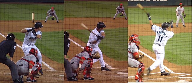
This street runs ¼ mile from 1st Avenue S in the west to 4th Avenue S in the east. West of 1st, it’s S Atlantic Street — its original name — and east of 4th, it’s the beginning of Interstate 90. It is part of State Route 519, a short highway that connects I-90 to Washington State Ferries’ Colman Dock.
Edgar Martínez was a member of the Seattle Mariners baseball team from 1987 to 2004. This stretch of S Atlantic Street was renamed in his honor the year he retired.
Now — why is it Edgar Martinez Drive S instead of S Edgar Martinez Drive, since east–west streets in Seattle have their directional designators at the beginning? I asked Paul Jackson this in 2005. Jackson, who was then the Seattle Department of Transportation’s manager of traffic, signs, and markings, responded:
I appreciate your desire to see our City’s sign system remain consistent.… But ultimately, there is nothing requiring such a naming convention in the Seattle Municipal Code.… In this case, those proposing the street name change wanted to see Edgar Martínez’s name out front. Because this is only a three-block stretch of street (from 1st Avenue S to 4th Avenue S), and does not have any addresses along it, the decision was made to veer slightly from the typical naming convention. The term “drive” was agreed upon to evoke Mr. Martínez’s batting skills at the plate.
Born and raised in Seattle, Benjamin Donguk Lukoff had his interest in local history kindled at the age of six, when his father bought him settler granddaughter Sophie Frye Bass’s Pig-Tail Days in Old Seattle at the gift shop of the Museum of History and Industry. He studied English, Russian, and linguistics at the University of Washington, and went on to earn his master’s in English linguistics from University College London. His book of rephotography, Seattle Then and Now, was published in 2010. An updated version came out in 2015.
Born and raised in Seattle, Benjamin Donguk Lukoff had his interest in local history kindled at the age of six, when his father bought him settler granddaughter Sophie Frye Bass’s Pig-Tail Days in Old Seattle at the gift shop of the Museum of History and Industry. He studied English, Russian, and linguistics at the University of Washington, and went on to earn his master’s in English linguistics from University College London. His book of rephotography, Seattle Then and Now, was published in 2010. An updated version came out in 2015.
This street, which runs just over 400 feet from 36th Avenue W in the west to 34th Avenue W in the east, was established in 1905 as part of the Lawton Park Addition to Seattle. It was named after Evan Sidebottom McCord, a Seattle lawyer, and his wife, Elizabeth Chenault Bennett McCord, who were among the nine owners of property encompassed by the plat.
Born and raised in Seattle, Benjamin Donguk Lukoff had his interest in local history kindled at the age of six, when his father bought him settler granddaughter Sophie Frye Bass’s Pig-Tail Days in Old Seattle at the gift shop of the Museum of History and Industry. He studied English, Russian, and linguistics at the University of Washington, and went on to earn his master’s in English linguistics from University College London. His book of rephotography, Seattle Then and Now, was published in 2010. An updated version came out in 2015.
I am certainly not the first person to have been interested in, or to blog about, the origins of Seattle street names. One of the historians whose work I’ve been inspired by is Valarie Bunn, who writes Wedgwood in Seattle History (though she does not restrict herself to Wedgwood).
In “The Fischer Farm in Meadowbrook,” from 2013, she writes about August and Wilhelmine Fischer, who came to Seattle from Saxony, Germany, in 1888, and lived here until they died in 1940 and 1941, respectively. In 1922, they established what is now Fischer Place NE as Fischer Street in the plat of Fischer’s Highway Garden Tracts. (“Highway” because of Victory Way [now Lake City Way NE, part of State Route 522] and Pacific Highway [now Ravenna Avenue NE]. The latter lost its Pacific Highway designation to the former that same year, and the designation shifted farther west to what is now Aurora Avenue N a number of years later.) I highly recommend this article and her entire blog.
Born and raised in Seattle, Benjamin Donguk Lukoff had his interest in local history kindled at the age of six, when his father bought him settler granddaughter Sophie Frye Bass’s Pig-Tail Days in Old Seattle at the gift shop of the Museum of History and Industry. He studied English, Russian, and linguistics at the University of Washington, and went on to earn his master’s in English linguistics from University College London. His book of rephotography, Seattle Then and Now, was published in 2010. An updated version came out in 2015.
This street, which runs about 850 feet from NE 63rd Street and 17th Avenue NE in the northwest to 20th Avenue NE in the southeast, was established in 1906 as part of the University Scenic Addition to the City of Seattle, platted by “Naomi A. Young and S.E. Young, her husband.”
Born and raised in Seattle, Benjamin Donguk Lukoff had his interest in local history kindled at the age of six, when his father bought him settler granddaughter Sophie Frye Bass’s Pig-Tail Days in Old Seattle at the gift shop of the Museum of History and Industry. He studied English, Russian, and linguistics at the University of Washington, and went on to earn his master’s in English linguistics from University College London. His book of rephotography, Seattle Then and Now, was published in 2010. An updated version came out in 2015.
Fairview Avenue is one of a handful in the city that changes directional designations twice along a continuous stretch. The street begins in the south at Virginia Street as Fairview Avenue, but becomes Fairview Avenue N a block and a half to the north as it crosses Denny Way, and a mile north and east of that becomes Fairview Avenue E at E Galer Street and Eastlake Avenue E. It continues to E Roanoke Street, two miles from its origin, where it is interrupted by the Mallard Cove houseboat community. Picking up a block to the north, it then runs half a mile from E Hamlin Street to Fuhrman Avenue E and Eastlake Avenue E, just south of the University Bridge.
The Fairview Homestead Association, according to Paul Dorpat, was intended to “help working families stop paying rents and start investing in their own homes. Innovative installment payments made the lots affordable and many of the homes were built by those who lived in them.”
I assume Fairview took its name from the view of Lake Union and what is now Wallingford that is still barely visible today from what is now the Cascade neighborhood.
1931 view looking north toward Lake Union along Fairview Avenue N, Courtesy of the Seattle Municipal Archives, Identifier 5265
Born and raised in Seattle, Benjamin Donguk Lukoff had his interest in local history kindled at the age of six, when his father bought him settler granddaughter Sophie Frye Bass’s Pig-Tail Days in Old Seattle at the gift shop of the Museum of History and Industry. He studied English, Russian, and linguistics at the University of Washington, and went on to earn his master’s in English linguistics from University College London. His book of rephotography, Seattle Then and Now, was published in 2010. An updated version came out in 2015.
This street runs just shy of 2,000 feet from NE Pacific Street in the west, just east of the University Bridge, to NE Columbia Road in the east, on the University of Washington South Campus.
Originally Lake Avenue in the 1890 Brooklyn Addition to Seattle, as it ran along the north shore of Lake Union, it became Northlake Avenue at some point between then and 1901, based on my search of Seattle Times, Seattle Star, and Seattle Post-Intelligencer archives. It starts being referred to as Northlake Way in 1935, though it seems this wasn’t formalized until 1956.
Portion of Map of Brooklyn Addition to Seattle, 1890, showing Lake Avenue (now NE Boat Street) and Railroad Avenue (now NE Pacific Street)
In 1960, Jerry Bryant of Bryant’s Marina proposed that all of Northlake Way — beginning far to the west, at the Fremont Bridge — receive the new name of Boat Street, but the 1962 ordinance establishing Boat Street only changes the name of the few blocks between the University Bridge and the UW campus. The Seattle P-I reports on December 22, 1960, that the Street Naming Committee of the Board of Public works rejected the proposal “because the present name is more descriptive,” but Bryant went ahead and filed his proposal with the City Council anyway in 1961.
According to The Seattle Times on May 24, 1962, the Board of Public Works once again asked the City Council to reject the proposal, which was “backed by more than 50 marine firms or individuals… [and] the University Commercial Club,” but on June 20, the Times reported that the City Council Streets and Sewers Committee approved the change. This met with much opposition. On July 2, the Times published a letter from Vince Lieb, 668 NE Northlake Way, that read, in part, that “numerous business firms… are more than a little chagrined at the City Council’s recent move… to please a minority of merchants who hawk their wares along the way,” and wondered if this might set a precedent:
We can think of such dandies as “Chop Suey Street,” “Gas and Oil Street,” “Beer Street,” and “Fish Street.” How about “Sand and Gravel Street” for a paved thoroughfare?
That same day, according to the P-I, the City Council postponed the implementation of the name change, sending it back to committee, and on July 10, according to the Times, the committee said it would give proponents and opponents two weeks to gather signatures, as the original petition had somehow been lost. Finally, on the 24th, they came up with a compromise: The name would be changed between the University Bridge and 15th Avenue NE only. This is where Bryant’s Marina was located, as well as the Jensen Motor Boat Company, which lasted until 2019 and was the last shipyard left on NE Boat Street.
From The Seattle Times, July 25, 1962
Today, Fritz Hedges Waterway Park — built on the former site of the marina — occupies most of the Boat Street waterfront.
Born and raised in Seattle, Benjamin Donguk Lukoff had his interest in local history kindled at the age of six, when his father bought him settler granddaughter Sophie Frye Bass’s Pig-Tail Days in Old Seattle at the gift shop of the Museum of History and Industry. He studied English, Russian, and linguistics at the University of Washington, and went on to earn his master’s in English linguistics from University College London. His book of rephotography, Seattle Then and Now, was published in 2010. An updated version came out in 2015.
This Olmsted boulevard was designed in 1910 as Jefferson Boulevard, the entrance to Jefferson Park. It runs about 1⅕ miles from Beacon Avenue S and S Alaska Street in the southwest to S Winthrop Street in the northeast, which also forms part of the park boulevard. After crossing Martin Luther King Jr. Way S and Rainier Avenue S, it continues on as S Mount Baker Boulevard, ending at Mount Baker Park.
In 1914, it was renamed Cheasty Boulevard after E.C. (Edward) Cheasty (born 1864), who died that year. He had been police commissioner, commissioner of the Alaska–Yukon–Pacific Exposition, and a member of the park board from 1907 to 1910 and 1912 to his death, according to the Don Sherwood Park History Files. He also ran Cheasty’s Store, a downtown haberdashery, from 1888 until his death.
Speaking of his death, it sadly appears that it was due to suicide. He fell from the 10th floor of the Washington Hotel — the same hotel in which fellow businessman Frank B. Hubbell killed himself in 1905.
Front-page article on Cheasty’s death, The Seattle Star, June 13, 1914
Born and raised in Seattle, Benjamin Donguk Lukoff had his interest in local history kindled at the age of six, when his father bought him settler granddaughter Sophie Frye Bass’s Pig-Tail Days in Old Seattle at the gift shop of the Museum of History and Industry. He studied English, Russian, and linguistics at the University of Washington, and went on to earn his master’s in English linguistics from University College London. His book of rephotography, Seattle Then and Now, was published in 2010. An updated version came out in 2015.
This street runs just about 1,000 feet from 31st Avenue S in the west to Colman Park in the east. West of 31st Avenue, it’s S Walker Street, and the right-of-way extends through the park to Lake Washington Boulevard S as the Dose Terrace steps.
Born and raised in Seattle, Benjamin Donguk Lukoff had his interest in local history kindled at the age of six, when his father bought him settler granddaughter Sophie Frye Bass’s Pig-Tail Days in Old Seattle at the gift shop of the Museum of History and Industry. He studied English, Russian, and linguistics at the University of Washington, and went on to earn his master’s in English linguistics from University College London. His book of rephotography, Seattle Then and Now, was published in 2010. An updated version came out in 2015.
This street runs a tenth of a mile along the Bitter Lake waterfront from N 134th Street to the grounds of Broadview-Thomson K-8 School and Bitter Lake Playground. It was established in 1923 as part of Bitter Lake Villa Tracts.
Bitter Lake itself was so named because, as HistoryLink puts it, “A small, lake-bound sawmill operation at the southwest corner of Bitter Lake contracted with the Puget Mill and Brown Bay Logging Company to process their lumber cut from nearby forests. The tannic acid from logs dumped into the lake was so bitter that horses refused to drink from it, thus giving the 20-acre pond its name.” Its native name is čʼalqʼʷadiʔ, meaning ‘blackcaps on the sides’.
Born and raised in Seattle, Benjamin Donguk Lukoff had his interest in local history kindled at the age of six, when his father bought him settler granddaughter Sophie Frye Bass’s Pig-Tail Days in Old Seattle at the gift shop of the Museum of History and Industry. He studied English, Russian, and linguistics at the University of Washington, and went on to earn his master’s in English linguistics from University College London. His book of rephotography, Seattle Then and Now, was published in 2010. An updated version came out in 2015.
This short street in the Washington Park neighborhood runs just over a tenth of a mile from Lake Washington Boulevard E in the west to 36th Avenue E in the east, a block south of E Mercer Street.
The Pacific Coast Company rail, shipping and coal operations served the West Coast from the mid-19th century until its last railways were abandoned or sold in the mid-20th century. Though the company was organized under the Pacific Coast Company name in late 1897, it comprised several existing organizations, most notably the Pacific Coast Steamship Co., Pacific Coast Coal Co., and the Pacific Coast Railway. In Seattle, the Columbia & Puget Sound Railroad, originally the Seattle & Walla Walla, became part of the Pacific Coast Railway in 1916. The several operations of Pacific Coast Co., which also included a cement company and engineering company, played an important role in the development of King County resources and the development of Seattle and outlying communities.
Born and raised in Seattle, Benjamin Donguk Lukoff had his interest in local history kindled at the age of six, when his father bought him settler granddaughter Sophie Frye Bass’s Pig-Tail Days in Old Seattle at the gift shop of the Museum of History and Industry. He studied English, Russian, and linguistics at the University of Washington, and went on to earn his master’s in English linguistics from University College London. His book of rephotography, Seattle Then and Now, was published in 2010. An updated version came out in 2015.
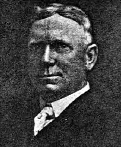
Continuing the story we began in Hubbell Place, we take up W McLaren Street in Magnolia, which runs about 950 feet from Perkins Lane W in the west to 43rd Avenue W and W Ruffner Street in the east.
As was previously mentioned, the ordinance establishing Hubbell Place “accept[s] a deed of conveyance from George S. McLaren, et ux, and Helen Moore Hubbell” for the land. Who was this McLaren, and was he the namesake of W McLaren Street?
Photo of George S. McLaren that ran in the August 4, 1911, issue of The Seattle Times
George S. McLaren appears to have been on the finance committee of the 1909 Alaska–Yukon–Pacific Exposition, and Clarence Bagley’s History of Seattle from the Earliest Settlement to the Present Time notes that he was among the founders of Seattle’s Nile Shrine Temple in 1908. He is mentioned in the press as being an investment manager for the Northwestern Mutual Life Insurance Company, a founder of the Lake Chelan Land Company, and a representative of the Milwaukee Road in purchasing tideland real estate. And in February 1906, he was apparently one of the local businessmen who proclaimed, in the words of The Seattle Star, that “Something Will Be Done to Lift From the Shoulders of This City the Burden Placed There by the Sunset Telephone Co.,” and managed to get 2,000 similarly minded “long-suffering contributors to the yawning coffers of the Sunset concern” to assemble at the Grand Opera House to determine how best to “[remedy] the existing evil.”
In short, he does appear to have been, as The Hood River Glacier described him on August 10, 1911, “one of the leading business men of Seattle,” whose death “of ptomaine poisoning caused by eating canned mushrooms at a dinner at Tacoma” must have come as a great shock to the community.
As for W McLaren Street? It’s part of the Magnolia Heights subdivision, which was platted in 1907.
Advertisement for the Magnolia Heights subdivision in The Seattle Star, May 4, 1907
I thought it possible that George S. McLaren and W McLaren Street were related, but couldn’t be certain — nothing appeared in historical newspapers to definitively link the two. Then I looked him up in AncestryLibrary.com, which Seattle Public Library cardholders can access for free. And there it was! His probate records from 1911 contained an inventory of his assets, and among them were a “note of Magnolia Heights Co. for $333.33, dated September 5, 1907” and a “note of Parry Investment Co., for $155.64, dated July 17, 1907.” (Incidentally, both were valued at nil, though his total assets amounted to $367,228.76, or about $9.5 million in today’s money.)
Portion of inventory of the assets at death of George S. McLaren, from King County probate records via AncestryLibrary.com
As you can see in the newspaper advertisement above, the Parry Investment Company marketed lots in Magnolia Heights, which was platted by the Magnolia Heights Company. I’m willing on that basis to say that George McLaren’s name lives on in W McLaren Street.
Born and raised in Seattle, Benjamin Donguk Lukoff had his interest in local history kindled at the age of six, when his father bought him settler granddaughter Sophie Frye Bass’s Pig-Tail Days in Old Seattle at the gift shop of the Museum of History and Industry. He studied English, Russian, and linguistics at the University of Washington, and went on to earn his master’s in English linguistics from University College London. His book of rephotography, Seattle Then and Now, was published in 2010. An updated version came out in 2015.
Hubbell Place does not appear in the original plat of the area, A.A. Denny’s Broadway Addition to the City of Seattle (1890). When it was established in 1906, it ran only one block, diagonally from 9th Avenue and Union Street to Terry Avenue and Pike Street. Today, however, it begins farther southwest, at 7th Avenue and Spring Street, making its full length just about ⅓ of a mile. (The extension came about because of the construction of Interstate 5 through Downtown — the frontage road on the east side of I-5 connected to the existing Hubbell Place and took its name in 1966.)
The ordinance establishing Hubbell Place “accept[s] a deed of conveyance from George S. McLaren, et ux, and Helen Moore Hubbell” for the land. Et ux is simply Latin for “and wife.” But who was this Helen Hubbell — and, for that matter, who was this George McLaren? Could he be connected with W McLaren Street in Magnolia? (We’ll take that up in a subsequent post.)
Searching for any city ordinance mentioning Hubbell, we come across one “granting permission to Frank B. Hubbell, his heirs and assigns, to lay down, maintain and operate steam and water pipes in and across certain streets and alleys in the City of Seattle for the purpose of conducting steam and water,” passed in 1905. Yet in 1907 it was repealed, and in 1909 a similar ordinance was passed “granting permission to Helen Moore Hubble [italics mine]” to do the same thing. (This franchise expired a number of decades later.) Why might this have happened?
Apparently, Frank B. Hubbell died in 1905, only a few months after he married Helen. As the (Walla Walla) Evening Statesman reported on October 28 of that year, under the headline ‘Seattle capitalist commits suicide’,
Mystery surrounds the suicide by gas last night of Frank B. Hubbell, one of the most prominent real estate men and capitalists in the city. His bride of three months, who occupied separate apartments in a fashionable hotel, discovered him unconscious on the floor of his room this morning. Hubbell was worth half a million dollars and his financial standing was gilt edge. He came from New York a few years ago. Three physicians failed to save his life and he died at 10 this morning. No cause is known for his suiciding. Hubbel [sic] when found had the gas tube in his mouth. Domestic and not financial troubles, are believed to have been the cause. Hubbell had under way some of the greatest public improvements in the history of the city. He has constantly been drawing on eastern capital to accomplish his plans.
Though the Evening Statesman did not believe financial troubles to be the cause of his suicide, The Yakima Heraldreported in 1910, under the headline ‘Closing of Hubbell estate solves suicide mystery’, that he owed $135,000 to Seattle banks, could not pay without putting his fortune at risk, and so decided to kill himself to keep his creditors at bay and preserve his estate for his wife. (That figure corresponds to $3.5 million in today’s money. The Herald went on to say that his total estate amounted to $650,000, or about $16.8 million.)
Frank and Helen Moore Hubbell had one daughter, Helen Frances Hubbell, who apparently died a few months after her 17th birthday in a car accident. She was born in May 1906, 6½ months after the death of her father. The elder Helen died in 1948 at the age of 70.
Born and raised in Seattle, Benjamin Donguk Lukoff had his interest in local history kindled at the age of six, when his father bought him settler granddaughter Sophie Frye Bass’s Pig-Tail Days in Old Seattle at the gift shop of the Museum of History and Industry. He studied English, Russian, and linguistics at the University of Washington, and went on to earn his master’s in English linguistics from University College London. His book of rephotography, Seattle Then and Now, was published in 2010. An updated version came out in 2015.


