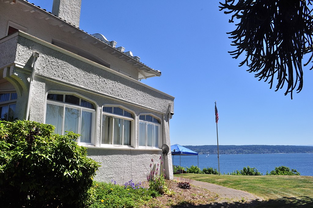
This street, created in 1906 as part of the Lake Shore View Addition to Seattle, begins in the north at NE 105th Street and Exeter Avenue NE, and curves south for a mile along the Burke-Gilman Trail, which parallels the Lake Washington shoreline, to a dead end at the north boundary of Matthews Beach Park. Unlike most, though not all, boulevards in Seattle, this one is not one of the Olmsted boulevards designed by John Charles Olmsted in 1903.
Born and raised in Seattle, Benjamin Donguk Lukoff had his interest in local history kindled at the age of six, when his father bought him settler granddaughter Sophie Frye Bass’s Pig-Tail Days in Old Seattle at the gift shop of the Museum of History and Industry. He studied English, Russian, and linguistics at the University of Washington, and went on to earn his master’s in English linguistics from University College London. His book of rephotography, Seattle Then and Now, was published in 2010. An updated version came out in 2015.
This narrow street, created in 1926 as part of Riviera Beach, an Addition to King County, Washington, Divisions № 1, 2, 3, and 4, and situated between the shoreline of Lake Washington and the right-of-way of the Northern Pacific Railway, appears on the plats simply as “Road” — it first appears in The Seattle Times on July 20, 1930, as “Riviera Beach Road,” and then on July 2, 1932, with its current name. The name simply means ‘coastline’ in Italian.
Today, Riviera Place NE begins at the north city limits, where Seattle meets Lake Forest Park at the NE 145th Street right-of-way, and goes nearly a mile south along the Lake Washington shoreline to a spot a few houses north of NE 125th Street, where it ends at one house and picks up again on the other side of its neighbor. From there, it runs 1¼ miles south to its end at Lake Shore Boulevard NE between NE 100th Street and NE 103rd Street. The portions between the NE 135th Street right-of-way and NE 125th Street are private.
Riviera Place NE is probably most notable to the city at large for being the location of the NE 130th Street End beach (renamed Lake City Beach Park in 2025), which became an official park in 2019 after years of controversy. It’s not, strictly speaking, a shoreline street end, because it’s owned by Seattle Parks and Recreation, rather than being a right-of-way under the jurisdiction of the Seattle Department of Transportation. This is because it was never properly dedicated to the public in 1932 (see background and court filings). For years, it had been treated as just another shoreline street end, but in 2012, when the city announced its intention to make improvements to the beach to improve public access, the neighbors on either side filed suit, and ended up having their ownership of the lot confirmed. The city ended up having to exercise its right of eminent domain, condemned the property, and paid the neighbors $400,000 each. (As unfortunate as it was to have to pay $800,000 for the street end, I’d say it was worth it, as NE 130th is the only accessible shoreline street end north of NE 43rd Street, and the only public lake access, period, north of Matthews Beach [around where NE 95th Street would be if it had been platted into the water].)
Born and raised in Seattle, Benjamin Donguk Lukoff had his interest in local history kindled at the age of six, when his father bought him settler granddaughter Sophie Frye Bass’s Pig-Tail Days in Old Seattle at the gift shop of the Museum of History and Industry. He studied English, Russian, and linguistics at the University of Washington, and went on to earn his master’s in English linguistics from University College London. His book of rephotography, Seattle Then and Now, was published in 2010. An updated version came out in 2015.
This short street in Seattle’s Windermere neighborhood runs from 60th Avenue NE and NE 55th Street in the southwest to 63rd Avenue NE and NE 57th Street in the northeast. It was likely named after Lochkelden, the mansion built in 1907 for Rolland Herschel Denny (1851–1939) and his wife, Alice Martha Kellogg Denny (1857–1940). Rolland was just six weeks old when the Denny Party landed at Alki Point in November 1851. Lochkelden — owned since 1974 by Sun Myung Moon’s Unification Church — was itself named for Lake Washington, of which it has a commanding view (loch being Scottish for ‘lake’) and its owners: Kellogg and Denny.
Note added March 14, 2024: It appears, per Clay Eals at PaulDorpat.com, that the church put Lockhelden on the market in 2022 and it just sold for $6 million. The purchasers are developers, and property owned by religious organizations cannot get landmark protection against the owner’s will, so the mansion’s days are almost certainly numbered.
Born and raised in Seattle, Benjamin Donguk Lukoff had his interest in local history kindled at the age of six, when his father bought him settler granddaughter Sophie Frye Bass’s Pig-Tail Days in Old Seattle at the gift shop of the Museum of History and Industry. He studied English, Russian, and linguistics at the University of Washington, and went on to earn his master’s in English linguistics from University College London. His book of rephotography, Seattle Then and Now, was published in 2010. An updated version came out in 2015.
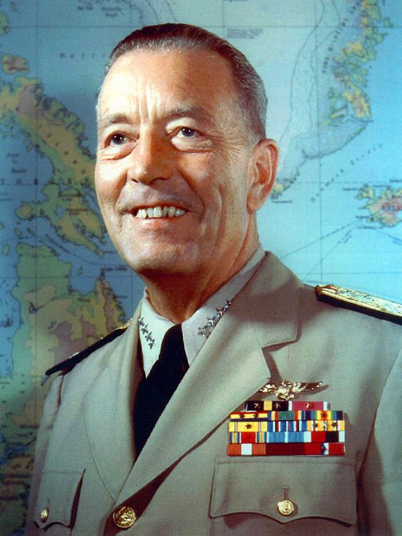
It isn’t often that a vintage newspaper article explicitly states the reason behind a new street’s naming, but when it comes to Radford Drive, we’re in luck. On November 30, 1940, the Seattle Post-Intelligencer reported, under the headline ‘Work started at Sand Point Homes project’, that ground had been broken the day before on a project to house 150 enlisted men, plus their families, from the adjacent Sand Point Naval Air Station. (The project was said to cost $620,000, which is ¾ of the average price of a single home in Seattle today!) Rather amusingly, the air station’s commandant, Captain Ralph Wood, is quoted as saying “the days when the sailor was a bachelor and a derelict have long since passed” as justification for the need for military family housing. The article goes on to say that:
Street entrance to the area will be named Radford Drive in honor of Commander Arthur W. Radford, former commandant of the Sand Point base, who launched the expansion program which has resulted in its present growth.
Arthur W. Radford (1896–1973), who had been appointed commandant in 1939, was promoted to captain in 1942 and to rear admiral in 1943. He became vice admiral in 1945, and was appointed by President Harry S. Truman as vice chief of naval operations in 1948. In 1949, he was made high commissioner of the Trust Territory of the Pacific Islands as well as commander-in-chief of the U.S. Pacific Fleet, and in 1953 he became President Dwight D. Eisenhower’s selection as chairman of the Joint Chiefs of Staff. He retired from the Navy in 1957.
Admiral Arthur W. Radford
Today, the housing complex, redeveloped in 2001, is known as Radford Court, and is owned by the University of Washington, though some units are available to the public. Interestingly, the entrance to the neighborhood from NE 65th Street is signed Radford Drive NE and is on University-owned land, while the publicly owned street is legally NE Radford Drive, but not signed at all — and the addresses for the complex are on 65th Avenue NE (one of the city streets, the other being NE 64th Street, that connects directly to the property).*
* Yes, NE 65th Street and 65th Avenue NE intersect here. Because of how Seattle’s street naming system works, Windermere and Laurelhurst are the site of a number of similar intersections, including those for 60th, 59th, 57th, 55th, 54th, 50th, 47th, 45th, 43rd, 41st, and 40th.
Born and raised in Seattle, Benjamin Donguk Lukoff had his interest in local history kindled at the age of six, when his father bought him settler granddaughter Sophie Frye Bass’s Pig-Tail Days in Old Seattle at the gift shop of the Museum of History and Industry. He studied English, Russian, and linguistics at the University of Washington, and went on to earn his master’s in English linguistics from University College London. His book of rephotography, Seattle Then and Now, was published in 2010. An updated version came out in 2015.
This street, which originates along with the rest of the heart of Ballard in the 1889 plat of Gilman Park, was named for šilšul, a village of the shill-shohl-AHBSHpeople along what is today known as Salmon Bay. Meaning ‘tucked away inside’ in the Lushootseed language, it is one of two remaining Native place names in Seattle, the other being Licton Springs (liq’təd). (Note added May 20, 2023: I should have written that it is one of two Native place names in Seattle that remain in common use. The Duwamish are still here, and so are their names.)
Why, then, is the Shilshole Bay name applied to the body of water west of the Ballard Locks? Shouldn’t Shilshole Avenue, Shilshole Bay, and šilšul all be in the same location? According to Edmond Stephen Meany’s 1923 Origin of Washington Geographic Names, citing early settler Arthur A. Denny’s 1888 Pioneer Days on Puget Sound,
In December, 1852, Arthur A. Denny, knew the bay as “Shilshole.” It was later changed to Salmon Bay because it was thought to be frequented by Salmon.
Today, Shilshole Avenue NW begins at 14th Avenue NW in the east and goes ⅘ of a mile northwest to 24th Avenue NW, just short of NW Market Street.
Born and raised in Seattle, Benjamin Donguk Lukoff had his interest in local history kindled at the age of six, when his father bought him settler granddaughter Sophie Frye Bass’s Pig-Tail Days in Old Seattle at the gift shop of the Museum of History and Industry. He studied English, Russian, and linguistics at the University of Washington, and went on to earn his master’s in English linguistics from University College London. His book of rephotography, Seattle Then and Now, was published in 2010. An updated version came out in 2015.
In the early 1870s, the Denny and Mercer families gradually began to systematically subdivide their large land holdings on the south and east slopes of Queen Anne Hill. When a severe windstorm blew down thousands of trees in the north district in 1875, views opened up and land seekers turned their attentions beyond Belltown. Real estate speculators new to the territory arrived and began to buy up property on the crest of Queen Anne Hill. Some of these speculators also became developers, such as George Kinnear, or builder-developers, such as Isaac Bigelow.
Though its proximity to Boston and Lynn Streets suggest a tribute to Newton, Massachusetts, neither the Georges nor the Bigelows appear to have a connection to the state, so it seems this one should be chalked up to Isaac Bigelow’s middle name.
Today, Newton Street begins in Magnolia as W Newton Street at 30th Avenue W, and goes nearly half a mile east to 23rd Avenue W. There is then a two-block stretch from 15th Avenue W to 13th Avenue W in Interbay, and then the “original” Newton Street, which stretches almost a half mile from 1st Avenue N to Taylor Avenue N, followed by another two-block stretch from Dexter Avenue N to just past 8th Avenue N. On the east side of Lake Union, E Newton Street picks up again at Terry Pettus Park, just west of Fairview Avenue E, and goes ¼ mile to Boylston Avenue E and Lakeview Boulevard E. There follows another ¼-mile stretch from Broadway E to Everett Avenue E. East of there, Newton exists in a number of short segments through Montlake, and then enjoys a run of ⅓ of a mile from 37th Place E to 43rd Avenue E in Madison Park.
Born and raised in Seattle, Benjamin Donguk Lukoff had his interest in local history kindled at the age of six, when his father bought him settler granddaughter Sophie Frye Bass’s Pig-Tail Days in Old Seattle at the gift shop of the Museum of History and Industry. He studied English, Russian, and linguistics at the University of Washington, and went on to earn his master’s in English linguistics from University College London. His book of rephotography, Seattle Then and Now, was published in 2010. An updated version came out in 2015.
The sleek Latona was originally built as a pleasure craft for businessman James Colman to use on the Sound. Dr. E.C. Kilbourne, a dentist with extensive real estate holdings north of Lake Union, purchased the Latona and took her to Lake Washington by way of the Duwamish River and Black River, the lake’s outlet. After a few years of serving farms, mining camps, and logging operations around Lake Washington, the Latona came through the narrow channel dug in 1886 to Portage Bay and thereafter served Lake Union.
Today, Latona Avenue NE begins as a shoreline street end just south of NE Northlake Way and goes nearly 1¾ miles north to 2nd Avenue NE and Woodlawn Avenue NE near the eastern end of Green Lake. It reappears on the other side of the Green Lake Park playground and community center at E Green Lake Drive N, and goes a further ⅓ of a mile to just past NE 77th Street, where it is stopped by Interstate 5. Finally, on the north side of I-5, it goes nearly ½ a mile from NE 81st Street to NE 91st Street, interrupted by a half-block segment just north of NE 88th Street where it takes the form of a footpath, and a half-block segment just north of NE 90th Street where it appears to have been incorporated into neighbors’ yards and driveways.
Latona Avenue NE right-of-way between NE 90th Street and NE 91st Street in Maple Leaf. The northern half is paved, but ends at an unpaved alley; the southern half appears to be serving as neighbors’ driveways at either end, the remainder being treated as part of their yards.
Born and raised in Seattle, Benjamin Donguk Lukoff had his interest in local history kindled at the age of six, when his father bought him settler granddaughter Sophie Frye Bass’s Pig-Tail Days in Old Seattle at the gift shop of the Museum of History and Industry. He studied English, Russian, and linguistics at the University of Washington, and went on to earn his master’s in English linguistics from University College London. His book of rephotography, Seattle Then and Now, was published in 2010. An updated version came out in 2015.
This winding, semicircular street runs almost ⁹⁄₁₀ of a mile from 15th Avenue NW and NW 100th Street in the east to Triton Drive NW, NW Neptune Place, and NW 100th Street in the west, descending 300 feet to Puget Sound along the way. Named after the Blue Ridge community, it was established in 1930 as part of the plat of Blue Ridge, an Addition to King County, Washington (rather than to Seattle, as the far northwestern section of the city wouldn’t be annexed until 1953).
No property in said Addition shall at any time be sold, conveyed, rented, or leased in whole or in part to any person or persons not of the White or Caucasian race. No person other than one of the White or Caucasian race shall be permitted to occupy any property in said addition or portion thereof or building thereon except a domestic servant actually employed by a person of the White or Caucasian race where the latter is an occupant of such property.
Uniquely, as they note, the restrictions on membership in the Blue Ridge Club, established in 1941 and forerunner of today’s homeowner association, were slightly different:
No Asiatic, Negro or any person born in the Turkish Empire, nor lineal descendant of such person shall be eligible for membership in the Club.
They speculate this restriction on Ottoman citizens and descendants thereof was aimed at Sephardic Jews (Seattle is said to have the third largest population in the country), although if that is the case, I wonder why the restriction wasn’t against all Jews, as was done in Broadmoor and the Sand Point Country Club. At any rate, it would seem to have affected not only Sephardim but Arabs, Levantines, and North Africans in general. These restrictions were finally lifted in 1989, decades after they became unenforceable.
Blue Ridge says that “The development of the Blue Ridge community and the government-engineered policies of segregation brings some controversy to the early days of the neighborhood. However, today Blue Ridge is diverse and welcoming to anyone wanting to share in all that it has to offer.” As the interactive map on the Seattle Civil Rights & Labor History Project page on Blue Ridge shows, though, the covenants had the desired effect — the neighborhood is still around 81% white, 12% Asian… and just 0.5% Black.
As far as being an “exclusive” neighborhood goes, Blue Ridge is more like Windermere than the above-mentioned Broadmoor and Sand Point Country Club; it features a private waterfront park, but all the streets are public, and there are even two very small public parks (Blue Ridge Circle and Blue Ridge Places) plus the wooded Mary Avenue Trail to the southern boundary of Carkeek Park.
Ten or so years ago I saw a Private Property sign at the trailhead, put up by the Blue Ridge Club, but it was gone the next time I visited — I can’t remember if I complained or someone else did. (The woods are private, but the trail is Mary Avenue NW right-of-way.) This wasn’t in the original plat, but according to an old Flickr chat I had with Andreas “Severinus” Breuer, “there was apparently a WPA project approved to install a 30′-wide gravel road between 100th and 110th (apparently now NW Carkeek Park Road).… I imagine the ravine would look quite different if a 30′ gravel road had been put in, so presumably this plan wasn’t carried out. But a 1940 engineering map shows a surveyed ROW from 105th to the Carkeek border, and in Carkeek there seems to be a route that follows the WPA route (Clay Pit Trail > Hillside Trail > Brick Road Trail > Road). Perhaps the trail that exists today was made by the original surveyors or by WPA men?”
Born and raised in Seattle, Benjamin Donguk Lukoff had his interest in local history kindled at the age of six, when his father bought him settler granddaughter Sophie Frye Bass’s Pig-Tail Days in Old Seattle at the gift shop of the Museum of History and Industry. He studied English, Russian, and linguistics at the University of Washington, and went on to earn his master’s in English linguistics from University College London. His book of rephotography, Seattle Then and Now, was published in 2010. An updated version came out in 2015.
This short street runs just over 750 feet from Triton Drive NW in the west to NE 98th Street in the east, just west of 24th Avenue NW. It was established in 1926 as part of North Beach, an Addition to the City of Seattle; at the time, it extended farther south, but that section is now 26th Avenue NW. The beach being referred to is on Puget Sound, across the BNSF Railway tracks from what is now NW Esplanade.
Although it bears the neighborhood’s name, houses along North Beach Drive are actually only eligible for associate, not full, membership in the North Beach Club, as the community boundary map shows. This is because the club, which originated in 1927 as the Golden View Improvement Club, was formed by and for residents of the Golden View and Golden View Division № 2 subdivisions, platted in 1924 and 1926, respectively. (According to state records, the GVIC was administratively dissolved in 1982 and merged into the North Beach Club [founded 1990] in 2006. [No word on what entity managed affairs from 1982 to 1990.]) In 1930, the club took over responsibility for the subdivisions’ water system from the developer, who as part of the deal deeded 1,500 feet of Puget Sound beach to the organization. It is this private beach, accessible via a short path from NW Esplanade at 28th Avenue NW, that is the North Beach Club’s primary raison d’être today, the water system having been hooked into the city supply long ago. Today’s associate members are the “descendants” of those who were interested in the Golden View additions’ water system 91 years ago but lived outside the subdivision boundaries — including residents of NW North Beach Drive.
Born and raised in Seattle, Benjamin Donguk Lukoff had his interest in local history kindled at the age of six, when his father bought him settler granddaughter Sophie Frye Bass’s Pig-Tail Days in Old Seattle at the gift shop of the Museum of History and Industry. He studied English, Russian, and linguistics at the University of Washington, and went on to earn his master’s in English linguistics from University College London. His book of rephotography, Seattle Then and Now, was published in 2010. An updated version came out in 2015.
This private road, which lies entirely within the Sand Point Country Club, runs ⅖ of a mile from the main gate at NE 75th Street in the south to the intersection of Fairway Drive NE and Lakemont Drive NE in the north. It is so named for its central location atop the hill that gives the adjacent neighborhood, View Ridge, its name.
As local historian Valarie Bunn explains on her blog, the Sand Point Country Club, founded by Samuel E. Hayes, opened in 1927. As with two contemporaneous developments, Broadmoor and Windermere, its exclusivity was a selling point. An advertisement in the May 5, 1929, issue of The Seattle Times spelled this out more explicitly than usual: “Sand Point Country Club homesites are selling fast… because every homesite owner enjoys forever a close-in retreat from Seattle’s mobs of tomorrow… because every homesite owner is protected in his investment by carefully drawn restrictions against the admixture of objectionable buildings or races.” The racial restrictive covenant covering the neighborhood reads:
No tract shall be sold, conveyed, rented or leased in whole or in part to any Hebrew or to any person of the Malay, Ethiopian or any other Negro or any Asiatic race, or any descendant of any thereof. No tract shall be used or occupied in whole or in part by any Hebrew or by any person of the Malay, Ethiopian or any other Negro or any Asiatic race, or any descendant of any thereof, except only employees in the domestic service on the premises of persons qualified as herein provided as occupants.
Born and raised in Seattle, Benjamin Donguk Lukoff had his interest in local history kindled at the age of six, when his father bought him settler granddaughter Sophie Frye Bass’s Pig-Tail Days in Old Seattle at the gift shop of the Museum of History and Industry. He studied English, Russian, and linguistics at the University of Washington, and went on to earn his master’s in English linguistics from University College London. His book of rephotography, Seattle Then and Now, was published in 2010. An updated version came out in 2015.
For Blanchard Street, I can do no better than to quote Sophie Frye Bass, who in Pig-Tail Days in Old Seattle writes:
The name of Blanchard Street had long been a puzzle to me, but when I looked over some records of 1872 and found where John M. Blanchard had been one of the witnesses when my grandfather, Arthur Denny, platted a tract of land, then I knew.
Blanchard Street was part of A.A. Denny’s 6th Addition to the City of Seattle, filed in 1873, and indeed John M. Blanchard is one of the witnesses, along with Duncan T. Wheeler. Blanchard appears to have been city treasurer in 1879, as well as an insurance agent. Wheeler is referred to in 1871 as being a merchant, and in 1874 he and Blanchard apparently attended a masquerade ball dressed as members of the Ku Klux Klan(!), predating the establishment of an actual Klan chapter by half a century. (Their wives went as a “Canadian Squaw” and the “Queen of Chess,” respectively.)
Today, Blanchard Street begins at Elliott Avenue and goes just over half a mile to the northwest, where it ends at Westlake Avenue.
Born and raised in Seattle, Benjamin Donguk Lukoff had his interest in local history kindled at the age of six, when his father bought him settler granddaughter Sophie Frye Bass’s Pig-Tail Days in Old Seattle at the gift shop of the Museum of History and Industry. He studied English, Russian, and linguistics at the University of Washington, and went on to earn his master’s in English linguistics from University College London. His book of rephotography, Seattle Then and Now, was published in 2010. An updated version came out in 2015.
This street runs just shy of a mile through the gated Broadmoor neighborhood and golf course from its south entrance at E Madison Street at 36th Avenue E to its north entrance at E Foster Island Road.
An article in the May 18, 1924, issue of The Seattle Times noted that “[Broadmoor’s] roadways will not be public streets as in other residential sections of the city,” calling this “one of the unmatched features of this community,” and adds that “certain restrictions have been named both as to the class of residences that may be constructed as well as to those who will be admitted to membership.” The entire community being private was a first for Seattle, and in fact has never been repeated — the Sand Point Country Club was also established in the late 1920s, but was in unincorporated King County at the time and wasn’t annexed until 1953, whereas Windermere, established within Seattle city limits around the same time, was in fact platted as a traditional neighborhood, albeit one with private amenities.
Speaking of those “certain restrictions,” by the way, it seems that even in the 1920s one could not say openly in the press what one really meant. But Broadmoor deeds and their racial restrictive covenants are public record:
No part of said property hereby conveyed shall ever be used or occupied by any Hebrew or by any person of the Ethiopian, Malay or any Asiatic Race, and the party of the second part, his heirs, personal representatives or assigns, shall never place any such person in the possession or occupancy of said property or any part thereof, nor permit the said property, or any part thereof, ever to be used or occupied by any such person, excepting only employees in the domestic service on the premises of persons qualified hereunder as occupants and users and residing on the premises.
Broadmoor: Restricted Residential Park With Golf Course, 1924. Courtesy of the Seattle Municipal Archives, Identifier 1423.
The origin of the Broadmoor name is not entirely clear. Did it have anything to do with the Broadmoor Golf Club in Colorado Springs, which opened in 1918? Or with the moors of Scotland, home of modern golf? The above-mentioned Seattle Times article, which is so similar to one in the Seattle Post-Intelligencer it must have been based on a Puget Mill Company press release, doesn’t say. (My friend, local historian Joe Mabel, notes the best-known Broadmoor in the U.K. is actually a high-security psychiatric hospital founded in 1863.) It may just be that “Broadmoor” was considered to be “elegant.” Perhaps the answer lies somewhere in the personal papers of Edwin Gardner Ames, Puget Mill president and one of the developers of Broadmoor along with Grosvenor Folsom and George W. Johnson.
Born and raised in Seattle, Benjamin Donguk Lukoff had his interest in local history kindled at the age of six, when his father bought him settler granddaughter Sophie Frye Bass’s Pig-Tail Days in Old Seattle at the gift shop of the Museum of History and Industry. He studied English, Russian, and linguistics at the University of Washington, and went on to earn his master’s in English linguistics from University College London. His book of rephotography, Seattle Then and Now, was published in 2010. An updated version came out in 2015.
This semicircular street in Seattle’s Windermere neighborhood runs just over a mile from Sand Point Way NE between NE 55th Street and NE 58th Street in the west to just north of NE 61st Street in the east, at the southern end of Magnuson Park. The street and neighborhood itself were named after Windermere, the largest lake in England.
Plat of Windermere, an Addition to the City of Seattle, 1937. Courtesy of the Seattle Municipal Archives, Identifier 1628.
Unfortunately, as with far too many Seattle subdivisions, Windermere deeds came with racial restrictive covenants. The relevant part of this deed reads as follows:
Said property shall not be conveyed, sold, rented, or otherwise disposed of, in whole or in part, to, or be occupied by, any person or persons except of a white and Gentile race, except, however, in the case of a servant actually employed by the lawful owner or occupant thereof.
Notably, although membership in the Windermere Corporation does come with access to the private Windermere Park and Beach Club, all streets in the neighborhood are public — it is a gated community only in spirit.
Born and raised in Seattle, Benjamin Donguk Lukoff had his interest in local history kindled at the age of six, when his father bought him settler granddaughter Sophie Frye Bass’s Pig-Tail Days in Old Seattle at the gift shop of the Museum of History and Industry. He studied English, Russian, and linguistics at the University of Washington, and went on to earn his master’s in English linguistics from University College London. His book of rephotography, Seattle Then and Now, was published in 2010. An updated version came out in 2015.
Today, E Spruce Street begins at Broadway and goes nearly a mile east to 25th Avenue, only interrupted once, at Boren Avenue, which it connects to as a pair of stairways. It resumes at 28th Avenue and goes just over ¼ of a mile to Lake Dell Avenue (the portion from Peppi’s Playground through Peppi’s Woods as a stairway). Farther east, there is a couple-hundred-foot-long section at the west end of Euclid Avenue, and then a longer one — almost ⅒ of a mile — from near the east end of Euclid Avenue to E Alder Street. (Its complicated end is the result of platted streets not always matching up with topography, or with where people actually ended up building roads.)
King County Parcel Viewer showing E Spruce Street right-of-way from Lake Dell Avenue in the west to E Alder Street in the east. Instead of the eastern portion of Spruce connecting directly to the western portion, there is a gap; instead, the western portion connects to Euclid Avenue by going through private property.
Born and raised in Seattle, Benjamin Donguk Lukoff had his interest in local history kindled at the age of six, when his father bought him settler granddaughter Sophie Frye Bass’s Pig-Tail Days in Old Seattle at the gift shop of the Museum of History and Industry. He studied English, Russian, and linguistics at the University of Washington, and went on to earn his master’s in English linguistics from University College London. His book of rephotography, Seattle Then and Now, was published in 2010. An updated version came out in 2015.
Today, Fir Street begins where 8th Avenue and 9th Avenue meet, a block south of Harborview Medical Center. From there to its end at Martin Luther King Jr. Way 1⅕ miles to the east, it is almost completely uninterrupted, except for the portion west of 11th Avenue being blocked by a retaining wall at Boren Avenue.
Born and raised in Seattle, Benjamin Donguk Lukoff had his interest in local history kindled at the age of six, when his father bought him settler granddaughter Sophie Frye Bass’s Pig-Tail Days in Old Seattle at the gift shop of the Museum of History and Industry. He studied English, Russian, and linguistics at the University of Washington, and went on to earn his master’s in English linguistics from University College London. His book of rephotography, Seattle Then and Now, was published in 2010. An updated version came out in 2015.
Today, Alder Street begins at the south entrance to the Harborview Medical Center parking garage, its original first few blocks having been obliterated by Interstate 5, and goes ⅓ of a mile northeast and then east to the Children and Family Justice Center at 12th Avenue.* It resumes at 14th Avenue and goes just over a mile to 32nd Avenue. Finally, just west of 35th Avenue, the Lake Dell Avenue arterial becomes E Alder Street, which snakes ⅕ of a mile down the hill to end at Lake Washington Boulevard. It was originally part of a group of streets named after trees — Pine, Alder, Cedar, and Fir — though Pine and Cedar have since become Terrace and Spruce, since they duplicated street names in other parts of Downtown.
* The Alder Street right-of-way technically begins at Yesler Way just west of 6th Avenue, but is unimproved and indistinguishable from the adjacent open space, and the Interstate 5 right-of-way begins on the east side of 6th.
Born and raised in Seattle, Benjamin Donguk Lukoff had his interest in local history kindled at the age of six, when his father bought him settler granddaughter Sophie Frye Bass’s Pig-Tail Days in Old Seattle at the gift shop of the Museum of History and Industry. He studied English, Russian, and linguistics at the University of Washington, and went on to earn his master’s in English linguistics from University College London. His book of rephotography, Seattle Then and Now, was published in 2010. An updated version came out in 2015.
Unlike S Charles Street, which makes it all the way to Lake Washington, S Plummer Street runs a mere block from Airport Way S and Maynard Avenue S in the west to 7th Avenue S in the east, where it is stopped by the city’s Charles Street Service Center.
Born and raised in Seattle, Benjamin Donguk Lukoff had his interest in local history kindled at the age of six, when his father bought him settler granddaughter Sophie Frye Bass’s Pig-Tail Days in Old Seattle at the gift shop of the Museum of History and Industry. He studied English, Russian, and linguistics at the University of Washington, and went on to earn his master’s in English linguistics from University College London. His book of rephotography, Seattle Then and Now, was published in 2010. An updated version came out in 2015.
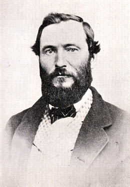
Charles Street originates in the 1876 plat of Plummer’s Addition to the City of Seattle, filed by George Washington Harris (late 1840s–1914).* How did Harris end up with the land, and why would he name the addition after Charles Plummer (who, it appears from the text of the plat description, bought the tract from David Swinson “Doc” Maynard in 1860)?
As it turns out: Plummer married Ellender Smith (sister of Dr. Henry A. Smith, namesake of Smith Cove and Smith Street) in 1855. Harris’s mother, Sarah Jane Crossman, was widowed the next year. Plummer himself became a widower when his wife died giving birth to twins Edward and Frank in 1859, and he married Harris’s mother in 1860, apparently at Maynard’s own Alki Point house. Harris then became Plummer’s stepson (and a daughter, Ida, was born to the newlyweds the next year). When Plummer died in 1866, Harris apparently inherited at least this much of his stepfather’s estate. (It’s unclear just what Edward and Ida may have received; Frank is reported to have inherited $60,000.)
Charles Plummer
Today, S Charles Street begins at Airport Way S and 6th Avenue S and is stopped a block and a half to the east at 7th Avenue S by the city’s Charles Street Service Center. (Its twin to the south, S Plummer Street, also ends at the service center, never to return.) It briefly reappears at the northern lip of Beacon Hill between 12th Avenue S and Sturgus Avenue S, and then east of Interstate 90 runs for about ⅓ of a mile between Poplar Place S and 20th Place S at Judkins Park. The right-of-way, which continues through the park, becomes an improved street again at 22nd Avenue S, and ends just east of 26th Avenue S. East of here, S Charles runs three blocks from 28th Avenue S to 30th Avenue S, and then around ¼ mile made up of alternating roadway and stairways from the alley west of 32nd Avenue S to a shoreline street end on Lake Washington — one of Leschi’s String of Pearls.
Note added October 23, 2023: S Charles Street now begins at 1st Avenue S and goes a block east to Occidental Avenue S, before resuming on the other side of Lumen Field at Airport Way S.
Born and raised in Seattle, Benjamin Donguk Lukoff had his interest in local history kindled at the age of six, when his father bought him settler granddaughter Sophie Frye Bass’s Pig-Tail Days in Old Seattle at the gift shop of the Museum of History and Industry. He studied English, Russian, and linguistics at the University of Washington, and went on to earn his master’s in English linguistics from University College London. His book of rephotography, Seattle Then and Now, was published in 2010. An updated version came out in 2015.
Because its original location is covered by King County Metro’s Atlantic Base and Interstate 5, Judkins Street now starts on Beacon Hill just west of 12th Avenue S and goes around 850 feet east to just east of 14th Avenue S, where it becomes a stairway to 15th Avenue S. The unimproved right-of-way continues through a greenbelt to 16th Avenue S, where there exists a 100-foot stretch of Judkins before it is stopped by Sturgus Avenue S, Daejon Park, and Interstate 90. On the other side of I-90, it resumes at 20th Avenue S and goes ⅘ of a mile east to Lake Washington Boulevard S, the last 50 or so feet being a stairway. Between Lake Washington Boulevard S and Lakeside Avenue S, only the first 150 feet is improved, mainly serving as a driveway for two houses. And east of Lakeside Avenue S there is a very short stretch that, like its neighbor to the north, S Norman Street, turns into a shoreline street end on Lake Washington — one of Leschi’s String of Pearls.
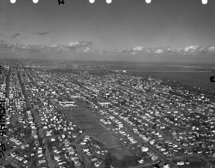
Built on the site of a former ravine landfill that was used for about four decades, Judkins Park was transferred to the parks department in the late 1940s and early 1950s, and opened to the public on October 8, 1977, according to a story in the October 6 issue of The Seattle Times.
Aerial view of Judkins Park and Playfield, 1965. Courtesy of the Seattle Municipal Archives, Identifier 29470. S Judkins Street is at bottom center and right, below the park. Washington Middle School is at the north end of the park and 23rd Avenue S is the arterial to its east. Lake Washington and the Evergreen Point Floating Bridge (Washington State Route 520) are visible in the distance.
Born and raised in Seattle, Benjamin Donguk Lukoff had his interest in local history kindled at the age of six, when his father bought him settler granddaughter Sophie Frye Bass’s Pig-Tail Days in Old Seattle at the gift shop of the Museum of History and Industry. He studied English, Russian, and linguistics at the University of Washington, and went on to earn his master’s in English linguistics from University College London. His book of rephotography, Seattle Then and Now, was published in 2010. An updated version came out in 2015.
For the origin of S Norman Street, we go back to our first street name post, SW Seattle Street, which read in part:
On August 4, 1869, Ike M. Hall — the executor of the estate of Norman B. Judkins — filed the Judkin’s (sic) Addition to the Town of Seattle, located just southwest of where the interchange between I-5 and I-90 is today. From north to south, the east–west streets are named Norman, B, Judkins, Addition, Town, and Seattle.
Today, S Norman Street begins on the other side of Beacon Hill, the portion shown above having been obliterated by King County Metro’s Atlantic Base and Interstate 5. (In fact, S Addition Street is the only one remaining in its original location, Judkins Street now starting on Beacon Hill and Seattle Street only existing in West Seattle.) Beginning at Poplar Place S just east of Interstate 90, it goes for a block northeast to Rainier Avenue S. It picks up again at Davis Place S and S Bush Place and goes a block east to 21st Avenue S. Resuming at 22nd Avenue S, just east of Judkins Park (also named for Norman B. Judkins), it goes ⅗ of a mile east to 33rd Avenue S, with only two short interruptions:
An unimproved stretch south of St. Gebriel Ethiopian Orthodox Church between 26th Avenue S and Martin Luther King Jr. Way S: what looks to be a bramble patch followed by a driveway for some townhouses; and
A stairway from 31st Avenue S to half a block west of 32nd Avenue S.
There appears to be a privately maintained stairway from 33rd Avenue S down to Lake Washington Boulevard S, and the next block is completely unimproved, though in both cases neighbors appear to be incorporating the right-of-way into their yards and driveways. Finally, there is a short stretch of Norman Street east of Lakeside Avenue S that turns into a shoreline street end on Lake Washington — one of Leschi’s String of Pearls.
King County Parcel Viewer showing S Norman Street between 26th Avenue S and Martin Luther King Jr. Way S. What appears to be a private driveway from Martin Luther King is actually public right-of-way.King County Parcel Viewer showing S Norman Street from 33rd Avenue S to Lake Washington. The private driveway in the public right-of-way east of Lake Washington Boulevard S (center of image) is easily visible, as is the shoreline street end east of Lakeside Avenue S.
Born and raised in Seattle, Benjamin Donguk Lukoff had his interest in local history kindled at the age of six, when his father bought him settler granddaughter Sophie Frye Bass’s Pig-Tail Days in Old Seattle at the gift shop of the Museum of History and Industry. He studied English, Russian, and linguistics at the University of Washington, and went on to earn his master’s in English linguistics from University College London. His book of rephotography, Seattle Then and Now, was published in 2010. An updated version came out in 2015.


.jpg)