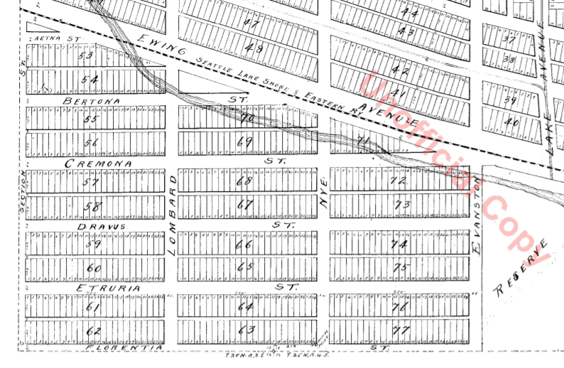
Florentia Street is the last in a series of streets, created in 1888 as part of Denny & Hoyt’s Addition to the City of Seattle, Washington Territory, that appear in alphabetical order and have the common theme of being locations in Italy. From north to south, they are Aetna, Bertona, Cremona, Dravus, Etruria, and Florentia. As can be seen in the plat map below, Florentia is not only the last in the series but the southern boundary of the plat itself.
Florentia is the Latin name of the city of Florence, known in Italian as Firenze.

Some detail in addition to that gone into in the post on Dravus Street:
- Aetna Street no longer exists, portions having been vacated in 1973 and 1974. Seattle Pacific University’s Royal Brougham Pavilion and Wallace Field now occupy the old right-of-way. Its name referred to Mt. Etna in Sicily, known in Latin as Aetna.
- More than half of Denny and Hoyt’s Addition is in what is now Fremont, north of the Fremont Cut of the Lake Washington Ship Canal, which was not finished until 1917. In a sense, this part of Queen Anne is more Fremont than Queen Anne. In the plat map above, the two are separated by Ross Creek and the Seattle, Lake Shore and Eastern Railway; the modern quarter section map covering the area shows nicely how the canal sliced through.
Florentia Street begins in the east at 4th Avenue N (the southern end of the Fremont Bridge) and goes ½ a mile west to 3rd Avenue W.
Born and raised in Seattle, Benjamin Donguk Lukoff had his interest in local history kindled at the age of six, when his father bought him settler granddaughter Sophie Frye Bass’s Pig-Tail Days in Old Seattle at the gift shop of the Museum of History and Industry. He studied English, Russian, and linguistics at the University of Washington, and went on to earn his master’s in English linguistics from University College London. His book of rephotography, Seattle Then and Now, was published in 2010. An updated version came out in 2015.
