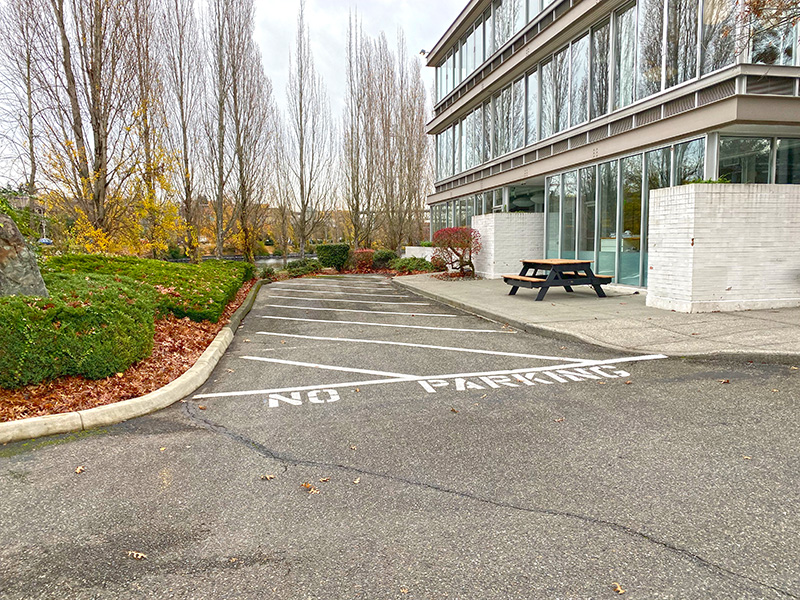
Florentia Street

Florentia Street is the last in a series of streets, created in 1888 as part of Denny & Hoyt’s Addition to the City of Seattle, Washington Territory, that appear in alphabetical order and have the common theme of being locations in Italy. From north to south, they are Aetna, Bertona, Cremona, Dravus, Etruria, and Florentia. As can be seen in the plat map below, Florentia is not only the last in the series but the southern boundary of the plat itself.

Florentia is the Latin name of the city of Florence, known in Italian as Firenze.
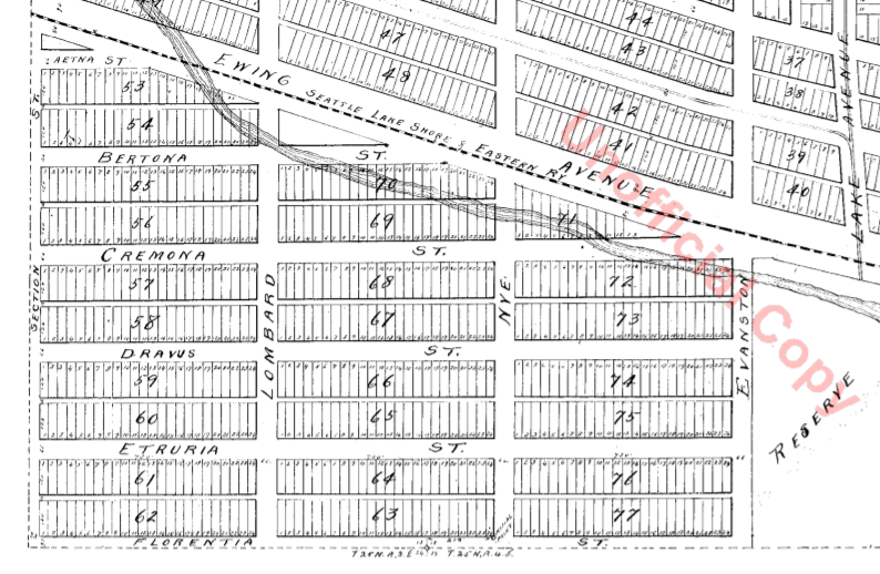
Portion of plat map of Denny and Hoyt's Addition to the City of Seattle, Washington Territory (1888) showing Aetna, Bertona, Cremona, Dravus, Etruria, and Florentia Streets
Portion of plat map of Denny and Hoyt’s Addition to the City of Seattle, Washington Territory (1888) showing Aetna, Bertona, Cremona, Dravus, Etruria, and Florentia Streets

Some detail in addition to that gone into in the post on Dravus Street:

Florentia Street begins in the east at 4th Avenue N (the southern end of the Fremont Bridge) and goes ½ a mile west to 3rd Avenue W.

Etruria Street

Etruria Street is another one of those streets created in 1888 as part of Denny & Hoyt’s Addition to the City of Seattle, Washington Territory, part of a series — Aetna, Bertona, Cremona, Dravus, Etruria, and Florentia — that appear in alphabetical order and have the common theme of being locations in Italy. Etruria, the land of the ancient Etruscans, was located in what is now the regions of Tuscany, Lazio, and Umbria, northwest of Rome.

Etruria Street begins in the east at the Ship Canal Trail and 3rd Avenue N, and goes just over ⅖ of a mile west to 3rd Avenue W. It resumes east of 8th Avenue W at a Seattle Pacific University parking lot and goes a further ¼ of a mile west to 10th Avenue W.


Cremona Street

Cremona Street is another street created in 1888 as part of Denny & Hoyt’s Addition to the City of Seattle, Washington Territory, part of a series of streets — Aetna, Bertona, Cremona, Dravus, Etruria, and Florentia — that appear in alphabetical order and have the common theme of being locations in Italy. Cremona, or Cremùna in the local dialect, is a city in Lombardy, perhaps best known for its luthiers, most notably Antonio Stradivari.

Cremona Street begins in the east at the Ship Canal Trail and goes ¼ of a mile west to 3rd Avenue W and the entrance to Seattle Pacific University. On the other side of campus it goes a further ⅕ of a mile west from 6th Avenue W to 9th Avenue W.

W Bertona Street

This street, as with Dravus Street, was created in 1888 as part of Denny & Hoyt’s Addition to the City of Seattle, Washington Territory, and is also is part of a series of streets — Aetna, Bertona, Cremona, Dravus, Etruria, and Florentia — that appear in alphabetical order and have the common theme of being locations in Italy. Montebello di Bertona (Mundibbèlle in the Abruzzese dialect) is a small town in Pescara, Abruzzo, located near Mt. Bertona.

Technically, W Bertona Street begins as Bertona Street at the Ship Canal Trail around 80 feet east of Queen Anne Avenue N, but both streets there are little more than parking aisles nestled up against Seattle Pacific University’s Wallace Field. W Bertona begins in earnest at W Nickerson Street and goes ¾ of a mile west to 14th Avenue W, where it becomes a block-long stairway to 15th Avenue W. On the other side of 15th, it goes two more blocks before being stopped by the BNSF Railway tracks at 17th Avenue W; on the other side of the tracks it goes ⅗ of a mile west from 20th Avenue W to 30th Avenue W, becoming a stairway again for a block just about halfway. As with its Magnolia partner W Dravus Street, it’s ⅓ of a mile from 31st Avenue W to 36th Avenue W, where it becomes a stairway for a block, and then ½ a mile more from 37th Avenue W to 45th Avenue W. There is finally a 300-foot-long segment west of Perkins Lane W, where the roadway ends. (There is a shoreline street end beyond that, but it is currently inaccessible.)

Bertona Street east of Queen Anne Avenue N, November 2021
Bertona Street east of Queen Anne Avenue N, November 2021. The 2 Nickerson Street office building is at right; the row of trees is between the Ship Canal Trail and the Fremont Cut. Fremont and the Aurora Bridge are visible in the distance. Photograph by Benjamin Lukoff. Copyright © 2021 Benjamin Lukoff. All rights reserved.

Dravus Street

This street was created in 1888 as part of Denny & Hoyt’s Addition to the City of Seattle, Washington Territory by Edward Blewett and his wife, Carrie, of Fremont, Nebraska, who had purchased the land a few months earlier from Arthur Denny and John Hoyt. According to Valarie Bunn in her article “Fremont in Seattle: Street Names and Neighborhood Boundaries,” Edward Corliss Kilbourne may have done much of the actual naming of streets as attorney-in-fact for the Blewetts.

Portion of plat map of Denny and Hoyt's Addition to the City of Seattle, Washington Territory (1888) showing Aetna, Bertona, Cremona, Dravus, Etruria, and Florentia Streets
Portion of plat map of Denny and Hoyt’s Addition to the City of Seattle, Washington Territory (1888) showing Aetna, Bertona, Cremona, Dravus, Etruria, and Florentia Streets

As can be seen in the plat map above, Dravus is part of a series of streets — Aetna, Bertona, Cremona, Dravus, Etruria, and Florentia — that appear in alphabetical order and have the common theme of being locations in Italy, which had been unified 17 years earlier. I have yet to find a connection between Denny, Hoyt, the Blewetts, or Kilbourne and Italy. The closest I’ve come is an item in the February 28, 1903, issue of The Seattle Mail and Herald, which reports that “on February 27, the Woman’s Century Club met and discussed the subject ‘Italian Art and Literature.’ Mrs. Bessie L. Savage and Mrs. E.C. Kilbourne [Leilla Shorey] prepared papers relating to these subjects.” I would love to find out if there’s anything more solid!

The Drava River, which originates in the Italian region of the South Tyrol, flows from there through Austria, Slovenia, and Croatia, forming much of the border between that country and Hungary, and joining the Danube on the Croatia–Serbia border. It was known as Dravus in Latin and Δράβος in Greek.

Dravus Street begins in the east at Nickerson Street and goes ⅗ of a mile west to 8th Avenue W and Conkling Place W. It resumes for half a block at 10th Avenue W, is briefly a foot path and stairway, and then is an arterial connecting Queen Anne and Magnolia via Interbay, going just over a mile from 11th Avenue W to 30th Avenue W. (This section was originally known as Grand Boulevard, and indeed W Dravus is double the width of the other streets in the area, though it features wide planting strips instead of a central median.) It’s ⅓ of a mile from 31st Avenue W to 36th Avenue W, where it becomes a stairway for a block, and then ½ a mile more from 37th Avenue W to just west of Magnolia Boulevard W, where the roadway ends. (There is a shoreline street end off Perkins Lane W, but it is currently inaccessible.)