NE Radford Drive

It isn’t often that a vintage newspaper article explicitly states the reason behind a new street’s naming, but when it comes to Radford Drive, we’re in luck. On November 30, 1940, the Seattle Post-Intelligencer reported, under the headline ‘Work started at Sand Point Homes project’, that ground had been broken the day before on a project to house 150 enlisted men, plus their families, from the adjacent Sand Point Naval Air Station. (The project was said to cost $620,000, which is ¾ of the average price of a single home in Seattle today!) Rather amusingly, the air station’s commandant, Captain Ralph Wood, is quoted as saying “the days when the sailor was a bachelor and a derelict have long since passed” as justification for the need for military family housing. The article goes on to say that:

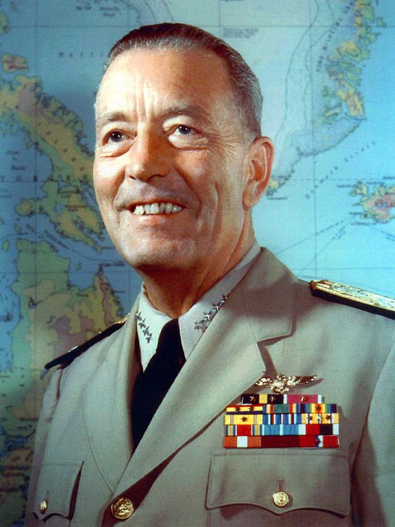
Street entrance to the area will be named Radford Drive in honor of Commander Arthur W. Radford, former commandant of the Sand Point base, who launched the expansion program which has resulted in its present growth.

Arthur W. Radford (1896–1973), who had been appointed commandant in 1939, was promoted to captain in 1942 and to rear admiral in 1943. He became vice admiral in 1945, and was appointed by President Harry S. Truman as vice chief of naval operations in 1948. In 1949, he was made high commissioner of the Trust Territory of the Pacific Islands as well as commander-in-chief of the U.S. Pacific Fleet, and in 1953 he became President Dwight D. Eisenhower’s selection as chairman of the Joint Chiefs of Staff. He retired from the Navy in 1957.

Admiral Arthur W. Radford

Today, the housing complex, redeveloped in 2001, is known as Radford Court, and is owned by the University of Washington, though some units are available to the public. Interestingly, the entrance to the neighborhood from NE 65th Street is signed Radford Drive NE and is on University-owned land, while the publicly owned street is legally NE Radford Drive, but not signed at all — and the addresses for the complex are on 65th Avenue NE (one of the city streets, the other being NE 64th Street, that connects directly to the property).*

* Yes, NE 65th Street and 65th Avenue NE intersect here. Because of how Seattle’s street naming system works, Windermere and Laurelhurst are the site of a number of similar intersections, including those for 60th, 59th, 57th, 55th, 54th, 50th, 47th, 45th, 43rd, 41st, and 40th.

Newton Street

This street originates in the 1882 plat of Bigelow’s Addition to the City of Seattle, filed by Jesse W. George (1835–1895) and Cassandra Eckler George (1840–1920) at the request of Isaac Newton Bigelow (1838–1922). As the Queen Anne Historic Context Statement explains,

In the early 1870s, the Denny and Mercer families gradually began to systematically subdivide their large land holdings on the south and east slopes of Queen Anne Hill. When a severe windstorm blew down thousands of trees in the north district in 1875, views opened up and land seekers turned their attentions beyond Belltown. Real estate speculators new to the territory arrived and began to buy up property on the crest of Queen Anne Hill. Some of these speculators also became developers, such as George Kinnear, or builder-developers, such as Isaac Bigelow.

Though its proximity to Boston and Lynn Streets suggest a tribute to Newton, Massachusetts, neither the Georges nor the Bigelows appear to have a connection to the state, so it seems this one should be chalked up to Isaac Bigelow’s middle name.

Today, Newton Street begins in Magnolia as W Newton Street at 30th Avenue W, and goes nearly half a mile east to 23rd Avenue W. There is then a two-block stretch from 15th Avenue W to 13th Avenue W in Interbay, and then the “original” Newton Street, which stretches almost a half mile from 1st Avenue N to Taylor Avenue N, followed by another two-block stretch from Dexter Avenue N to just past 8th Avenue N. On the east side of Lake Union, E Newton Street picks up again at Terry Pettus Park, just west of Fairview Avenue E, and goes ¼ mile to Boylston Avenue E and Lakeview Boulevard E. There follows another ¼-mile stretch from Broadway E to Everett Avenue E. East of there, Newton exists in a number of short segments through Montlake, and then enjoys a run of ⅓ of a mile from 37th Place E to 43rd Avenue E in Madison Park. 

Blanchard Street

For Blanchard Street, I can do no better than to quote Sophie Frye Bass, who in Pig-Tail Days in Old Seattle writes:

The name of Blanchard Street had long been a puzzle to me, but when I looked over some records of 1872 and found where John M. Blanchard had been one of the witnesses when my grandfather, Arthur Denny, platted a tract of land, then I knew.

Blanchard Street was part of A.A. Denny’s 6th Addition to the City of Seattle, filed in 1873, and indeed John M. Blanchard is one of the witnesses, along with Duncan T. Wheeler. Blanchard appears to have been city treasurer in 1879, as well as an insurance agent. Wheeler is referred to in 1871 as being a merchant, and in 1874 he and Blanchard apparently attended a masquerade ball dressed as members of the Ku Klux Klan(!), predating the establishment of an actual Klan chapter by half a century. (Their wives went as a “Canadian Squaw” and the “Queen of Chess,” respectively.)

Today, Blanchard Street begins at Elliott Avenue and goes just over half a mile to the northwest, where it ends at Westlake Avenue.

S Plummer Street

S Plummer Street, like S Charles Street, was created as part of the 1876 plat of Plummer’s Addition to the City of Seattle, and was named by George Washington Harris after his late stepfather, Charles Plummer, who had died 10 years earlier.

Charles Plummer
Charles Plummer

Unlike S Charles Street, which makes it all the way to Lake Washington, S Plummer Street runs a mere block from Airport Way S and Maynard Avenue S in the west to 7th Avenue S in the east, where it is stopped by the city’s Charles Street Service Center.

S Charles Street

Charles Street originates in the 1876 plat of Plummer’s Addition to the City of Seattle, filed by George Washington Harris (late 1840s–1914).* How did Harris end up with the land, and why would he name the addition after Charles Plummer (who, it appears from the text of the plat description, bought the tract from David Swinson “Doc” Maynard in 1860)?

* I write “late 1840s” because Harris’s birth year is given variously as 1848 (death certificate, historical journal article, Tacoma Public Library), 1847 (Genealogy.com, The Seattle Times), and 1846 (Geni, FamilySearch). 

As it turns out: Plummer married Ellender Smith (sister of Dr. Henry A. Smith, namesake of Smith Cove and Smith Street) in 1855. Harris’s mother, Sarah Jane Crossman, was widowed the next year. Plummer himself became a widower when his wife died giving birth to twins Edward and Frank in 1859, and he married Harris’s mother in 1860, apparently at Maynard’s own Alki Point house. Harris then became Plummer’s stepson (and a daughter, Ida, was born to the newlyweds the next year). When Plummer died in 1866, Harris apparently inherited at least this much of his stepfather’s estate. (It’s unclear just what Edward and Ida may have received; Frank is reported to have inherited $60,000.)

Charles Plummer
Charles Plummer

Today, S Charles Street begins at Airport Way S and 6th Avenue S and is stopped a block and a half to the east at 7th Avenue S by the city’s Charles Street Service Center. (Its twin to the south, S Plummer Street, also ends at the service center, never to return.) It briefly reappears at the northern lip of Beacon Hill between 12th Avenue S and Sturgus Avenue S, and then east of Interstate 90 runs for about ⅓ of a mile between Poplar Place S and 20th Place S at Judkins Park. The right-of-way, which continues through the park, becomes an improved street again at 22nd Avenue S, and ends just east of 26th Avenue S. East of here, S Charles runs three blocks from 28th Avenue S to 30th Avenue S, and then around ¼ mile made up of alternating roadway and stairways from the alley west of 32nd Avenue S to a shoreline street end on Lake Washington — one of Leschi’s String of Pearls.

Note added October 23, 2023: S Charles Street now begins at 1st Avenue S and goes a block east to Occidental Avenue S, before resuming on the other side of Lumen Field at Airport Way S.

S Judkins Street

S Judkins Street, like S Norman Street, S Addition Street, and SW Seattle Street, was named in the 1869 plat of Judkin’s (sic) Addition to the Town of Seattle, whose street names were, from north to south, Norman, B, Judkins, Addition, Town, and Seattle.

Plat of Judkin's Addition to the Town of Seattle

Because its original location is covered by King County Metro’s Atlantic Base and Interstate 5, Judkins Street now starts on Beacon Hill just west of 12th Avenue S and goes around 850 feet east to just east of 14th Avenue S, where it becomes a stairway to 15th Avenue S. The unimproved right-of-way continues through a greenbelt to 16th Avenue S, where there exists a 100-foot stretch of Judkins before it is stopped by Sturgus Avenue S, Daejon Park, and Interstate 90. On the other side of I-90, it resumes at 20th Avenue S and goes ⅘ of a mile east to Lake Washington Boulevard S, the last 50 or so feet being a stairway. Between Lake Washington Boulevard S and Lakeside Avenue S, only the first 150 feet is improved, mainly serving as a driveway for two houses. And east of Lakeside Avenue S there is a very short stretch that, like its neighbor to the north, S Norman Street, turns into a shoreline street end on Lake Washington — one of Leschi’s String of Pearls.

Judkins Street gives its name to Judkins Park and Playfield, which stretches for a number of blocks north of S Judkins Street and 22nd Avenue S, as far as Washington Middle School. The land between S Judkins Street and Interstate 90 through which the I-90 Trail winds (part of the Mountains to Sound Greenway) is also sometimes considered to be part of Judkins Park. The park, in turn, gives its name to the neighborhood of Judkins Park, and to the future Judkins Park station of Sound Transit’s Line 2 extension to the Eastside.

Built on the site of a former ravine landfill that was used for about four decades, Judkins Park was transferred to the parks department in the late 1940s and early 1950s, and opened to the public on October 8, 1977, according to a story in the October 6 issue of The Seattle Times.

Aerial view of Judkins Park and Playground, 1965
Aerial view of Judkins Park and Playfield, 1965. Courtesy of the Seattle Municipal Archives, Identifier 29470. S Judkins Street is at bottom center and right, below the park. Washington Middle School is at the north end of the park and 23rd Avenue S is the arterial to its east. Lake Washington and the Evergreen Point Floating Bridge (Washington State Route 520) are visible in the distance.

S Norman Street

For the origin of S Norman Street, we go back to our first street name post, SW Seattle Street, which read in part:

On August 4, 1869, Ike M. Hall — the executor of the estate of Norman B. Judkins — filed the Judkin’s (sic) Addition to the Town of Seattle, located just southwest of where the interchange between I-5 and I-90 is today. From north to south, the east–west streets are named Norman, B, Judkins, Addition, Town, and Seattle.

Plat of Judkin's Addition to the Town of Seattle

Today, S Norman Street begins on the other side of Beacon Hill, the portion shown above having been obliterated by King County Metro’s Atlantic Base and Interstate 5. (In fact, S Addition Street is the only one remaining in its original location, Judkins Street now starting on Beacon Hill and Seattle Street only existing in West Seattle.) Beginning at Poplar Place S just east of Interstate 90, it goes for a block northeast to Rainier Avenue S. It picks up again at Davis Place S and S Bush Place and goes a block east to 21st Avenue S. Resuming at 22nd Avenue S, just east of Judkins Park (also named for Norman B. Judkins), it goes ⅗ of a mile east to 33rd Avenue S, with only two short interruptions:

  • An unimproved stretch south of St. Gebriel Ethiopian Orthodox Church between 26th Avenue S and Martin Luther King Jr. Way S: what looks to be a bramble patch followed by a driveway for some townhouses; and
  • A stairway from 31st Avenue S to half a block west of 32nd Avenue S.

There appears to be a privately maintained stairway from 33rd Avenue S down to Lake Washington Boulevard S, and the next block is completely unimproved, though in both cases neighbors appear to be incorporating the right-of-way into their yards and driveways. Finally, there is a short stretch of Norman Street east of Lakeside Avenue S that turns into a shoreline street end on Lake Washington — one of Leschi’s String of Pearls

King County Parcel Viewer showing S Norman Street at Martin Luther King Jr. Way S
King County Parcel Viewer showing S Norman Street between 26th Avenue S and Martin Luther King Jr. Way S. What appears to be a private driveway from Martin Luther King is actually public right-of-way.
King County Parcel Viewer showing S Norman Street from 33rd Avenue S to Lake Washington
King County Parcel Viewer showing S Norman Street from 33rd Avenue S to Lake Washington. The private driveway in the public right-of-way east of Lake Washington Boulevard S (center of image) is easily visible, as is the shoreline street end east of Lakeside Avenue S.

Loyal Avenue NW

Loyal Avenue NW, named by Edward B. Cox, Harry Whitney Treat (1865–1922), and Treat’s wife, Olive Marion Graef Treat (1869–1945) in the 1907 plat of Loyal Heights, was named, as was the subdivision and Loyal Way NW, after the Treats’ newborn daughter, Loyal Graef Treat Nichols (1906–2004). It connects Golden Gardens Drive NW to View Avenue NW and is just over 850 feet long.

Priscilla Van Sickler and Loyal Nichols at the Olympic Riding and Driving Club, Seattle, 1932
Loyal Graef Treat Nichols (right) and her elder sister, Priscilla Grace Treat Van Sickler, at the Olympic Riding and Driving Club, Seattle, 1932

E Louisa Street

Louisa Street was named for Louisa Boren Denny (1827–1916), who was 24 years old when she and her future husband David Thomas Denny (1832–1903) arrived in Seattle as part of the Denny Party. Their marriage in 1853 was the first in King County. The street name originates in the 1890 plat of the Denny-Fuhrman Addition to the City of Seattle, filed by the Dennys, Henry Fuhrman (Fuhrman Avenue E), and his wife, Carrie Fuhrman.

Daguerreotype portrait of Louisa Boren Denny, no date
Undated daguerreotype portrait of Louisa Boren Denny

Today, E Louisa Street begins at Minor Avenue E and goes a block east to Yale Avenue E. It resumes half a block east at the alley west of Eastlake Avenue E and makes it 2½ blocks before being stopped by Interstate 5 at Boylston Avenue E. Resuming in the Montlake neighborhood just west of W Montlake Place E, it then goes ¼ mile east to 25th Avenue E.

Bishop Place W

This Magnolia street, which goes not quite 700 feet from 37th Avenue W just south of W Armour Street in the south to W Fulton Street just west of 36th Avenue W in the north, originated in 1939 as part of the plat of Carleton Park Terrace, an Addition to the City of Seattle, filed by C.F. Bishop, Jr., his wife, Elizabeth, and the city of Seattle itself, owners of the land in question.

Charles F. Bishop, Jr. (1881–1963) was — according to his Seattle Post-Intelligencer and Seattle Times obituaries, and based on information in his father’s Times obituary from 1943 — born in Brockport, New York, near Rochester, and came to Seattle when he was 18. The elder Bishop was a marine engineer for the Alaska Steamship Company and the Puget Sound Navigation Company. Bishop Jr. was a grocery wholesaler who ran the Puget Sound Quality Stores (PSQ Stores) cooperative, which, according to local historian Paul Dorpat in his April 6, 1986 Now & Then column for the P-I, was a predecessor of Associated Grocers — now, after a number of mergers and acquisitions, part of United Natural Foods

Bishop founded Modern Home Builders, Inc., with his brother, Ralph Waldo Bishop, Sr., in 1940, the year after he filed the plat of Carleton Park Terrace. This particular plat of his carried no racial restrictive covenants, but the adjacent Carleton Park Terrace Division № 3, filed in 1941, did, banning non-whites from living in the subdivision unless they were domestic servants of white residents.

Lawtonwood Road

Lawtonwood Road is one of the many Magnolia streets, like W Government Way, W Fort Street, and W Lawton Street, related to Fort Lawton, which was opened by the U.S. Army in 1900 and is now Discovery Park. (The fort itself was named for Major General Henry Ware Lawton [1843–1899]). It runs ⅓ of a mile northwest from 40th Avenue W to the intersection of 45th Avenue W and W Cramer Street.

Street sign at the corner of Lawtonwood Road, W Lawton Street, and 40th Avenue W, October 30, 2011
Street sign at the corner of Lawtonwood Road, W Lawton Street, and 40th Avenue W. Photograph by Benjamin Lukoff, October 30, 2011. Copyright © 2011 Benjamin Lukoff. All rights reserved.

The neighborhood of Lawtonwood, or Lawton Wood — both spellings have been in use over the years — is perched atop Discovery Park north of W Cramer Street. Lawtonwood Road, which goes through the park, is the only way in or out. It would have been a natural part of Fort Lawton, and it certainly would have made a great addition to the park, but as local historian Paul Dorpat explains in his introduction to the neighborhood

Steady white settlement started in 1875 when German immigrant Christian Scheuerman moved to the area, cleared the timber and married a native woman who had ten children before she died in 1884. In 1895 Seattle boosters organized to attract a military post to the area and gathered the acreage that is now Fort Lawton–Discovery Park. The part of it that is now Lawton Wood… is not part of the military holding because Scheuerman withheld it.

It should not be thought that Scheuerman cared nothing at all for the defense of Seattle — he and his family did donate 26.13 acres to the cause — though that made up less than 4% of the 704.21 acres given in total. (The single largest contributors of land were Thomas W. Prosch and his wife, Virginia, who gave 330.97 acres, a full 47%.)

Dorpat continues:

Soon after the military moved in next door, this protected enclave was improved with mansions of a few of Seattle’s elite. In 1952 these neighbors — about 30 houses sparingly distributed about a generous 30 acres – organized the Lawton Wood Improvement Club, waving the motto “To Beautify and Develop Lawton Wood.” By the time that the last of the Scheuermans, Ruby, moved out in the late 1970s, the beautifying had turned more to developing, and the lots got smaller.

The first reference to Lawtonwood Road I was able to find in The Seattle Times or the Seattle Post-Intelligencer is from 1935, but it does not appear to have been officially so designated until 2007. According to ordinance 122503, park roads “are considered ‘private’” — technically residents of Lawtonwood and Bay Terrace had no legal right to transit the park to reach their homes, though of course they had never been prevented from doing so. To rectify this and other issues, and in anticipation of the privatization of the residences on Officers’ Row and Montana Circle, the ordinance made Lawtonwood Road, Bay Terrace Road, Utah Street, Washington Avenue, California Avenue, Iowa Street, Illinois Avenue, Texas Way, Idaho Avenue, and 45th Avenue W “public park boulevards.”

Note, by the way, that none of these streets except 45th Avenue W contain a directional designation. Ordinarily one would expect to see W Lawtonwood Road, or Lawtonwood Road W, but park roads in Seattle carry no directional designation. An exception seems to have been made for 45th Avenue W, presumably because a numbered avenue with no directional designation “belongs” in Madrona or Leschi, seven miles to the southeast.

Scheuerman Creek just east of 45th Avenue W in the Lawtonwood neighborhood. 45th Avenue W is part of Discovery Park, but the creek is on private property. Photograph by Benjamin Lukoff, January 31, 2021. Copyright © 2021 Benjamin Lukoff. All rights reserved.
Scheuerman Creek just east of 45th Avenue W in the Lawtonwood neighborhood. As noted above, 45th Avenue W is part of Discovery Park, but the creek is on private property. Photograph by Benjamin Lukoff, January 31, 2021. Copyright © 2021 Benjamin Lukoff. All rights reserved.

W Lawton Street

Lawton Street originated as Lawton Place in the 1905 plat of Lawton Park, an Addition to the City of Seattle. Like Government Way and Fort Street, it was named for its proximity to Fort Lawton, which had been opened by the U.S. Army in 1900. The fort itself was named for Major General Henry Ware Lawton (1843–1899), who was killed in December 1899 in the Battle of Paye of the Philippine–American War.

The bulk of W Lawton Street comes not from the Lawton Park plat, which covered 34th Avenue W to 36th Avenue W, but from a grant from the federal government in 1909 for sewer and street purposes. Lawton Street was laid out along the north edge of the fort, from its northwest corner at 36th Avenue W to what is now 40th Avenue W. There is a short discontinuity beginning about 250 feet east of 40th Avenue W consisting of a footpath and stairs; I’m not sure when that was created, but I don’t think it was the original configuration, as that would have defeated the purpose of the street.


Perkins Lane W

This Magnolia street boasts one of the best views in all of Seattle — a completely unobstructed vista of Elliott Bay, Puget Sound, the Kitsap Peninsula, and the Olympic Mountains — if you’re fortunate enough to own property there. The view from the street itself is mostly of houses to the west, forested slope to the east. Notable Seattleites such as developer Martin Selig, broadcaster Kathi Goertzen, musician Ryan Lewis, and co-founder of Starbucks and Redhook Ale Brewery Gordon Bowker have called the winding lane — and it truly is a winding lane, hugging the bluff with barely enough room for two cars to pass each other — home.

View of Perkins Lane, Elliott Bay, and West Seattle from Discovery Park
View of Perkins Lane houses from Discovery Park, with Elliott Bay and West Seattle in background, January 2021. Photograph by Joe Mabel, Wikimedia Commons, licensed under Creative Commons Attribution-ShareAlike 4.0 International

The street was created as part of Carleton Beach Tracts, an Addition to the City of Seattle, Washington, on New Year’s Eve, 1920. The owners were Arthur Alexander Phinney (1885–1941), son of Guy Carleton Phinney, after whom Phinney Ridge and Phinney Avenue N are named; his wife, Daisy Euphemia Phinney (1884–1950); the Phinney Realty and Investment Company; and Oscar E. Jensen & Co., Inc. It begins at W Emerson Street in the north, just south of Discovery Park, and goes 1⅖ miles southeast to a roadblock a few feet beyond the bottom of the Montavista Stairs (more on that later). The roadway continues about 250 feet past the roadblock — all the buildings and lots on the west side belong to Martin Selig — and the right-of-way continues a little over 800 feet beyond that (see below for why).

The lane’s namesake had been a mystery to me for a long time, until I came across the Phinneys’ wedding announcement in the May 11, 1913, issue of the Seattle Post-Intelligencer:

Formal announcement made yesterday of the marriage at Victoria, B.C., May 2, of Miss Daisy E. Perkins, of Portland, to Mr. Arthur A. Phinney, of Seattle, contained the first intimation to local friends of Mr. Phinney of the nuptial event. The bride and groom had laid their plans in secret and protected this secret against all inquiring friends.

It seems, then, that we have a case similar to that of Thorndyke Avenue W — naming a prominent street after the wife’s maiden name.

For all its advantages, though — view, privacy (though it’s a public street, there are only a couple of ways to drive there from the rest of the city, plus two rickety staircases down from Magnolia Boulevard) — Perkins Lane has its faults, as the headline ‘Perkins Lane: Seattle’s Poster Child for Landslide Risk’ implies. A major landslide at the end of 1996 took out five or six houses, depending on whom you ask, at the southeast end of the street, and the adjoining roadway — hence the aforementioned roadblock. A lawsuit against the city, of course, was filed, but was dismissed at summary judgment. Slides had been a problem for the seven decades of Perkins Lane’s existence before that, as the images below attest. (The statute of limitations for false advertising has long elapsed, alas…)

Perkins Lane Slide at W. Ray St. (displacement of utility poles), March 22 1925, from https://archives.seattle.gov/digital-collections/index.php/Detail/objects/77613, Seattle Municipal Archives Identifier 38072
Landslide at W Raye Street, with tilting utility pole, March 22, 1925. Courtesy of the Seattle Municipal Archives, Identifier 38072
Sign reading "For sale by owner — best buy, best view on Perkins Lane — No slides — Civil engineer says "Good condition to build on" — ME. 3843, MA. 8847 — 150 ft. frontage — will divide" at 2461 Perkins Lane W
Land for sale! Who was that civil engineer, I wonder…
“No slides — Civil engineer says ‘Good condition to build on,’” 2461 Perkins Lane W, April 14, 1938. Courtesy of the Seattle Municipal Archives, Identifier 12194
Landslide at 2445 Perkins Lane W
Landslide at 2445 Perkins Lane W, January 27, 1954. Courtesy of the Seattle Municipal Archives, Identifier 44997
Ruins of house destroyed in Perkins Lane landslide on Magnolia beach in front of Magnolia bluff
Ruins of house destroyed in Perkins Lane landslide on Magnolia beach in front of Magnolia bluff, Photograph by Flickr user Whitney H, licensed under Creative Commons Attribution-NonCommercial-NoDerivs 2.0 Generic

In fact, as the map below shows, there have been numerous slides over the years along the entire length of the road.

Perkins Lane W is also home to six of Seattle’s shoreline street ends — at W Bertona, Dravus, Barrett, Armour, Raye, and McGraw Streets, though McGraw is the only one currently accessible from land. The project to improve it back in 2013 and 2014 was not without opposition, but ultimately the threats never materialized (nor did the opponents’s fears). It’s well worth a visit.

View looking south from the W McGraw street end: Elliott Bay, Puget Sound, and West Seattle
View looking southeast from the W McGraw street end: Elliott Bay, Puget Sound, and West Seattle, November 5, 2014. Photograph by Flickr user Seattle Parks and Recreation, licensed under Creative Commons Attribution 2.0 Generic
Fourmile Rock by Wikimedia Commons user Dennis Bratland, from https://commons.wikimedia.org/wiki/File:Fourmile_Rock,_Magnolia_at_low_tide,_with_yardstick.JPG, licensed under https://creativecommons.org/licenses/by-sa/4.0/deed.en, April 6, 2015
Fourmile Rock (native name reportedly LE’plEpL, La’pub, or Tc!ě’tla), northwest of the W McGraw street end, April 6, 2015. Photograph by Dennis Bratland, Wikimedia Commons, licensed under Creative Commons Attribution-ShareAlike 4.0 International

Maynard Alley S

Maynard Alley, one of the few named alleys in Seattle, goes just under ¼ mile from S Jackson Street in the north to S Dearborn Street in the south between Maynard Avenue S and 7th Avenue S. Like Maynard Avenue, it was named for David Swinson “Doc” Maynard, who is generally credited with naming the town of Seattle, after his friend siʔaɫ, or Chief Seattle, and was its “first physician, merchant, Indian agent, and justice of the peace.”

Maynard Alley sign, Seattle, 2010
Maynard Alley sign in front of Washington State Acupuncture and Chinese Medicine Center on S King Street, 2010. Photograph by Joe Mabel, Wikimedia Commons, licensed under Creative Commons Attribution-ShareAlike 3.0 Unported

Even though it had been named that for years, and was signed as such, its name was not officially made Maynard Alley S until 2019, so that addresses from which 911 calls were coming could be more easily located and emergency vehicle response times could be reduced. (The same thing was done for Canton Alley S, a block to the east, as part of the same ordinance.)

(The earliest reference I can find to Maynard Alley in The Seattle Star, The Seattle Times, or the Seattle Post-Intelligencer is an article in the March 30, 1910, issue of the P-I.)

Portion of Summary and Fiscal Note to Seattle Ordinance 125753 Regarding Maynard Alley S, from https://clerk.seattle.gov/search/ordinances/125753
Portion of summary and fiscal note to ordinance 125753 regarding Maynard Alley S

S Royal Brougham Way

This street begins at Colorado Avenue S in the west, at an onramp to the northbound lanes of the State Route 99 tunnel, and goes ⅔ of a mile east to Airport Way S. Originally S Connecticut Street, it was renamed in 1979 in honor of sportswriter Royal Brougham (1894–1978), who worked for the Seattle Post-Intelligencer newspaper from 1910 until his death. Such a name change was formally proposed by city councilman George Benson following a suggestion by P-I columnist Emmett Watson. Originally it was to be Occidental Avenue S whose name was to be changed, then the 2nd Avenue S Extension when objections were raised. Finally S Connecticut Street was settled upon; it was thought to be particularly appropriate because he “worked so hard to see the Kingdome built… and eventually spent his last day on earth there.”

Lumen Field, built on the former Kingdome site, is on the north side of Royal Brougham between 1st Avenue S and 4th Avenue S; and T-Mobile Park is on the south side between 1st Avenue S and 3rd Avenue S.

Royal Brougham's ID card for the Seattle Post-Intelligencer newspaper, 1925
Royal Brougham’s Seattle P-I staff ID card, 1925

S Roberto Maestas Festival Street

This street, formerly the 1600 block of S Lander Street, runs between 16th and 17th Avenues S on Beacon Hill, north of the Beacon Hill light rail station and south of the Plaza Roberto Maestas housing development of El Centro de la Raza, a social service agency. It was renamed in 2011 in honor of Roberto Maestas (1938–2010), who co-founded El Centro in 1972 in the recently closed Beacon Hill Elementary School.

Roberto Maestas, 2008
Roberto Maestas, 2008. Photograph by Joe Mabel, Wikimedia Commons, licensed under Creative Commons Attribution-Share Alike 3.0 Unported

The street is one of a number of “festival streets” in the city of Seattle: “designated portions of streets intended for frequent public events.” E Barbara Bailey Way is the other one we’ve covered so far.

Sign at corner of S Roberto Maestas Festival Street and 17th Avenue S, October 1, 2011
Signs at corner of S Roberto Maestas Festival Street and 17th Avenue S, October 1, 2011. Photograph by Benjamin Lukoff. Copyright © 2011 Benjamin Lukoff. All rights reserved.

Mary Gates Memorial Drive NE

This street, which runs ⅕ of a mile from the “five corners” intersection with NE 45th Street, NE 45th Place, and Union Bay Place NE in the northwest to NE 41st Street in the southeast, was created in 1911 as an extension of Union Bay Place. It was renamed in 1995 in honor of Mary Maxwell Gates (1929–1994), mother of Microsoft co-founder Bill Gates and a member of the University of Washington Board of Regents from 1975 to 1993.

The original proposal was to also change the name of NE 41st Street between Union Bay Place NE and Surber Drive NE to NE Mary Gates Memorial Drive, but this was not done. An article in the March 14, 1995, issue of The Seattle Times reports that “City Councilwoman Sue Donaldson said the Laurelhurst Community Club, the university and its neighbors near Union Bay Place Northeast joined yesterday in asking” for the name change, and an article in the September 1995 issue of Columns, then the name of the University of Washington alumni magazine, reports Donaldson as saying “The new name is particularly fitting… because it was the route Gates took from home to campus.”

I have never seen an explanation as to why the proposed name wasn’t simply Mary Gates Drive NE — it is the only “memorial” thoroughfare in town.

Turner Way E

This 275-foot-long diagonal street connects 23rd Avenue E to 24th Avenue E between E Ward Street and E Helen Street, allowing the arterial that begins at Jefferson Park on Beacon Hill to have “an easy grade to the Boulevard and Washington Park,” as the advertisement below for the Capitol Hill Addition, Division No. 6 in the October 28, 1905, issue of The Seattle Times explains. (The prediction that “in the near future there is almost sure to be a street car direct to the University” along this route was an accurate one.”

Advertisement for Capitol Hill Addition Division No. 6 in October 28, 1905, issue of The Seattle Times

The plat was filed at the request of H.S. Turner on May 25, 1905. Herbert S. Turner (1866–1941) was also involved in developing parts of Montlake, the International District, and the University District.

This was a route I took often as a child, and my working theory then was that it was called Turner because, well, you turned onto it when going from 23rd to 24th, or vice versa. Now, 40 years later, I know better.

Street sign at corner of Turner Way E, E Helen Street, and 24th Avenue E, August 24, 2009
Street sign at corner of Turner Way E, E Helen Street, and 24th Avenue E, August 24, 2009. Note that 24th Avenue E is incorrectly labelled 24th Avenue. Photograph by Benjamin Lukoff. Copyright © 2009 Benjamin Lukoff. All rights reserved.

W Armour Street

This street was named in 1890 as part of Gilman’s Addition to the City of Seattle, which, as noted in Gilman Avenue W and other articles on streets in that addition, was associated with Daniel Hunt Gilman and the Seattle, Lake Shore and Eastern Railway (SLS&E).

In the below excerpt from Thomas W. Prosch’s A Chronological History of Seattle from 1850 to 1897 (1901), some of Gilman’s fellow investors are listed, including Judge Thomas Burke (Burke Avenue N, Burke–Gilman Trail), James D. Smith (W Commodore Way), and Herman Ossian Armour. (The D is a typo, perhaps because of his brother, Philip Danforth Armour’s, middle initial.) The brothers founded the Chicago meatpacking company Armour and Company in 1867. 

Paragraph on establishment of Puget Sound Construction Company in 1886

In his article “The Orphan Railroad and the Rams Horn Right of Way,” in the April 1923 issue of The Washington Historial Quarterly, C.H. Hanford writes of the SLS&E, “A number of Seattle men… subscribed to the capital of the new company to the extent of their means, and having gained so much, Gilman and Judge Burke were successful in inducing Philip D. Armour of Chicago to advance the money required to start the enterprise.” So it is unclear just which Armour brother the street is named for — perhaps it is named for them both.

W Armour Street starts at 1st Avenue N and goes two blocks west to 1st Avenue W, where it is stopped by Rodgers Park. It makes it two more blocks, from 3rd Avenue W to 5th Avenue W, before again being stopped, this time by Mount Pleasant Cemetery. From there it exists in a number of short segments, including paths and stairs, before being stopped, once again, by the Interbay Golf Center at 15th Avenue W. Once across the railroad tracks in Magnolia, there is a nearly uninterrupted ¾ mile stretch from Thorndyke Avenue W to the West Magnolia Playfield at 32nd Avenue W, and then a few more short segments west of 34th Avenue W, ending for good at 46th Avenue W. (There is a shoreline street end off Perkins Lane W, but it is currently inaccessible.)

W Commodore Way

W Commodore Way, which runs 1⅓ miles along Salmon Bay from 21st Avenue W to 40th Avenue W, obviously has a nautical name, but is its backstory as simple as that, like NE Boat Street along Portage Bay? Or does it honor a particular person?

The only online mention I’ve seen of a possible specific referent of Commodore is in the Don Sherwood Parks History file for Commodore Park:

Who was particularly in mind when the street was named Commodore Way is not recorded. However, the choice of Commodore Peary’s flagship [the SS Roosevelt]… to participate in the dedication of the [Ballard] Locks is significant. Peary must have sailed from Seattle as the port nearest Alaska and the Arctic.

It’s a reasonable theory on its face, but there are some major flaws. The street was named in 1890 as part of Gilman’s Addition to the City of Seattle, when Peary was a lieutenant — 19 years before he reached the North Pole (supposedly) and 27 years before the Ballard Locks were dedicated. In addition, Peary’s port of departure was New York, not Seattle. It doesn’t seem possible Commodore Way was named for Robert E. Peary.

Rather, I think there’s good evidence it was named for James Dickinson Smith (1829–1909), commodore of the New York Yacht Club in 1882 and 1883 and president of the New York Stock Exchange in 1885 and 1886. In Men of Progress: Biographical Sketches and Portraits of Leaders in Business and Professional Life in and of the State of Connecticut (1898), they write that he “has a national and international reputation as a yachtsman, and is best known all over the world as Commodore James D. Smith.” But where is the connection to Seattle? And why Commodore Way instead of Smith Way?

James Dickinson Smith

I first became aware of Smith’s connection to Seattle when I came across this line in the March 30, 1890, issue of the Seattle Post-Intelligencer, while looking for a connection between Commodore and the Seattle, Lake Shore and Eastern Railway: “Mr. J.S. Dunham, treasurer of the Seattle, Lake Shore & Eastern, and Commodore Smith visited Snohomish yesterday.”

Portion of article mentioning Commodore Smith in March 30, 1890, issue of Seattle Post-Intelligencer
Item mentioning Commodore Smith in March 30, 1890, issue of Seattle Post-Intelligencer

Before I go too much farther, I should note that the landowners in the plat of Gilman’s Addition were listed as Dr. Henry A. Smith and Franklin M. Jones and his wife, Carrie B. Jones. Franklin was a member of the New York banking firm Jameson, Smith and Cotting, financiers of the business ventures of Daniel Hunt Gilman, including the Seattle, Lake Shore and Eastern Railway (SLS&E). Hence the search terms I’d been using at Washington Digital Newspapers

This article from the June 17, 1897, issue of the P-I also came up, further associating Commodore Smith (to distinguish him from Dr. Smith) with the SLS&E and with New York:

Portion of article mentioning Commodore Smith in June 17, 1897, issue of Seattle Post-Intelligencer

I then did some reading on Commodore Smith… but still wasn’t quite sure until I found this passage in Men of Mark in Connecticut: Ideals of American Life Told in Biographies and Autobiographies of Eminent Living Americans (1904): “Among his successful performances was the establishment, in 1865, of the banking firm of Jameson, Smith & Cotting, now the banking house of James D. Smith & Company.” So Commodore Smith was the Smith in Jameson, Smith and Cotting! If J.A. Jameson merited a street (W Jameson Street), surely so did Commodore Smith. And why Commodore Way instead of Smith Way? Because there was another Smith to be honored — Dr. Henry A. Smith (Smith Street, as well as Smith Cove).

It may not have been one of the great mysteries of the ages, but I do think I may have solved this one.