Stadium Place S

This private street begins at 2nd Avenue S and S King Street and goes 300 feet south to the north parking lot of Lumen Field. It was created in 2011 as part of the Stadium Place development, after which it was named. The development, in turn, was so named for its proximity to Lumen Field, known as Seahawks Stadium from 2002 to 2004, Qwest Field from 2004 to 2011, and CenturyLink Field from 2011 to 2020.

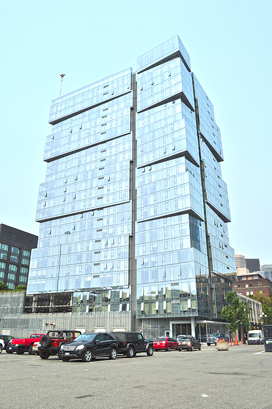
“The Wave” — the west tower of the Stadium Place complex — as seen from the parking lot of Lumen Field in August 2017
“The Wave” — the west tower of the Stadium Place complex — as seen from the parking lot of Lumen Field in August 2017. Stadium Place S is the street to the north of the parking lot, where the white van is parked behind the orange bollards. Photograph by Wikimedia Commons user Joe Mabel, licensed under Creative Commons Attribution 4.0 International.

E Shore Drive

This private road in the gated Broadmoor neighborhood goes just under 800 feet from Broadmoor Drive E in the west to just east of Waverly Way E in the east. The northernmost street in the development, it runs parallel to the Union Bay shoreline about 950 feet to the northwest, whence its name.

SW Wilton Court

As Phillip H. Hoffman, director of the Alki History Project, tells us in his article “What’s in a Name?,” this street was named after Benjamin Wilton Baker (1860–1934), husband of Julia Curry Williams (1861–1950) and father of Marguerite Baker (1890–?), after whom SW Marguerite Court is named. The Bakers were proprietors of Rose Lodge, a summer resort which once stood where the eastern portion of SW Wilton Court is now.

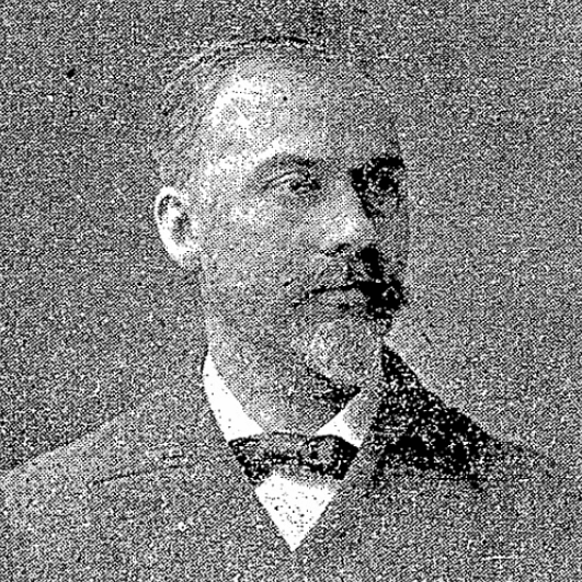
Benjamin Wilton Baker, 1901
Benjamin Wilton Baker, from the November 30, 1901, issue of The Seattle Times
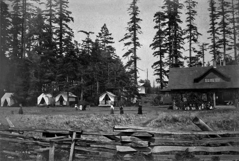
Rose Lodge circa 1913
Rose Lodge and tents from beach, 1913

SW Wilton Court begins at SW Hinds Street across the street from the Bar-S Playground, and goes just over 700 feet southeast to 63rd Avenue SW between Beach Drive SW and SW Marguerite Court. It is a private right-of-way between 64th Avenue SW and 63rd Avenue SW.

Montana Circle

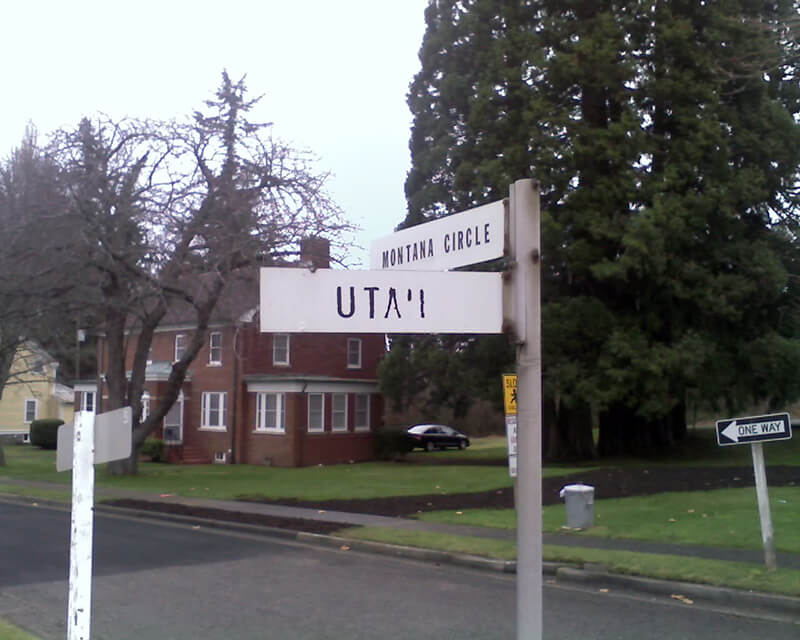
Like almost every other street in Fort Lawton (1900−2011), which became Discovery Park, Montana Circle was named after a state of the Union. Unlike almost every other street in Discovery Park, however, Montana Circle is a private road and in fact not part of the park at all. This is because the houses here, originally built for non-commissioned officers, were in use as military housing at the time the Army officially closed the fort. According to Monica Wooton of the Magnolia Historical Society, writing in the Queen Anne & Magnolia News, this meant that the property had to be sold at market rate instead of returned to the city as surplus, as most of the rest of the park had been. The city did manage to come up with $11 million to demolish some non-historic housing and restore the forest, but

Friends of Discovery Park could not get a partnership with government and other entities needed to purchase the Officer’s Row and NCO housing because of the cost mandated by the Privatization Act [while] the economic recession was taking hold.

As the Seattle Daily Journal of Commerce reported in April 2016,

The 13 homes in Montana Circle at Fort Lawton all have sold in about three months, and prices on the ones that have closed average $484 a square foot. Prices ranged from $799,000 to $1,050,000.

This provided a nice profit for the real estate firm that bought Officer‘s Row and Montana Circle from the military for $9.5 million.

Montana Circle begins at Discovery Park Boulevard just east of Kansas Avenue and loops around to rejoin Discovery Park Boulevard around 100 feet to the east.

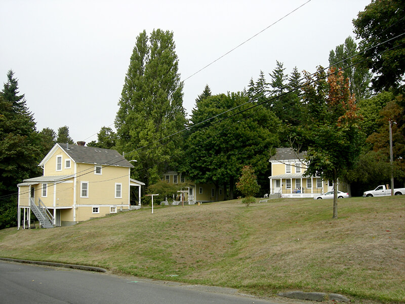
Street sign at corner of Montana Circle and Utah Street, January 15, 2011
Street sign at corner of Montana Circle and Utah Street (now Discovery Park Boulevard), January 15, 2011. Photograph by Benjamin Lukoff. Copyright © 2011 Benjamin Lukoff. All rights reserved.

NE Thornton Place

Thornton Creek runs 18 miles from Shoreline to Seattle, where it empties into Lake Washington at Matthews Beach Park. Its watershed, which drains 11.6 square miles, is the largest in Seattle. Yet until recently, no street bore its name — and the one that now does is a short private road.

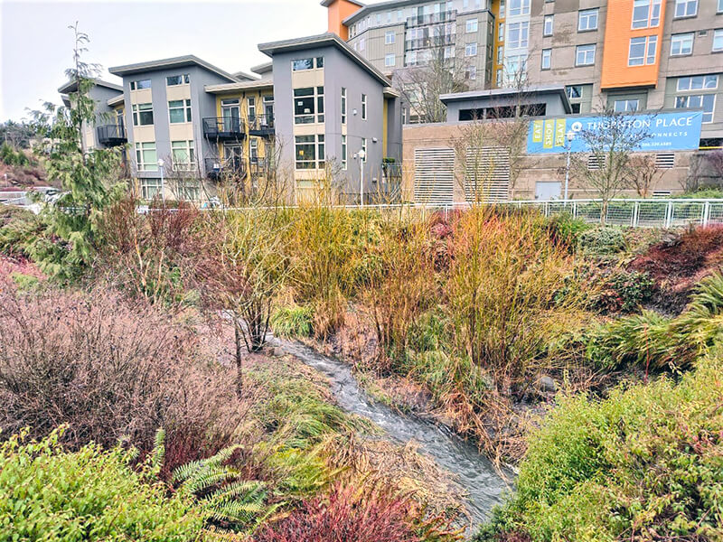
NE Thornton Place, which runs not quite 500 feet between 3rd Avenue NE and NE 103rd Street, cuts through the Thornton Place development, built on the site of a former Northgate Mall parking lot under which the South Fork of Thornton Creek ran in a culvert. A portion of the creek was daylighted as part of the project. (Incidentally, I had the pleasure of seeing the IMAX version of The Beatles: Get Back – The Rooftop Concert at the Regal Thornton Place on January 30 of this year, the 53rd anniversary of the historic event. I am an even bigger fan of the Beatles than I am of odonymy!) You can read more about the Thornton Creek Water Quality Channel at Wedgwood in Seattle History.

Thornton Creek Water Quality Channel with apartments and Thornton Place sign in background
Thornton Creek Water Quality Channel, with Thornton Place development in background. Photograph courtesy of Wedgwood in Seattle History. Copyright © 2023 Wedgwood in Seattle History. All rights reserved.

I originally wrote here that “The creek is named for John Q. Thornton (1825–1904), who… never actually lived in the Seattle area, but in 1885 bought land near what are today Meridian Park and Twin Ponds Park, at or near the headwaters of Meridian Creek, a tributary of the North Fork of Thornton Creek….” However, in the summer of 2022, the person whose article on Thornton I cited told me that they no longer believed this to be the case, and had edited their article accordingly. The creek’s namesake, therefore, remains a mystery.

Twin Maple Lane NE

This private cul-de-sac at the end of 24th Avenue NE south of NE 60th Street appears, according to an article in the June 19, 1927, edition of the Seattle Post-Intelligencer, to have been established that very year. According to James Bush writing for the Seattle Sun, Ravenna Park (or perhaps a portion thereof) was once known as Twin Maple Park, and

[William Wirt] Beck is officially remembered by two of the smallest civic gestures ever performed. In keeping with the early practice of giving names to small bits of park property, the concrete-covered triangle of land at the intersection of 15th Avenue Northeast and Cowen Place was dubbed Beck Place. And, his beloved Twin Maples Park is memorialized by Twin Maples Lane Northeast, a half-block street where 24th Avenue Northeast meets the park border.

Note that the typos are in the Sun article, not this post — the sign quite clearly says Maple, not Maples.

Riviera Place NE

This narrow street, created in 1926 as part of Riviera Beach, an Addition to King County, Washington, Divisions № 1, 2, 3, and 4, and situated between the shoreline of Lake Washington and the right-of-way of the Northern Pacific Railway, appears on the plats simply as “Road” — it first appears in The Seattle Times on July 20, 1930, as “Riviera Beach Road,” and then on July 2, 1932, with its current name. The name simply means ‘coastline’ in Italian.

Today, Riviera Place NE begins at the north city limits, where Seattle meets Lake Forest Park at the NE 145th Street right-of-way, and goes nearly a mile south along the Lake Washington shoreline to a spot a few houses north of NE 125th Street, where it ends at one house and picks up again on the other side of its neighbor. From there, it runs 1¼ miles south to its end at Lake Shore Boulevard NE between NE 100th Street and NE 103rd Street. The portions between the NE 135th Street right-of-way and NE 125th Street are private.

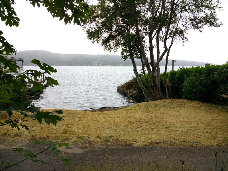
Riviera Place NE is probably most notable to the city at large for being the location of the NE 130th Street End park, which became an official park in 2019 after years of controversy. It’s not, strictly speaking, a shoreline street end, because it’s owned by Seattle Parks and Recreation, rather than being a right-of-way under the jurisdiction of the Seattle Department of Transportation. This is because it was never properly dedicated to the public in 1932 (see background and court filings). For years, it had been treated as just another shoreline street end, but in 2012, when the city announced its intention to make improvements to the beach to improve public access, the neighbors on either side filed suit, and ended up having their ownership of the lot confirmed. The city ended up having to exercise its right of eminent domain, condemned the property, and paid the neighbors $400,000 each. (As unfortunate as it was to have to pay $800,000 for the street end, I’d say it was worth it, as NE 130th is the only accessible shoreline street end north of NE 43rd Street, and the only public lake access, period, north of Matthews Beach [around where NE 95th Street would be if it had been platted into the water].)

View of NE 130th Street park on Lake Washington east of Burke-Gilman Trail and Riviera Place NE, June 18, 2019.
View of NE 130th Street End park on Lake Washington east of Riviera Place NE, June 18, 2019. Photograph by Flickr user Seattle Parks and Recreation, licensed under Creative Commons Attribution 2.0 Generic

Ridge Drive NE

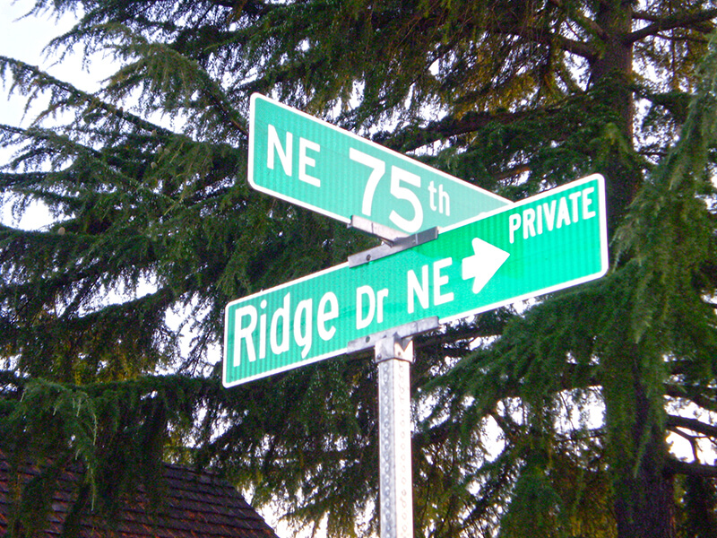
This private road, which lies entirely within the Sand Point Country Club, runs ⅖ of a mile from the main gate at NE 75th Street in the south to the intersection of Fairway Drive NE and Lakemont Drive NE in the north. It is so named for its central location atop the hill that gives the adjacent neighborhood, View Ridge, its name.

As local historian Valarie Bunn explains on her blog, the Sand Point Country Club, founded by Samuel E. Hayes, opened in 1927. As with two contemporaneous developments, Broadmoor and Windermere, its exclusivity was a selling point. An advertisement in the May 5, 1929, issue of The Seattle Times spelled this out more explicitly than usual: “Sand Point Country Club homesites are selling fast… because every homesite owner enjoys forever a close-in retreat from Seattle’s mobs of tomorrow… because every homesite owner is protected in his investment by carefully drawn restrictions against the admixture of objectionable buildings or races.” The racial restrictive covenant covering the neighborhood reads:

No tract shall be sold, conveyed, rented or leased in whole or in part to any Hebrew or to any person of the Malay, Ethiopian or any other Negro or any Asiatic race, or any descendant of any thereof. No tract shall be used or occupied in whole or in part by any Hebrew or by any person of the Malay, Ethiopian or any other Negro or any Asiatic race, or any descendant of any thereof, except only employees in the domestic service on the premises of persons qualified as herein provided as occupants.

Sign at corner of NE 75th Street and Ridge Drive NE, August 25, 2009
Signs at corner of NE 75th Street and Ridge Drive NE, August 25, 2009. Photograph by Benjamin Lukoff. Copyright © 2009 Benjamin Lukoff. All rights reserved.

Broadmoor Drive E

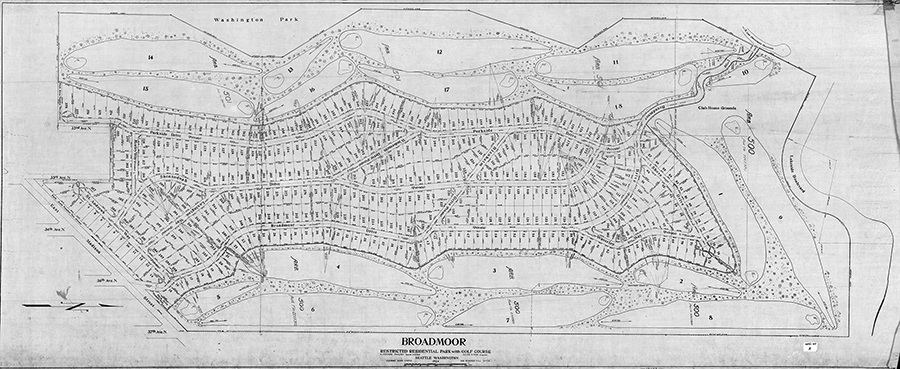
This street runs just shy of a mile through the gated Broadmoor neighborhood and golf course from its south entrance at E Madison Street at 36th Avenue E to its north entrance at E Foster Island Road.

An article in the May 18, 1924, issue of The Seattle Times noted that “[Broadmoor’s] roadways will not be public streets as in other residential sections of the city,” calling this “one of the unmatched features of this community,” and adds that “certain restrictions have been named both as to the class of residences that may be constructed as well as to those who will be admitted to membership.” The entire community being private was a first for Seattle, and in fact has never been repeated — the Sand Point Country Club was also established in the late 1920s, but was in unincorporated King County at the time and wasn’t annexed until 1953, whereas Windermere, established within Seattle city limits around the same time, was in fact platted as a traditional neighborhood, albeit one with private amenities.

Speaking of those “certain restrictions,” by the way, it seems that even in the 1920s one could not say openly in the press what one really meant. But Broadmoor deeds and their racial restrictive covenants are public record:

No part of said property hereby conveyed shall ever be used or occupied by any Hebrew or by any person of the Ethiopian, Malay or any Asiatic Race, and the party of the second part, his heirs, personal representatives or assigns, shall never place any such person in the possession or occupancy of said property or any part thereof, nor permit the said property, or any part thereof, ever to be used or occupied by any such person, excepting only employees in the domestic service on the premises of persons qualified hereunder as occupants and users and residing on the premises.

Broadmoor: Restricted Residential Park With Golf Course, 1924.
Broadmoor: Restricted Residential Park With Golf Course, 1924. Courtesy of the Seattle Municipal Archives, Identifier 1423.

The origin of the Broadmoor name is not entirely clear. Did it have anything to do with the Broadmoor Golf Club in Colorado Springs, which opened in 1918? Or with the moors of Scotland, home of modern golf? The above-mentioned Seattle Times article, which is so similar to one in the Seattle Post-Intelligencer it must have been based on a Puget Mill Company press release, doesn’t say. (My friend, local historian Joe Mabel, notes the best-known Broadmoor in the U.K. is actually a high-security psychiatric hospital founded in 1863.) It may just be that “Broadmoor” was considered to be “elegant.” Perhaps the answer lies somewhere in the personal papers of Edwin Gardner Ames, Puget Mill president and one of the developers of Broadmoor along with Grosvenor Folsom and George W. Johnson.

W Briarcliff Lane

W Briarcliff Lane runs about 400 feet west from 39th Avenue W before it makes a 90° turn to the north and becomes Briarcliff Lane W. That segment runs about 200 feet north to W Dravus Street. A private road, it is part of the Briarcliff development on what was once Briarcliff School (1949–1984, demolished 2003). You can read more about the history of Briarcliff at HistoryLink.com and on the website of the Magnolia Historical Society.

As for the school’s name? In an article published August 21, 1948, The Seattle Times noted that “on recommendation of district residents, the board named the new school being built in the Magnolia area the Briarcliff School.”

Expedia Group Way W

“Look! They’ve finally signed the W Galer Street Flyover!” I thought to myself the other day as I drove onto the Magnolia Bridge onramp from 15th Avenue W. “I wonder why they took so long?” (It was built in 2002.)

Then I saw the sign that directed drivers to take the flyover if they were headed toward Expedia Group Way W. Of course… it was because Expedia was moving their corporate headquarters from Bellevue to Interbay, and the first employees were scheduled to arrive this month.

It made sense for the private road — originally Amgen Court W after the campus’s previous corporate occupants — to change its name… but why to Expedia Group?

Yes, Expedia’s official name is Expedia Group — it’s the parent company not only of the eponymous online travel agency but of many other brands, including Hotels.com, Orbitz, Travelocity, Hotwire, and CheapTickets — but still. Wouldn’t Expedia Way W sound and look better? Adding the “group” makes the name sound much more corporate to my ear.