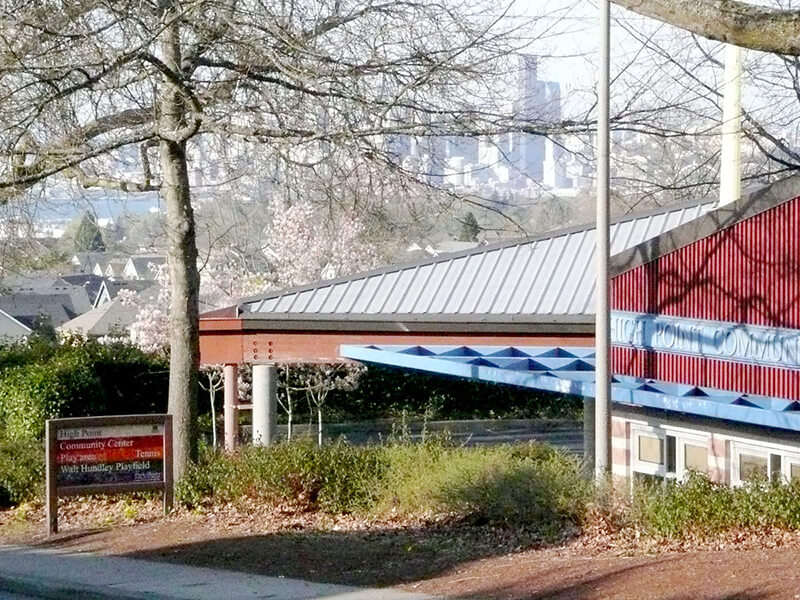
This street was named after High Point, originally developed by the Seattle Housing Authority in 1942 as defense housing and redeveloped in 2004 (see SW Bataan Street and Lanham Place SW for more history). I appear not to have mentioned in either of those posts why the development was so named — as one might guess, the city’s highest point (520 feet) is there, at the corner of 35th Avenue SW and SW Myrtle Street.
High Point Drive SW begins at 30th Avenue SW and SW Juneau Street and goes nearly ⅔ of a mile south to Sylvan Way SW and SW Holly Street.
Born and raised in Seattle, Benjamin Donguk Lukoff had his interest in local history kindled at the age of six, when his father bought him settler granddaughter Sophie Frye Bass’s Pig-Tail Days in Old Seattle at the gift shop of the Museum of History and Industry. He studied English, Russian, and linguistics at the University of Washington, and went on to earn his master’s in English linguistics from University College London. His book of rephotography, Seattle Then and Now, was published in 2010. An updated version came out in 2015.
This street was named for Lincoln Park, which occupies Williams Point in West Seattle. Originally called Williams Point Park in the Olmsted Brothers’ 1908 report to the city, the 135-acre park was intended to be named Fauntleroy Park. However, when it opened in 1922, it was decided to name it after President Abraham Lincoln (1809–1865) instead, according to Seattle parks historian Don Sherwood. This required that Lincoln Beach, just to the north, be renamed Lowman Beach, and that Lincoln Park Playfield on Capitol Hill (named for the adjacent Lincoln Reservoir) be renamed Broadway Playfield. (Today, the entire tract is known as Cal Anderson Park, which contains the reservoir and the once-again-renamed Bobby Morris Playfield. A Fauntleroy Park was finally established in the early 1970s.)
Lincoln Park Way SW begins at Beach Drive SW and 48th Avenue SW and goes ¼ of a mile southeast to 47th Avenue SW between SW Myrtle Street and SW Othello Street. The park begins 500 feet to the south, at the corner of 47th Avenue SW and SW Fontanelle Street.
Born and raised in Seattle, Benjamin Donguk Lukoff had his interest in local history kindled at the age of six, when his father bought him settler granddaughter Sophie Frye Bass’s Pig-Tail Days in Old Seattle at the gift shop of the Museum of History and Industry. He studied English, Russian, and linguistics at the University of Washington, and went on to earn his master’s in English linguistics from University College London. His book of rephotography, Seattle Then and Now, was published in 2010. An updated version came out in 2015.
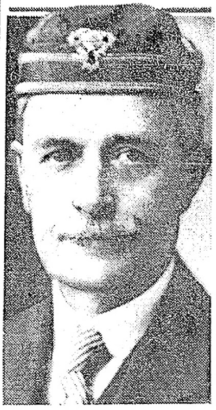
This West Seattle street was created in 1919 as part of the plat of Kirkwood, an Addition to the City of Seattle, filed by Isabell A. Kirkwood (1833–1926), who named the nearby Rutan Place SW after her maiden name. The plat document was notarized by lawyer Frank Pardee Lewis (1851–1938), and since I can find no connection to any other Lewis, I assume Kirkwood named it after him. According to Capitol Hill Seattle, Lewis, who lived at the corner of 18th Avenue E and E Denny Way,
…was from Triangle, New York, and moved to Seattle in 1887. He was a prominent attorney with offices in the Lowman Building downtown starting in 1890. He went to the office almost every day until his death in 1938. Mr. Lewis was elected to the Washington State Legislature in 1895; he was also a member of the Scottish Rite Masons.
Lewis Place SW begins at SW Hudson Street between Erskine Way SW and California Avenue SW and goes just over 550 feet northwest, then north, to Erskine Way SW just west of California.
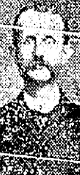
Frank Pardee Lewis, from his Seattle Times obituary, April 12, 1938
Born and raised in Seattle, Benjamin Donguk Lukoff had his interest in local history kindled at the age of six, when his father bought him settler granddaughter Sophie Frye Bass’s Pig-Tail Days in Old Seattle at the gift shop of the Museum of History and Industry. He studied English, Russian, and linguistics at the University of Washington, and went on to earn his master’s in English linguistics from University College London. His book of rephotography, Seattle Then and Now, was published in 2010. An updated version came out in 2015.
Rutan Place SW goes around 350 feet south from SW Edmunds Street between 44th Avenue SW and 45th Avenue SW to a dead end just short of 45th, though the undeveloped right-of-way does continue to that street.
Born and raised in Seattle, Benjamin Donguk Lukoff had his interest in local history kindled at the age of six, when his father bought him settler granddaughter Sophie Frye Bass’s Pig-Tail Days in Old Seattle at the gift shop of the Museum of History and Industry. He studied English, Russian, and linguistics at the University of Washington, and went on to earn his master’s in English linguistics from University College London. His book of rephotography, Seattle Then and Now, was published in 2010. An updated version came out in 2015.
This street, which was created as part of the unrecorded plat of R.B. Wark’s 2nd Addition, is named for the Chinook Jargon word tillikum, meaning ‘people’.
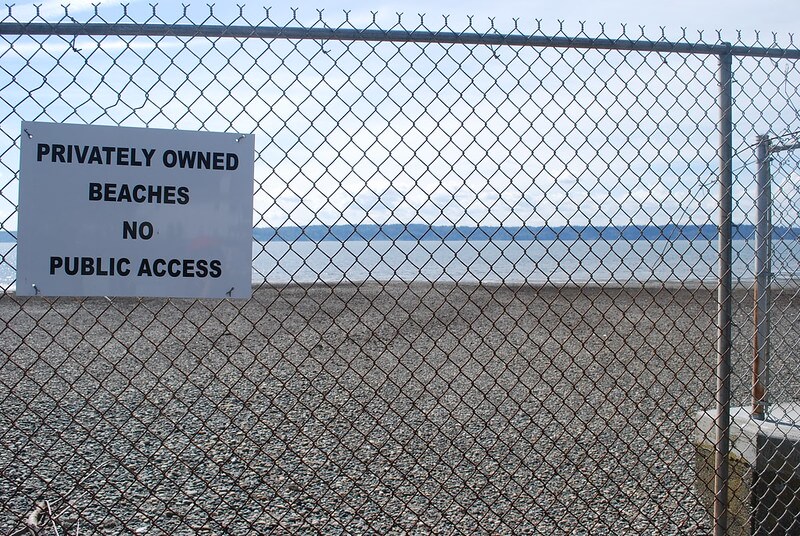
Tillicum Road SW begins at 46th Avenue SW just south of SW Thistle Street and goes ¼ mile southeast to SW Donovan Street, with a short interruption between house numbers 8470 and 8471 on the northwest and 8487 and 8488 on the southeast where the public right-of-way seems to be blocked by a private fence, effectively converting the road on either side into private driveways.
Born and raised in Seattle, Benjamin Donguk Lukoff had his interest in local history kindled at the age of six, when his father bought him settler granddaughter Sophie Frye Bass’s Pig-Tail Days in Old Seattle at the gift shop of the Museum of History and Industry. He studied English, Russian, and linguistics at the University of Washington, and went on to earn his master’s in English linguistics from University College London. His book of rephotography, Seattle Then and Now, was published in 2010. An updated version came out in 2015.
This West Seattle street was created in 1907 as part of the plat of Adams 1st Addition to Fauntleroy Park, filed by John F. Adams (1860–1954) and his wife, Maggie W. True Adams (1864–1941). The document was notarized by Bert Avery Northrop (1880–1963), who was the husband of the Adamses’ daughter Abbie T. Adams (1888–1984). In his Seattle Times obituary, we learn that John Adams was “one of Fauntleroy’s first residents, [who]… came here in 1897. He first was in the grocery business and entered the real-estate business in 1903.… Mr. Adams was known as the ‘mayor of Fauntleroy.’” Meanwhile, Northrop’s Times obituary reports he came to Seattle in 1902 and began practicing law in 1906; he married Abbie Adams in 1909.
Bert A. Northrop
Northrop Place SW begins at SW Thistle Street and goes a block north to SW Southern Street.
Born and raised in Seattle, Benjamin Donguk Lukoff had his interest in local history kindled at the age of six, when his father bought him settler granddaughter Sophie Frye Bass’s Pig-Tail Days in Old Seattle at the gift shop of the Museum of History and Industry. He studied English, Russian, and linguistics at the University of Washington, and went on to earn his master’s in English linguistics from University College London. His book of rephotography, Seattle Then and Now, was published in 2010. An updated version came out in 2015.
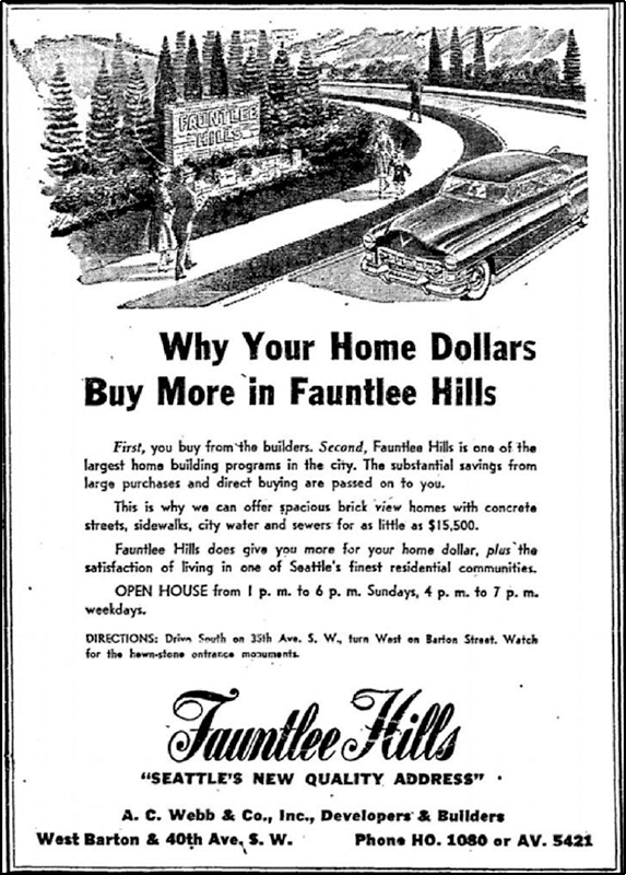
This street was created in 1955 as 43rd Avenue SW in the plat of Fauntlee Hills Division № 5. It received its current name in 1959. “Faunt” is an obvious reference to the greater Fauntleroy neighborhood, and Fauntlee Hills was developed on the western slope of the hill that rose up from Fauntleroy Cove, but I’m not sure where “lee” comes from. (I was thinking, perhaps, from “leeward,” but prevailing winds in Seattle are from the southwest, meaning this is the windward, not leeward, side of the hill. Perhaps Arthur C. Webb, the developer, simply thought it sounded euphonious.)
Like its neighbor Vashon View SW (which was originally named Fauntlee Place SW!), this appears to be the only crest in the city. (The USPS abbreviates these as CRST, while its Seattle street sign abbreviation is Cr.)
Fauntlee Crest SW begins at SW Concord Street and California Avenue SW and goes ¼ mile north to a dead end.
Advertisement for Fauntlee Hills in the November 1, 1953, issue of The Seattle Times
Born and raised in Seattle, Benjamin Donguk Lukoff had his interest in local history kindled at the age of six, when his father bought him settler granddaughter Sophie Frye Bass’s Pig-Tail Days in Old Seattle at the gift shop of the Museum of History and Industry. He studied English, Russian, and linguistics at the University of Washington, and went on to earn his master’s in English linguistics from University College London. His book of rephotography, Seattle Then and Now, was published in 2010. An updated version came out in 2015.
According to Seattle parks historian Don Sherwood’s sheet on Seola Park, this street began as a logging railroad. It was then replaced by the Charles Arey county road (“recently surveyed,” according to an article in the August 26, 1893, Seattle Post-Intelligencer), which was renamed Qualheim Road in 1914 by Carl Olsen Qualheim. It received its current name in 1956 when that portion of Arbor Heights was annexed to Seattle. “Seola” itself was the product of a naming contest:
In 1893, a family named Kakeldy built the first home on the beach.… Before long, children in the vicinity school referred to residents of Kakeldy Beach as the “Cackilty Chickens.”… In 1910 the beach residents sponsored a renaming contest which was won by Mel Miller, friend of the school’s teacher of Spanish, Agnes Quigley; his suggestion: “Se-ola = to know the wave.”
Seola Beach Drive SW begins at SW 106th Street between 28th Avenue SW and 31st Avenue SW and goes ⅞ of a mile south, then southwest, to a dead end at the beach, just past SW Seola Lane.
For its entire length, Seola Beach Drive SW forms the southern city limits of Seattle, separating it from Burien and unincorporated King County (White Center). (Unlike the northern city limits, formed by 145th Street, Seattle’s southern city limits are jagged. If they went due east from Seola Beach, Seattle would encompass large portions of Burien, Tukwila, and Renton; whereas if they followed a parallel set at the city limits’ northernmost point, everything south of Kenyon Street [approximately the north end of the South Park Bridge] would be lost by Seattle.)
Born and raised in Seattle, Benjamin Donguk Lukoff had his interest in local history kindled at the age of six, when his father bought him settler granddaughter Sophie Frye Bass’s Pig-Tail Days in Old Seattle at the gift shop of the Museum of History and Industry. He studied English, Russian, and linguistics at the University of Washington, and went on to earn his master’s in English linguistics from University College London. His book of rephotography, Seattle Then and Now, was published in 2010. An updated version came out in 2015.
This street was created as part of the 1889 plat of West Seattle Park and named after West Seattle developer and Seattle city councilman Uriah Roush Niesz (1849–1929). According to Images of America: West Seattle,
…In what is now the Admiral District, the now familiar moniker “West Seattle” was first used by Uriah Niesz when developing five-acre homesites in 1885.
[He took] a prominent part in the replatting and upbuilding of the city. He with other members of the council had mapped out the whole plan some time previous to the fire, which made it possible to accomplish their purpose.… As a member of the council Mr. Niesz was made chairman of the judiciary, finance and harbor and wharves committees and the last named took up the whole burden of replatting the business and shipping section of the city.… Herculean as was the task of this committee in bringing order out of chaos in this part of the city; in opening the way for land and water traffic to meet at a minimum cost of transshipment; in providing facilities for a marvelous growth in the business of a future great city; in short in giving the city a new birth, yet this great task paled into insignificance compared with the responsibilities resting upon the finance committee, of which Mr. Niesz was also chairman.
I find that contemporary biographies of pioneers tend to read like hagiographies, but in this case I think Niesz’s entire biography is worth a read.
At left, Niesz as part of a portrait of Seattle’s mayor and city councilmen for 1888–1890. At right, the photograph accompanying his obituary in the Seattle Post-Intelligencer issue of September 22, 1929.
SW Niesz Court begins at 50th Avenue SW just south of the College Street Ravine and goes two blocks east to 48th Avenue SW.
Born and raised in Seattle, Benjamin Donguk Lukoff had his interest in local history kindled at the age of six, when his father bought him settler granddaughter Sophie Frye Bass’s Pig-Tail Days in Old Seattle at the gift shop of the Museum of History and Industry. He studied English, Russian, and linguistics at the University of Washington, and went on to earn his master’s in English linguistics from University College London. His book of rephotography, Seattle Then and Now, was published in 2010. An updated version came out in 2015.
In History of Seattle from the Earliest Settlement to the Present Time, Clarence Bagley writes that Benton, who was born in Iowa and came to Seattle in 1890 from Montana,
…spent many years with different railroad companies. For a time he was connected with the Great Northern and later he became general passenger and freight agent for the Chicago, Burlington & Quincy Railroad at Seattle. The last few years of his life were spent in connection with the safe and lock trade. He was associated with the Norris Safe & Lock Company… Later Mr. Norris took over the safe and lock company and Mr. Benton the desk department of the business, after which he was joined by Edward Herald in a partnership that was continued under the name of the Benton-Herald Desk & Safe Company until [his death].
Born and raised in Seattle, Benjamin Donguk Lukoff had his interest in local history kindled at the age of six, when his father bought him settler granddaughter Sophie Frye Bass’s Pig-Tail Days in Old Seattle at the gift shop of the Museum of History and Industry. He studied English, Russian, and linguistics at the University of Washington, and went on to earn his master’s in English linguistics from University College London. His book of rephotography, Seattle Then and Now, was published in 2010. An updated version came out in 2015.
SW Teig Place begins at 57th Avenue SW just north of SW Stevens Street and goes around 450 feet northeast to 56th Avenue SW just north of SW Lander Place.
Born and raised in Seattle, Benjamin Donguk Lukoff had his interest in local history kindled at the age of six, when his father bought him settler granddaughter Sophie Frye Bass’s Pig-Tail Days in Old Seattle at the gift shop of the Museum of History and Industry. He studied English, Russian, and linguistics at the University of Washington, and went on to earn his master’s in English linguistics from University College London. His book of rephotography, Seattle Then and Now, was published in 2010. An updated version came out in 2015.
As Phillip H. Hoffman, director of the Alki History Project, tells us in his article “What’s in a Name?,” this street was named after Benjamin Wilton Baker (1860–1934), husband of Julia Curry Williams (1861–1950) and father of Marguerite Baker (1890–?), after whom SW Marguerite Court is named. The Bakers were proprietors of Rose Lodge, a summer resort which once stood where the eastern portion of SW Wilton Court is now.
Benjamin Wilton Baker, from the November 30, 1901, issue of The Seattle Times
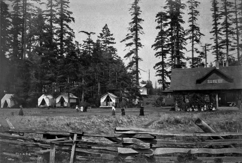
Rose Lodge and tents from beach, 1913
SW Wilton Court begins at SW Hinds Street across the street from the Bar-S Playground, and goes just over 700 feet southeast to 63rd Avenue SW between Beach Drive SW and SW Marguerite Court. It is a private right-of-way between 64th Avenue SW and 63rd Avenue SW.
Born and raised in Seattle, Benjamin Donguk Lukoff had his interest in local history kindled at the age of six, when his father bought him settler granddaughter Sophie Frye Bass’s Pig-Tail Days in Old Seattle at the gift shop of the Museum of History and Industry. He studied English, Russian, and linguistics at the University of Washington, and went on to earn his master’s in English linguistics from University College London. His book of rephotography, Seattle Then and Now, was published in 2010. An updated version came out in 2015.
This street, which is part of the unrecorded plat of B.W. Baker’s Rose Lodge Addition, was named after Marguerite Baker (1890–?), eldest daughter of Benjamin Wilton Baker (1860–1934) and Julia Curry Williams (1861–1950). The Bakers were proprietors of Rose Lodge, a summer resort which once stood where the subdivision is now.
The public right-of-way is a footpath that runs just over 300 feet from 63rd Avenue SW in the southeast to 64th Avenue SW in the northwest. Vehicular access to the homes is from a public alley to the north and a private one to the south.
Born and raised in Seattle, Benjamin Donguk Lukoff had his interest in local history kindled at the age of six, when his father bought him settler granddaughter Sophie Frye Bass’s Pig-Tail Days in Old Seattle at the gift shop of the Museum of History and Industry. He studied English, Russian, and linguistics at the University of Washington, and went on to earn his master’s in English linguistics from University College London. His book of rephotography, Seattle Then and Now, was published in 2010. An updated version came out in 2015.
W.T. Campbell was a long-time West Seattle resident living on the hillside above Alki. He was an early advocate for Alki annexation to the City of West Seattle, a real estate developer, early West Seattle school principal, banker, and a member of the Seattle City Council beginning 1924. He would serve as a city councilmember until 1929.
W.T. Campbell, from the October 11, 1933, issue of The Seattle Times
SW Campbell Place begins at SW Lander Street a block west of SW Admiral Way and goes just over 550 feet southwest to 56th Avenue SW at the north edge of Schmitz Park.
Born and raised in Seattle, Benjamin Donguk Lukoff had his interest in local history kindled at the age of six, when his father bought him settler granddaughter Sophie Frye Bass’s Pig-Tail Days in Old Seattle at the gift shop of the Museum of History and Industry. He studied English, Russian, and linguistics at the University of Washington, and went on to earn his master’s in English linguistics from University College London. His book of rephotography, Seattle Then and Now, was published in 2010. An updated version came out in 2015.
I first came across the Alki History Project while doing research for my article on SW Bronson Way. I’m not sure how I missed it before. The paper that mentioned Ira Bronson was “If at First You Don’t Succeed…,” a fascinating history of municipal governance and elections in West Seattle, and when I looked at their list of other papers I was thrilled to see among them “What’s in a Name?” — an investigation of Alki street names, both current and those changed long ago. Frater Avenue SW is the first of a number of posts in which I will be citing this paper, written by Phillip H. Hoffman, director of the project.
Frater Avenue SW originates in the 1955 plat of Anderson’s Soundview Terrace Addition № 2. Why Anderson, Caple, or Knowlton weren’t chosen instead for the honor (this being the only new street in the small subdivision, and those being the surnames of the three couples who filed the plat) isn’t clear. But, as Hoffman notes, SW Frater Street and SW Frater Place (both of which have since been vacated) were just to the west in the adjacent plat. In addition, an earlier Frater Avenue SW had existed, until it was vacated in 1942, just southeast of where today’s Frater Avenue begins at SW Spokane Street. The current Frater Avenue must have been named after one of these three streets.
But, of course, that leaves the question of who those three streets initially honored, and according to Hoffman,
Frater Avenue first appears in the plat Partition of Crawford Tract as ordered in King County Superior Court, Cause № 64110, June 17, 1915. [A.W.] Frater was the presiding judge.… The court commissioners assisting in the adjudication of a land title and ownership dispute before Judge Frater that resulted in the Crawford Tract plat probably named Frater Avenue in 1915, along with all the other streets appearing in the plat.
Archibald Wanless Frater (1856–1925), according to Cornelius Holgate in Seattle and Environs, was born in Ohio and came to Washington in 1888. Initially settling in Tacoma, he moved to Snohomish the next year and came to Seattle in 1898.
Judge Archibald Wanless Frater, from the front cover of The Seattle Mail & Herald, June 3, 1905
Today’s Frater Avenue SW begins at 57th Avenue SW just north of SW Hinds Street and goes ⅛ of a mile southeast to SW Spokane Street just west of 56th Avenue SW.
Born and raised in Seattle, Benjamin Donguk Lukoff had his interest in local history kindled at the age of six, when his father bought him settler granddaughter Sophie Frye Bass’s Pig-Tail Days in Old Seattle at the gift shop of the Museum of History and Industry. He studied English, Russian, and linguistics at the University of Washington, and went on to earn his master’s in English linguistics from University College London. His book of rephotography, Seattle Then and Now, was published in 2010. An updated version came out in 2015.
This West Seattle street was created in 1900 as part of the Replat of the West Seattle Land & Improvement Co’s. Third Plat. Originally Beach Way, it was renamed Bronson Way in 1907, when Seattle annexed West Seattle. Given that Ira Hull Bronson (1868–1930) was attorney for and vice president of the WSL&IC, it seems a fair assumption that it was named for him.
Ira Bronson, from his June 17, 1930, obituary in The Seattle Times. He had died the day before.
Bronson, a former president of the American Bar Association, was described in the June 18, 1930, issue of The Seattle Times as a “pioneer Seattle attorney and leader in admiralty circles… [who] was one of the founders of the Inland Navigation Company, which later became the Puget Sound Navigation Company.” (The PSNC’s domestic ferry routes were bought by the state in 1951, forming Washington State Ferries, and most of its Canadian routes became part of the new BC Ferries system in 1961. The firm, now known as the Black Ball Ferry Line, now runs one boat, the MV Coho, between Port Angeles and Victoria. Through a series of mergers, Bronson’s law firm is now Stoel Rives.)
Though the right-of-way begins further inland, SW Bronson Way only physically exists between Harbor Avenue SW and Elliott Bay. About 180 feet long, it is nearly 90 feet wide (quite a length-to-width ratio!) and essentially serves as a public parking lot. It is a shoreline street end, platted into the water, and features an unobstructed view of the city across the bay.
Born and raised in Seattle, Benjamin Donguk Lukoff had his interest in local history kindled at the age of six, when his father bought him settler granddaughter Sophie Frye Bass’s Pig-Tail Days in Old Seattle at the gift shop of the Museum of History and Industry. He studied English, Russian, and linguistics at the University of Washington, and went on to earn his master’s in English linguistics from University College London. His book of rephotography, Seattle Then and Now, was published in 2010. An updated version came out in 2015.
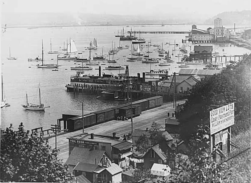
This street, created in 1888 as part of the First Plat of West Seattle by the West Seattle Land and Improvement Company, was originally named Grand Avenue. It was renamed, along with many other West Seattle streets, in 1907, when West Seattle was annexed by Seattle. The name was a reference to the WSL&IC ferry terminal at what is today Harbor Avenue SW at California Way SW. The West Seattle Water Taxi has been operating from the same location since 1997.
Today, Ferry Avenue SW begins at California Way SW and goes about ³⁄₇ of a mile southwest to just past California Avenue SW, at California Place park (built on the site of a former streetcar terminal; before that, a cable car ran up the Ferry Avenue right-of-way from Elliott Bay to this location). It resumes on the other side of the park at SW Hill Street and goes a further 600 feet southwest to SW Walker Street.
Born and raised in Seattle, Benjamin Donguk Lukoff had his interest in local history kindled at the age of six, when his father bought him settler granddaughter Sophie Frye Bass’s Pig-Tail Days in Old Seattle at the gift shop of the Museum of History and Industry. He studied English, Russian, and linguistics at the University of Washington, and went on to earn his master’s in English linguistics from University College London. His book of rephotography, Seattle Then and Now, was published in 2010. An updated version came out in 2015.
This street, created in 1919 by Ordinance 39638, is named for W Marginal Way SW. It begins there and goes just under 800 feet northwest to a dead end underneath the West Seattle Bridge. The Duwamish Trail continues on from there to the West Seattle Bridge Trail, while the 18th Avenue SW stairway heads south up the hill to SW Charlestown Street in Pigeon Point.
Born and raised in Seattle, Benjamin Donguk Lukoff had his interest in local history kindled at the age of six, when his father bought him settler granddaughter Sophie Frye Bass’s Pig-Tail Days in Old Seattle at the gift shop of the Museum of History and Industry. He studied English, Russian, and linguistics at the University of Washington, and went on to earn his master’s in English linguistics from University College London. His book of rephotography, Seattle Then and Now, was published in 2010. An updated version came out in 2015.
This street was created in 1905 as part of the Steel Works Addition to West Seattle by Albert C. Phillips. Originally Cityview Street, it formed a trio with Grandview Street and Bayview Street, which are today SW Hinds Street and SW Spokane Street, and was named for its view of Seattle, to the northwest across Elliott Bay.
SW City View Street begins at 35th Avenue SW as a driveway and foot path which becomes a paved street just before 34th Avenue SW and extends just beyond, about 325 feet in all. The right-of-way continues through a greenbelt, and the road picks up at again at SW Admiral Way, where it goes 500 feet east to end at 30th Avenue SW.
Born and raised in Seattle, Benjamin Donguk Lukoff had his interest in local history kindled at the age of six, when his father bought him settler granddaughter Sophie Frye Bass’s Pig-Tail Days in Old Seattle at the gift shop of the Museum of History and Industry. He studied English, Russian, and linguistics at the University of Washington, and went on to earn his master’s in English linguistics from University College London. His book of rephotography, Seattle Then and Now, was published in 2010. An updated version came out in 2015.
(The tideland streets in West Seattle were, with a few exceptions, named after states: Illinois, [New] Hampshire, Arkansas, [New] Jersey, Rhode Island, [New] Mexico, Maryland, Louisiana, Georgia, [North and South] Carolina, Florida, Mississippi, Oregon, [North and South] Dakota, and Idaho. Of the ones confined to West Seattle, only Maryland remains [Florida, Oregon, Dakota, and Idaho also, or only, appear east of the West Duwamish Waterway].)
Today, SW Maryland Place begins at Elm Place SW and goes around 130 feet northeast to Harbor Avenue SW.
Born and raised in Seattle, Benjamin Donguk Lukoff had his interest in local history kindled at the age of six, when his father bought him settler granddaughter Sophie Frye Bass’s Pig-Tail Days in Old Seattle at the gift shop of the Museum of History and Industry. He studied English, Russian, and linguistics at the University of Washington, and went on to earn his master’s in English linguistics from University College London. His book of rephotography, Seattle Then and Now, was published in 2010. An updated version came out in 2015.


.jpg)