Aurora Avenue N

What is now Aurora Avenue N began in 1888 as Aurora Street in Denny & Hoyt’s Addition to the City of Seattle, Washington Territory, previously discussed in our post on Dravus Street. Edward Blewett and his wife, Carrie, of Fremont, Nebraska, were the landowners, and Edward Corliss Kilbourne (1856–1959) filed the plat as attorney-in-fact for the Blewetts. Dr. Kilbourne (a dentist), was from Aurora, Illinois, and it seems to be generally accepted (The Fremocentrist, Wedgwood in Seattle History, Fremont Neighborhood Council, Pig-Tail Days in Old Seattle) that he named the street after his hometown.

(I have seen elsewhere [HistoryLinkWashington’s Pacific Highway], that Aurora was given its name sometime in the early 20th century by George F. Cotterill, mayor of Seattle from 1912–1914, because it was “the highway to the north, toward the aurora borealis,” but they have the century wrong, and Aurora Street was no highway in 1888. In addition, those two pages call him “city engineer, later mayor,” but he was never city engineer — although he was assistant city engineer from 1892–1900. The Licton Springs Community Council mentions both theories.)

At any rate, Ordinance 6947, filed on June 6, 1901, refers to the street as Aurora Street, and Ordinance 7942, filed on November 5 of that year, refers to it as Aurora Avenue. I can find no specific record of the name change, but Ordinance 6864, filed on May 8, has to do with “altering, defining and establishing the names of streets in the City of Seattle in the portion thereof lying north of Lake Union, Salmon Bay and the route of the Lake Washington Canal,” and is likely responsible. (No text is available online for the ordinance, and the drafters of Ordinance 6947 must have neglected to take the change into account.)

Aurora Avenue N might have remained just another North Seattle street were it not for the decision to route the Pacific Highway, U.S. Route 99, across the Lake Washington Ship Canal there instead of Stone Way N, Albion Place N, Whitman Avenue N, or Linden Avenue N. As it happened, Aurora was chosen as the location for the crossing (known today as the Aurora Bridge), and the name was officially extended through Queen Anne to Downtown Seattle in 1930 in preparation for the bridge’s opening in 1932.

Added July 14, 2023: I spoke to Feliks Banel of KIRO Newsradio for one of his All Over the Map segments, this one on how the Aurora Bridge got its name. I didn’t appear on air, but was mentioned in both the audio and web versions of the story.

Lake Union, Lake Washington Ship Canal, the Fremont Bridge, and the George Washington Memorial Bridge (Aurora Bridge), Seattle, Washington, circa 1932, from https://flickr.com/photos/uw_digital_images/4860576629/
Postcard of Lake Union, Lake Washington Ship Canal, the Fremont Bridge, and the George Washington Memorial Bridge (Aurora Bridge), circa 1932. View looks southeast, with Fremont in foreground. Public domain image from University of Washington Libraries Digital Collections.
Aurora Bridge, 2011, from https://flickr.com/photos/mlinksva/5996553637/, public domain
Aurora Bridge, 2011. View looks east, with Gas Works Park and Wallingford neighborhood at center, Lake Union and Capitol Hill at right. Public domain photo by Flickr user Mike Linksvayer.

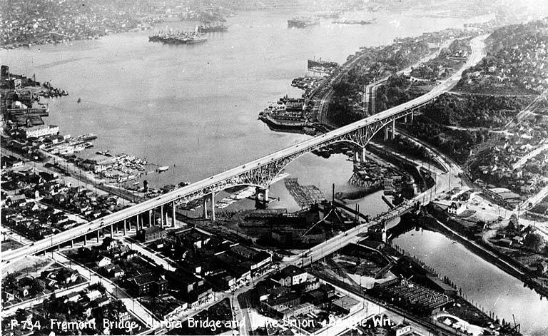
Today, Aurora Avenue N begins at 7th Avenue N and Harrison Street by the north portal of the State Route 99 Tunnel and goes 7⅘ miles north to the city limits; the name continues 3 further miles to the King–Snohomish county line, and the highway another 12 miles beyond that to Broadway in Everett. A block-long segment from 6th Avenue and Battery Street to Denny Way has been renamed Borealis Avenue, and Aurora between Denny Way and Harrison Street is once again 7th Avenue N. A two-block-long segment underneath the north approach to the Aurora Bridge has also been changed to Troll Avenue N.

Union Bay Place NE

This street, which runs ⅕ of a mile from 30th Avenue NE in the northwest to the “five corners” intersection with NE 45th Street, NE 45th Place, and Mary Gates Memorial Drive NE, was created in 1907 as part of the Exposition Heights addition. Four years later, the street was extended southeast of NE 45th Street through University of Washington property to NE 41st Street. However, in 1995 that portion was renamed Mary Gates Memorial Drive NE.

As can be seen in the map below, it did once parallel Union Bay; however, when the Montlake Cut of the Lake Washington Ship Canal opened in 1916, the lake and bay dropped by 8.8 feet to match the level of Lake Union and this was no longer waterfront property. The southwest corner of this map is now entirely devoted to commercial and residential use.

Portion of plat map of Exposition Heights showing Union Bay and Union Bay Place

Union Bay itself was named in 1854 by settler Thomas Mercer, with the idea that it and Lake Union, which he also named, would one day be part of a connection from Lake Washington to Puget Sound. As mentioned above, this did end up happening 62 years later.

Stanford Avenue NE

Another one of the “university” streets in the Hawthorne Hills subdivision, created in 1928, Stanford Avenue NE was named for Stanford University in Stanford, California. It runs ⅓ of a mile in a semicircle from NE 60th Street near 45th Avenue NE in the west to NE 60th Street at 50th Avenue NE in the east.

Oberlin Avenue NE

Oberlin Avenue NE is another one of the “university” streets in the Hawthorne Hills subdivision, created in 1928. It was named for Oberlin College in Oberlin, Ohio, and runs around ⅕ of a mile from 45th Avenue NE in the northwest to Princeton Avenue NE in the southeast.

Wellesley Way NE

Wellesley Way NE is another one of the “university” streets in the Hawthorne Hills subdivision, created in 1928. It was named for Wellesley College in Wellesley, Massachusetts, and runs around ⅕ of a mile from NE 65th Street in the north to NE 60th Street and Ann Arbor Avenue NE in the south.

Vassar Avenue NE

Vassar Avenue NE, another one of the “university” streets in the Hawthorne Hills subdivision, created in 1928, was named for Vassar College in Poughkeepsie, New York. It runs almost ⅖ of a mile from NE 65th Street in the northwest to Stanford Avenue NE in the southeast.

Street sign at corner of University Circle NE and Vassar Avenue NE, October 6, 2010
Street sign at corner of University Circle NE and Vassar Avenue NE, October 6, 2010. Photograph by Benjamin Lukoff. Copyright © 2010 Benjamin Lukoff. All rights reserved.

Ann Arbor Avenue NE

Another one of the “university” streets in the Hawthorne Hills subdivision, created in 1928, Ann Arbor Avenue NE was named for the University of Michigan, located in Ann Arbor, Michigan. It runs nearly ½ a mile from Pullman Avenue NE in the south to NE 65th Street in the north.

Purdue Avenue NE

Purdue Avenue NE is another one of the “university” streets in the Hawthorne Hills subdivision, created in 1928. It was named for Purdue University in West Lafayette, Indiana. It runs almost ½ a mile from NE 58th Street and 45th Avenue NE to from NE 60th Street and 51st Avenue NE.

NE Tulane Place

Another one of the “university” streets in the Hawthorne Hills subdivision, created in 1928, NE Tulane Place was named for Tulane University in New Orleans, Louisiana. It runs diagonally a mere tenth of a mile from NE 57th Street and 45th Avenue NE to NE 55th Street.

Pullman Avenue NE

This is another one of the “university” streets in the Hawthorne Hills subdivision, created in 1928. It was named for Washington State College, now Washington State University, in Pullman, Washington.

Pullman Avenue NE begins as an extension of NE 55th Street east of Princeton Avenue NE and goes ⅓ of a mile northeast to NE 60th Street, where it becomes 52nd Avenue NE.


Princeton Avenue NE

This is one of the “university” streets in the Hawthorne Hills subdivision, created in 1928. It was named for Princeton University in Princeton, New Jersey.

Princeton Avenue NE begins in the south as a bridge crossing the Burke–Gilman Trail just north of Sand Point Way NE, and goes ½ a mile north to NE Princeton Way.

Princeton Avenue Bridge, January 28, 2003.
Princeton Avenue Bridge, January 28, 2003. Courtesy of the Seattle Municipal Archives, identifier 141197
Street sign at corner of University Circle NE and Princeton Avenue NE, October 6, 2010
Street sign at corner of University Circle NE and Princeton Avenue NE, October 6, 2010. Photograph by Benjamin Lukoff. Copyright © 2010 Benjamin Lukoff. All rights reserved.

University Circle NE

An article in the July 8, 1928, issue of The Seattle Times describes the new subdivision of Hawthorne Hills thus:

The property is situated on a “hogback” between East 55th and East 65th Streets just east of 35th Avenue Northeast.… It is the largest single piece of undeveloped residence property in the city limits.… Because of its proximity to the University of Washington a community center at the highest point on the property has been designated “University Circle.” At this point, 200 feet in diameter, the principal thoroughfares, named after well-known universities and colleges, converge.

University Circle park is ringed by 400-foot-long University Circle NE, which is approximately 125, not 200, feet in diameter. Vassar Avenue NE, Ann Arbor Avenue NE, and Princeton Avenue NE converge on the circle, while Wellesley Way NE, Stanford Avenue NE, Purdue Avenue NE, Pullman Avenue NE, NE Tulane Place, and Oberlin Avenue NE curve through the rest of the neighborhood. (There does not appear to be any organizing concept behind the selection of schools other than the fact they are institutions of higher education. Pullman and Ann Arbor represent state schools; Princeton, Stanford, Purdue, and Tulane private schools; and Vassar and Wellesley women’s colleges; but why these in particular were chosen, I am not sure. Incidentally, Dartmouth, Harvard, Cornell, Yale, Columbia, and Amherst were already in use elsewhere.)

Hawthorne Hills sign, detail of photograph of Princeton Avenue Bridge, January 28, 2003.
Hawthorne Hills sign, January 28, 2003. Courtesy of the Seattle Municipal Archives, identifier 141197

Unfortunately, Hawthorne Hills — named for Hawthorne Kingsbury Dent, founder of what is today Safeco Insurance — was among the subdivisions in Seattle to which the developers attached racially restrictive covenants. In fact, according to the Seattle Civil Rights and Labor History Project, “Seattle’s first known racial restrictive covenant was written in 1924 by the Goodwin Company,” which also developed Hawthorne Hills, and

No property in this subdivision could be “sold, conveyed, rented, nor leased, in whole or in part, to any person not of the White race; nor shall any person not of the White race be permitted to occupy any portion of said lot or lots or of any building thereon, except a domestic servant actually employed by a White occupant of such building.”

Two good articles on Hawthorne Hills are “Names in the Neighborhood: From Keith to Hawthorne Hills,” by Valarie Bunn, and “Squatting in Hawthorne Hills,” by Zach van Schouwen.

Florentia Street

Florentia Street is the last in a series of streets, created in 1888 as part of Denny & Hoyt’s Addition to the City of Seattle, Washington Territory, that appear in alphabetical order and have the common theme of being locations in Italy. From north to south, they are Aetna, Bertona, Cremona, Dravus, Etruria, and Florentia. As can be seen in the plat map below, Florentia is not only the last in the series but the southern boundary of the plat itself.

Florentia is the Latin name of the city of Florence, known in Italian as Firenze.

Portion of plat map of Denny and Hoyt's Addition to the City of Seattle, Washington Territory (1888) showing Aetna, Bertona, Cremona, Dravus, Etruria, and Florentia Streets
Portion of plat map of Denny and Hoyt’s Addition to the City of Seattle, Washington Territory (1888) showing Aetna, Bertona, Cremona, Dravus, Etruria, and Florentia Streets

Some detail in addition to that gone into in the post on Dravus Street:

Florentia Street begins in the east at 4th Avenue N (the southern end of the Fremont Bridge) and goes ½ a mile west to 3rd Avenue W.

Etruria Street

Etruria Street is another one of those streets created in 1888 as part of Denny & Hoyt’s Addition to the City of Seattle, Washington Territory, part of a series — Aetna, Bertona, Cremona, Dravus, Etruria, and Florentia — that appear in alphabetical order and have the common theme of being locations in Italy. Etruria, the land of the ancient Etruscans, was located in what is now the regions of Tuscany, Lazio, and Umbria, northwest of Rome.

Etruria Street begins in the east at the Ship Canal Trail and 3rd Avenue N, and goes just over ⅖ of a mile west to 3rd Avenue W. It resumes east of 8th Avenue W at a Seattle Pacific University parking lot and goes a further ¼ of a mile west to 10th Avenue W.


Cremona Street

Cremona Street is another street created in 1888 as part of Denny & Hoyt’s Addition to the City of Seattle, Washington Territory, part of a series of streets — Aetna, Bertona, Cremona, Dravus, Etruria, and Florentia — that appear in alphabetical order and have the common theme of being locations in Italy. Cremona, or Cremùna in the local dialect, is a city in Lombardy, perhaps best known for its luthiers, most notably Antonio Stradivari.

Cremona Street begins in the east at the Ship Canal Trail and goes ¼ of a mile west to 3rd Avenue W and the entrance to Seattle Pacific University. On the other side of campus it goes a further ⅕ of a mile west from 6th Avenue W to 9th Avenue W.

W Bertona Street

This street, as with Dravus Street, was created in 1888 as part of Denny & Hoyt’s Addition to the City of Seattle, Washington Territory, and is also is part of a series of streets — Aetna, Bertona, Cremona, Dravus, Etruria, and Florentia — that appear in alphabetical order and have the common theme of being locations in Italy. Montebello di Bertona (Mundibbèlle in the Abruzzese dialect) is a small town in Pescara, Abruzzo, located near Mt. Bertona.

Technically, W Bertona Street begins as Bertona Street at the Ship Canal Trail around 80 feet east of Queen Anne Avenue N, but both streets there are little more than parking aisles nestled up against Seattle Pacific University’s Wallace Field. W Bertona begins in earnest at W Nickerson Street and goes ¾ of a mile west to 14th Avenue W, where it becomes a block-long stairway to 15th Avenue W. On the other side of 15th, it goes two more blocks before being stopped by the BNSF Railway tracks at 17th Avenue W; on the other side of the tracks it goes ⅗ of a mile west from 20th Avenue W to 30th Avenue W, becoming a stairway again for a block just about halfway. As with its Magnolia partner W Dravus Street, it’s ⅓ of a mile from 31st Avenue W to 36th Avenue W, where it becomes a stairway for a block, and then ½ a mile more from 37th Avenue W to 45th Avenue W. There is finally a 300-foot-long segment west of Perkins Lane W, where the roadway ends. (There is a shoreline street end beyond that, but it is currently inaccessible.)

Bertona Street east of Queen Anne Avenue N, November 2021
Bertona Street east of Queen Anne Avenue N, November 2021. The 2 Nickerson Street office building is at right; the row of trees is between the Ship Canal Trail and the Fremont Cut. Fremont and the Aurora Bridge are visible in the distance. Photograph by Benjamin Lukoff. Copyright © 2021 Benjamin Lukoff. All rights reserved.

Dravus Street

This street was created in 1888 as part of Denny & Hoyt’s Addition to the City of Seattle, Washington Territory by Edward Blewett and his wife, Carrie, of Fremont, Nebraska, who had purchased the land a few months earlier from Arthur Denny and John Hoyt. According to Valarie Bunn in her article “Fremont in Seattle: Street Names and Neighborhood Boundaries,” Edward Corliss Kilbourne may have done much of the actual naming of streets as attorney-in-fact for the Blewetts.

Portion of plat map of Denny and Hoyt's Addition to the City of Seattle, Washington Territory (1888) showing Aetna, Bertona, Cremona, Dravus, Etruria, and Florentia Streets
Portion of plat map of Denny and Hoyt’s Addition to the City of Seattle, Washington Territory (1888) showing Aetna, Bertona, Cremona, Dravus, Etruria, and Florentia Streets

As can be seen in the plat map above, Dravus is part of a series of streets — Aetna, Bertona, Cremona, Dravus, Etruria, and Florentia — that appear in alphabetical order and have the common theme of being locations in Italy, which had been unified 17 years earlier. I have yet to find a connection between Denny, Hoyt, the Blewetts, or Kilbourne and Italy. The closest I’ve come is an item in the February 28, 1903, issue of The Seattle Mail and Herald, which reports that “on February 27, the Woman’s Century Club met and discussed the subject ‘Italian Art and Literature.’ Mrs. Bessie L. Savage and Mrs. E.C. Kilbourne [Leilla Shorey] prepared papers relating to these subjects.” I would love to find out if there’s anything more solid!

The Drava River, which originates in the Italian region of the South Tyrol, flows from there through Austria, Slovenia, and Croatia, forming much of the border between that country and Hungary, and joining the Danube on the Croatia–Serbia border. It was known as Dravus in Latin and Δράβος in Greek.

Dravus Street begins in the east at Nickerson Street and goes ⅗ of a mile west to 8th Avenue W and Conkling Place W. It resumes for half a block at 10th Avenue W, is briefly a foot path and stairway, and then is an arterial connecting Queen Anne and Magnolia via Interbay, going just over a mile from 11th Avenue W to 30th Avenue W. (This section was originally known as Grand Boulevard, and indeed W Dravus is double the width of the other streets in the area, though it features wide planting strips instead of a central median.) It’s ⅓ of a mile from 31st Avenue W to 36th Avenue W, where it becomes a stairway for a block, and then ½ a mile more from 37th Avenue W to just west of Magnolia Boulevard W, where the roadway ends. (There is a shoreline street end off Perkins Lane W, but it is currently inaccessible.)

S River Street

S River Street is just ½ a mile long, and none of it parallels the Duwamish River. The reason behind this is the same reason S Front Street is perpendicular to the waterway — the rechanneling of the Duwamish River that began in 1913. In Joseph R. McLaughlin’s Water Front Addition to the City of Seattle, filed in 1906, Front Street had a horseshoe shape. North Front Street is today’s Front Street, and South Front Street was changed to River Street in 1907, when West Seattle was annexed to Seattle. The Baist Atlas depiction of the Oxbow, below left, is from 1912, so has the modern name.

Portion of index page of Baist's Real Estate Atlas of Seattle, 1912, showing Duwamish River oxbowPortion of King County Parcel Viewer map and aerial view of Seattle showing former location of Duwamish River oxbow

Today’s S River Street begins at 7th Avenue S and goes ½ a mile west, ending at 1st Avenue S, below the 1st Avenue S Bridge. 

Sign at corner of S River Street and 7th Avenue S, May 22, 2013
Signs at corner of S River Street and 7th Avenue S, May 22, 2013. Photograph by Benjamin Lukoff. Copyright © 2013 Benjamin Lukoff. All rights reserved.

Vashon Place SW

This street — just about 350 feet long, like its neighbor Blake Place SW — connects SW Othello Street to Fauntleroy Way SW just north of Solstice Park. Created as part of the Lincoln Home Addition in 1907 by builder Albert Eugene Felmley and his wife, Mabel L. Felmley, it is named after Vashon Island, located 4 miles to the southwest, across Puget Sound. The island itself was named for Royal Navy Admiral James Vashon by his friend, Royal Navy Captain George Vancouver, in 1792.

Two other streets in the Lincoln Home Addition are named for Puget Sound islands: the already-mentioned Blake Place SW, and Bainbridge Place SW.

Aerial view of Vashon Island from the northwest
Aerial view of Vashon and Maury Islands from the northwest. Photograph by Flickr user Travis, licensed under Creative Commons Attribution-NonCommercial 2.0 Generic

Blake Place SW

This 350-foot-long street connects SW Othello Street to SW Fontanelle Street just north of Solstice Park. It was created as part of the Lincoln Home Addition in 1907 by builder Albert Eugene Felmley and his wife, Mabel L. Felmley, and is named after Blake Island, located 4⅖ miles to the west, across Puget Sound. The island itself was named for U.S. Navy Commodore George Smith Blake, then head of the United States Coast Survey, by Charles Wilkes in 1841.

Two other streets in the Lincoln Home Addition are named for Puget Sound islands: Bainbridge Place SW and Vashon Place SW.

Aerial view of Blake Island from the east
Aerial view of Blake Island from the east (West Seattle in foreground). Photograph by Joe Mabel, Wikimedia Commons, licensed under Creative Commons Attribution-Share Alike 3.0 Unported