The settlement at Alki Point established by the Denny Party in 1851 was originally named New York. By a process that is not entirely clear, the name became New York–Alki, and then just Alki. Alki means ‘by and by’ or ‘someday’ in Chinook Jargon, the implication being that the settlement might rival New York… someday. Charles C. Terry officially applied the Alki name to the town plat he filed in 1853, and the point, street, and neighborhood were all named after it.
In the introduction to her 1937 book, Pig-Tail Days in Old Seattle, Sophie Frye Bass writes:
Please everyone, pronounce Alki as the Indians did, as if it were spelled “Alkey.”
Hardly anyone does this anymore — in fact I don’t think I’ve ever heard someone say /ælkiː/ in all seriousness when talking about West Seattle. /ælkaɪ/ is by far the preferred pronunciation, as shown by this informal Twitter poll I ran:
Note: On July 10, 2024, I began converting embedded tweets on this website to screenshots because of issues with how they were integrating with WordPress, which began not too long after Elon Musk purchased Twitter and changed its name to X.
Louis Miranda: Suqmish Elder teaches Chinook Wawa on YouTubeBirthplace of Seattle monument, 1926. Originally dedicated in 1905 on the 54th anniversary of the landing of the Denny Party at Alki Point, it reads “At this place on 13 November 1851 there landed from the Schooner Exact Captain Folger [and] the little colony which developed into the City of Seattle.” It was rededicated, with a new foundation, on September 4, 1926 (likely the date of this photograph). A stone from near Plymouth Rock, Massachusetts, was put in the foundation, and the new plaque reads “From Plymouth Rock to Alki Point: Honoring pioneers on the American shores of the Atlantic and Pacific Oceans, the above stone was brought from Plymouth Rock by the First Transcontinental Motorized Caravan, managed by James H. Brown, and endorsed by the American Automobile Association. This tablet was furnished by the Automobile Club of Washington. The unveiling ceremonies on September 4, 1926, was participated in by officers and citizens of. the City of Seattle, the County of King and the State of Washington.” Courtesy of the Seattle Municipal Archives, Identifier 46980
Born and raised in Seattle, Benjamin Donguk Lukoff had his interest in local history kindled at the age of six, when his father bought him settler granddaughter Sophie Frye Bass’s Pig-Tail Days in Old Seattle at the gift shop of the Museum of History and Industry. He studied English, Russian, and linguistics at the University of Washington, and went on to earn his master’s in English linguistics from University College London. His book of rephotography, Seattle Then and Now, was published in 2010. An updated version came out in 2015.
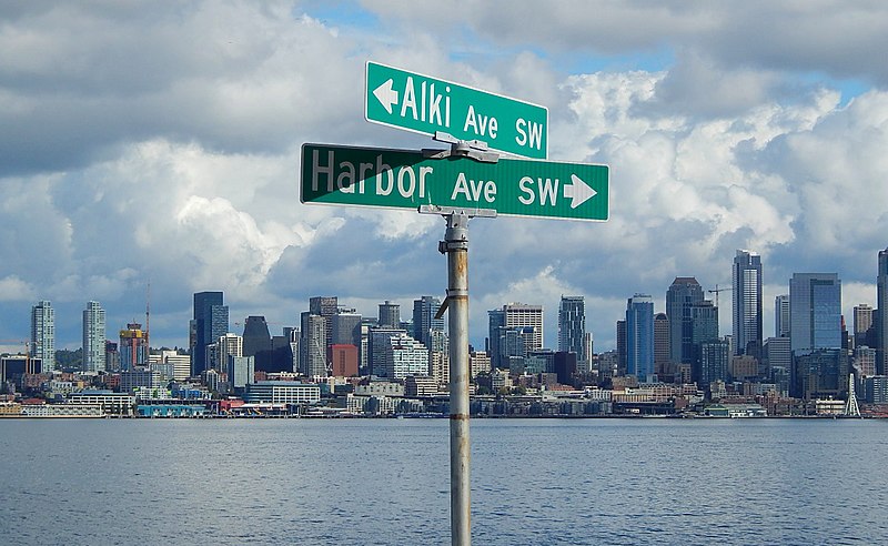
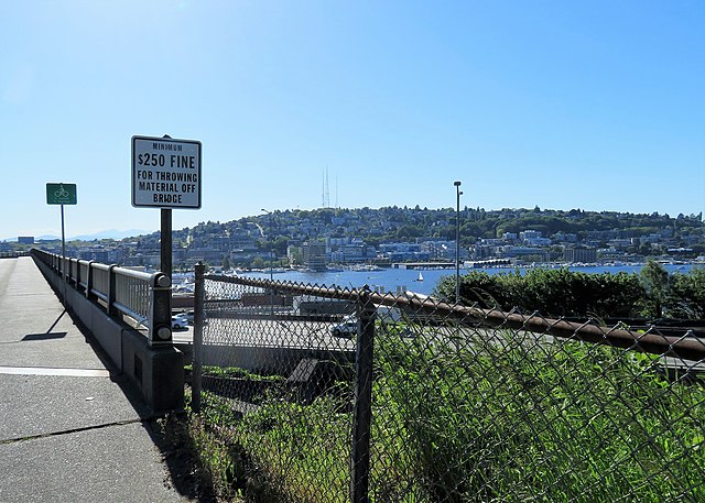
Like Harbor Avenue SW, Beach Drive SW was once part of Alki Avenue SW. It became Beach Drive sometime between 1912 and 1920. In contrast to Alki and Harbor Avenues, most of Beach Drive’s beaches are private, though there is a long public stretch at the Emma Schmitz Memorial Outlook, as well as Lowman Beach Park at the south end.
Born and raised in Seattle, Benjamin Donguk Lukoff had his interest in local history kindled at the age of six, when his father bought him settler granddaughter Sophie Frye Bass’s Pig-Tail Days in Old Seattle at the gift shop of the Museum of History and Industry. He studied English, Russian, and linguistics at the University of Washington, and went on to earn his master’s in English linguistics from University College London. His book of rephotography, Seattle Then and Now, was published in 2010. An updated version came out in 2015.
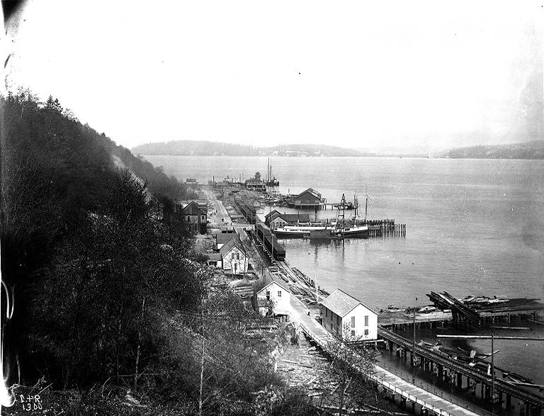
As noted in Alaskan Way, Harbor Avenue SW was once part of Railroad Avenue. When the Elliott Bay tidelands were platted in 1895, Railroad Avenue stretched from (using current landmarks) the Magnolia Bridge along the waterfront to the Industrial District, then across Harbor Island to West Seattle, ending southwest of Duwamish Head. In 1907 the West Seattle portion was renamed Alki Avenue, and sometime between 1912 and 1920 it was given its current name.
Looking northwest up what is now Harbor Avenue SW toward Duwamish Head, April 1902
Today, Harbor Avenue SW begins at SW Avalon Way and SW Spokane Street at the west end of the West Seattle Bridge and goes 1¾ miles northwest to Duwamish Head, where it becomes Alki Avenue SW.
Born and raised in Seattle, Benjamin Donguk Lukoff had his interest in local history kindled at the age of six, when his father bought him settler granddaughter Sophie Frye Bass’s Pig-Tail Days in Old Seattle at the gift shop of the Museum of History and Industry. He studied English, Russian, and linguistics at the University of Washington, and went on to earn his master’s in English linguistics from University College London. His book of rephotography, Seattle Then and Now, was published in 2010. An updated version came out in 2015.
Like Queen Anne Avenue N, Queen Anne Boulevard is named for the neighborhood and hill, themselves named for the Queen Anne architectural style popular with builders in the 1880s. Unlike the avenue, though, the boulevard is not one single street, but a scenic loop incorporating many streets (and hence has no directional designation, such as Queen Anne Boulevard W).
The legislation establishing Queen Anne Boulevard was passed in 1907, and construction took place from 1911 to 1916. The Seattle Department of Transportation has had jurisdiction over the streets since 1942; jurisdiction over the landscaping remains with Seattle Parks and Recreation.
The loop is slightly over 3⅔ miles in length; the ordinance gives its route as follows (edited for style and current street names and directional designations, with notes added):
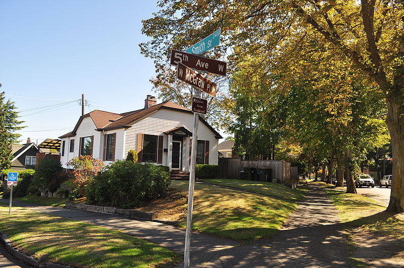
Extending from Prospect Street between Warren Avenue N and 2nd Avenue N, in a northeasterly direction*, to an intersection with Galer Street near Bigelow Avenue N; thence northerly following the general direction of Bigelow Avenue N as nearly as the contours of the ground will permit, to Wheeler Street; thence westerly to Nob Hill Avenue N; thence southerly to McGraw Street; thence westerly to 2nd Avenue N; thence northwesterly to Smith Street†, west of Warren Avenue N; thence westerly along Smith Street to a point east of 1st Avenue W; thence southerly to W McGraw Street and 2nd Avenue West‡; thence westerly to 3rd Avenue W; thence northwesterly to 5th Avenue W and W Smith Street§; thence northerly to W Raye Street; thence westerly to 8th Avenue W; thence northerly to W Armour Street; thence northwesterly to W Fulton Street; thence westerly to 9th Avenue W; thence southwesterly to 10th Avenue W and W Armour Street; thence southerly to W Wheeler Street; thence easterly to 8th Avenue W; thence southerly to W McGraw Street; thence easterly to 7th Avenue W; thence southerly to W Blaine Street; thence westerly to 8th Avenue W; thence southerly to W Lee Street; thence southeasterly to W Highland Drive and 7th Avenue West¶.
* Now the southern extension of Bigelow Avenue N. † Now McGraw Place. ‡ Now the east half of W McGraw Place. § Now the west half of W McGraw Place. ¶ Now 8th Place W.
Notably, there is a gap in the loop; Highland Drive between 7th Avenue W and Warren Avenue N could have made it closed, but this was not done.
“Queen Anne Boulevard, Seattle Historic Landmark” Parks Department sign, 1st Avenue W and W Smith Street, July 2015. Courtesy of the Seattle Municipal Archives, Identifier 178301
Queen Anne Boulevard at night: 8th Place W just north of Marshall Park, July 2015. Note the Wilcox Wall supporting the light fixtures. Courtesy of the Seattle Municipal Archives, Identifier 178303
Born and raised in Seattle, Benjamin Donguk Lukoff had his interest in local history kindled at the age of six, when his father bought him settler granddaughter Sophie Frye Bass’s Pig-Tail Days in Old Seattle at the gift shop of the Museum of History and Industry. He studied English, Russian, and linguistics at the University of Washington, and went on to earn his master’s in English linguistics from University College London. His book of rephotography, Seattle Then and Now, was published in 2010. An updated version came out in 2015.
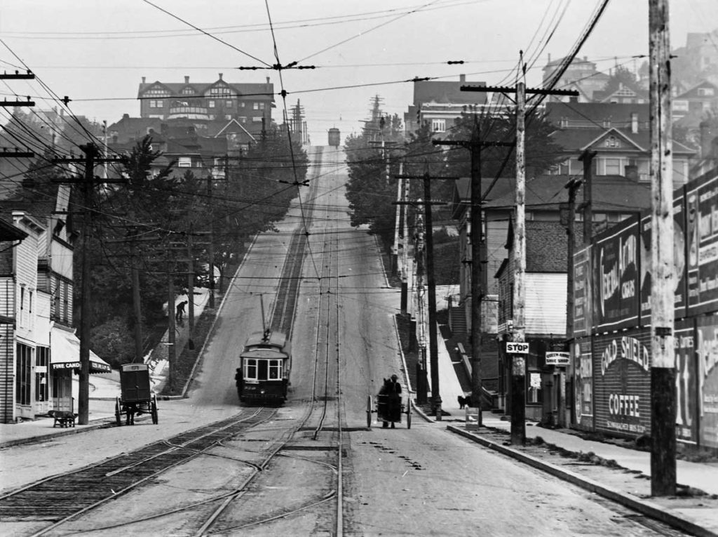
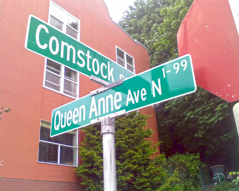
Originally Temperance Street and Villard Avenue, Queen Anne Avenue N was given its current name in 1895 as part of the Great Renaming. It was named after Queen Anne Hill and the Queen Anne neighborhood. Originally called Eden Hill or Galer Hill, they were themselves renamed after the Queen Anne architectural style that became popular in the 1880s.
Looking north up the Counterbalance (Queen Anne Avenue N), 1910
Queen Anne Avenue begins at Western Avenue, less than 100 feet south of Denny Way, and becomes Queen Anne Avenue N as it crosses Denny. From there it goes 2⅕ miles north to Bertona Street and the Ship Canal Trail.
Born and raised in Seattle, Benjamin Donguk Lukoff had his interest in local history kindled at the age of six, when his father bought him settler granddaughter Sophie Frye Bass’s Pig-Tail Days in Old Seattle at the gift shop of the Museum of History and Industry. He studied English, Russian, and linguistics at the University of Washington, and went on to earn his master’s in English linguistics from University College London. His book of rephotography, Seattle Then and Now, was published in 2010. An updated version came out in 2015.
In 1930, Seattle City Light acquired a number of transmission line rights-of-way. The one immediately concerning us approaches the utility’s South Service Center from the southeast. East of Interstate 5, the Chief Sealth Trail runs along the right-of-way from Beacon Hill to Kubota Garden. West of the freeway, a road was built in the late 1960s as part of the South Seattle Redevelopment Project, or South Seattle Industrial Park, as it came to be known. This street was designated Industrial Way in 1969, and runs from Airport Way S in the southeast to 4th Avenue S and Diagonal Avenue S in the northwest, a distance of about ⅓ of a mile.
Aerial view of Industrial District, May 2009. S Industrial Way is the boulevard with the grassy median at center right, leading to the City Light South Service Center. The diagonal street at its end is, appropriately, Diagonal Avenue S, and the arterial it stops at is 4th Avenue S. The Union Pacific Railroad’s Argo Yard is in the upper-left-hand corner, and Airport Way S and Interstate 5 run along the bottom. Photograph by Flickr user J Brew, licensed under Creative Commons Attribution-ShareAlike 2.0 Generic
Born and raised in Seattle, Benjamin Donguk Lukoff had his interest in local history kindled at the age of six, when his father bought him settler granddaughter Sophie Frye Bass’s Pig-Tail Days in Old Seattle at the gift shop of the Museum of History and Industry. He studied English, Russian, and linguistics at the University of Washington, and went on to earn his master’s in English linguistics from University College London. His book of rephotography, Seattle Then and Now, was published in 2010. An updated version came out in 2015.
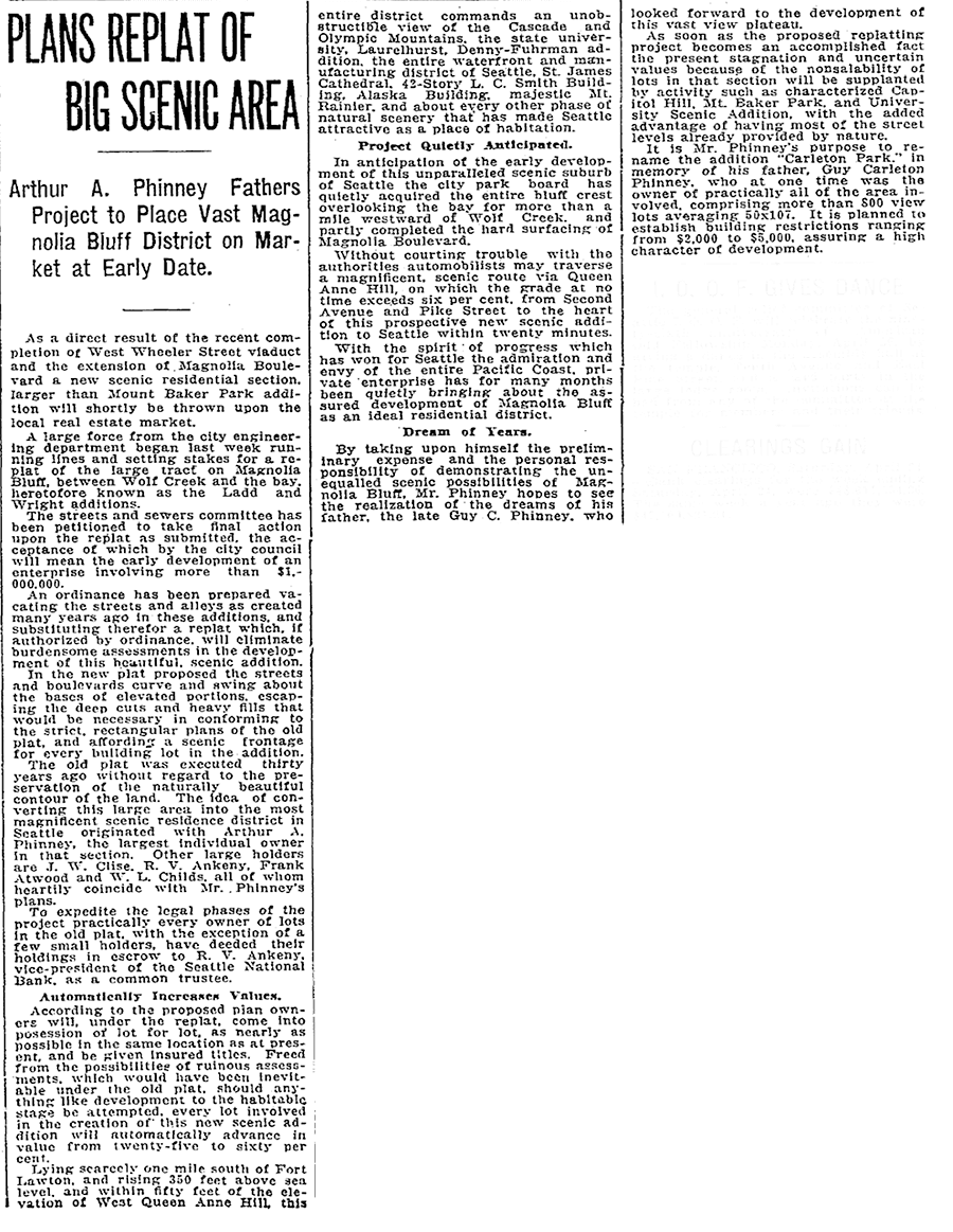
The old plat was executed thirty years ago without regard to the preservation of the naturally beautiful contour of the land.… In the new plat the streets and boulevards curve and swing about the bases of elevated portions, escaping the deep cuts and heavy fills that would be necessary in conforming to the strict, rectangular plans of the old plat, and affording a scenic frontage for every building lot in the addition.… This entire district commands an unobstructible view of the Cascade and Olympic Mountains, the state university, Laurelhurst, Denny-Fuhrman addition, the entire waterfront and manufacturing district of Seattle, St. James Cathedral, 42-story L.C. Smith Building, Alaska Building, majestic Mt. Rainier, and about every other phase of natural scenery that has made Seattle attractive as a place of habitation.
Viewmont Way was obviously named after its view of the mountains, and is of a piece with other Carleton Park streets like Montavista Place, Westmont Way, Eastmont Way, Altavista Place, and the like.
Viewmont Way W begins at the intersection of 34th Avenue W, W Lynn Street, and Montvale Place W in Magnolia Village, and goes ¼ mile southwest to Constance Drive W, where it becomes W Viewmont Way W. The name initially continued about the same distance northwestwards, where the street became 41st Avenue W, but this portion and the rest of 41st Avenue as far north as Fort Lawton (now Discovery Park) were apparently changed at some point to W Viewmont Way. In 1961, the streets became Viewmont Way W and W Viewmont Way W.
Born and raised in Seattle, Benjamin Donguk Lukoff had his interest in local history kindled at the age of six, when his father bought him settler granddaughter Sophie Frye Bass’s Pig-Tail Days in Old Seattle at the gift shop of the Museum of History and Industry. He studied English, Russian, and linguistics at the University of Washington, and went on to earn his master’s in English linguistics from University College London. His book of rephotography, Seattle Then and Now, was published in 2010. An updated version came out in 2015.
[Moore] chose the name because his addition “looked across the water” to Seattle proper like the New York borough of the same name that looks across the East River to Manhattan.
I haven’t been able to find an online source for this assertion, but Dorpat may have been referring to a passage in Roy G. Nielsen’s UniverCity: The Story of the University District in Seattle (1986), which quotes an article in the August 31, 1928, issue of the University Herald in which George F. Cotterill (mayor from 1912–1914) says:
[In 1885], there was no thought of a university and section sixteen was still untouched. J.A. Moore, one of the greatest Seattle real estate promoters of the time, started Brooklyn between 10th Ave. N.E. and the campus. This addition was intended by Mr. Moore to be to Seattle what Brooklyn is to New York.
Today’s Brooklyn Avenue is a block west of Moore’s. Again quoting Paul Dorpat:
None of James Moore’s street names survive. His Tremont Avenue became 15th Avenue. One block west he named University Way — the District’s future “Main Street” — Columbus Avenue. He called the future Brooklyn Avenue, “Broadway,” and this was Moore’s intended “Main Street.” He called 12th Avenue “Brooklyn.”
Brooklyn Avenue NE begins at NE Boat Street just north of Fritz Hedges Waterway Park and goes 1¾ miles north through the University District and Roosevelt neighborhood to NE 66th Street at Roosevelt High School. It resumes at NE 70th Street and goes just short of 300 feet to Froula Playground and the Roosevelt Reservoir. There is another segment between NE 75th Street and NE 77th Street and a final one between NE 80th Street and NE 82nd Street by Maple Leaf Reservoir Park.
Born and raised in Seattle, Benjamin Donguk Lukoff had his interest in local history kindled at the age of six, when his father bought him settler granddaughter Sophie Frye Bass’s Pig-Tail Days in Old Seattle at the gift shop of the Museum of History and Industry. He studied English, Russian, and linguistics at the University of Washington, and went on to earn his master’s in English linguistics from University College London. His book of rephotography, Seattle Then and Now, was published in 2010. An updated version came out in 2015.
This street appears to have been built sometime between 1908 and 1912. (It was established by ordinance in 1906, but that was legislation, not construction. [It was also originally named Ewing Street, the original name of N 34th Street, which still exists on the Queen Anne side of the Ship Canal.]) When the plat of Denny & Hoyt’s Addition to the City of Seattle, W.T., was filed in 1888, no such street was needed, because there was no canal. Instead, Ross Creek connected Lake Union to Salmon Bay. However, as work on the Lake Washington Ship Canal progressed, the Fremont Cut came into being, and it must have been felt a street paralleling the canal to the north was needed, since the original plat took no notice of the creek or any future canal route. (One to the south was needed, too, which is why Nickerson Street was extended from 3rd Avenue W to 4th Avenue N, at the southern end of the Fremont Bridge.)
Why, then, is Canal Street so short — not quite ⅓ of a mile from N 34th Street and Phinney Avenue N in the east to 2nd Avenue NW in the west?
As it turns out, even though Canal Street was to run to what was then the boundary between the cities of Seattle and Ballard at 8th Avenue NW, shortly after Seattle annexed Ballard in 1907 another street was laid out parallel to the canal connecting Fremont to the new neighborhood of Ballard: Leary Way NW (then simply Leary Avenue, all the way from Market Street to Fremont Avenue). Leary became the main arterial, and in 1951 NW Canal Street was vacated between 3rd Avenue NW and 8th Avenue NW, reducing it to its present length. (Until 2016, there was a slight discontinuity in the vicinity of 1st Avenue NW and N 35th Street where the built street deviated from its right-of-way, making it even shorter.)
So this isn’t quite the same as our trio of S Front Street, S River Street, and S Riverside Drive literally being cut short by the rechanneling of the Duwamish River into the Duwamish Waterway — more one of Canal Street being supplanted by Leary Way and becoming more valuable to the city as industrial land than as roadway.
Born and raised in Seattle, Benjamin Donguk Lukoff had his interest in local history kindled at the age of six, when his father bought him settler granddaughter Sophie Frye Bass’s Pig-Tail Days in Old Seattle at the gift shop of the Museum of History and Industry. He studied English, Russian, and linguistics at the University of Washington, and went on to earn his master’s in English linguistics from University College London. His book of rephotography, Seattle Then and Now, was published in 2010. An updated version came out in 2015.
As you might expect, this street is so named because it runs along the west bank of the Duwamish Waterway. However, it only does so for about ⅖ of a mile, from S Webster Street east of 5th Avenue S to a dead end on the river just north of a path to t̓ałt̓ałucid Park and Shoreline Habitat (formerly the 8th Avenue S street end, just north of S Portland Street). It is by no means a prominent street, contrary to what such a name usually implies (Los Angeles, Manhattan, Ottawa, Spokane). In this way it is similar to Seattle’s S Front Street and S River Street. Why is this?
Also as you might expect, it’s for the same reason Front and River Streets are relatively unimportant: the rechanneling of the Duwamish River that started in 1913. Originally Duwamish Avenue in the 1891 plat of River Park, as seen in the image below, Riverside Drive used to curve around a bend in the river. When the river was straightened, the road was cut off right in the middle and became a Riverside Drive to nowhere.
Portion of River Park addition showing Duwamish Avenue (now Riverside Drive)
Born and raised in Seattle, Benjamin Donguk Lukoff had his interest in local history kindled at the age of six, when his father bought him settler granddaughter Sophie Frye Bass’s Pig-Tail Days in Old Seattle at the gift shop of the Museum of History and Industry. He studied English, Russian, and linguistics at the University of Washington, and went on to earn his master’s in English linguistics from University College London. His book of rephotography, Seattle Then and Now, was published in 2010. An updated version came out in 2015.
Like most streets and walkways on the University of Washington campus, Pend Oreille Road NE is named after a Washington county — in this case, Pend Oreille County, which is located in the northeast corner of the state, bordering both Canada and Idaho. The county itself is named for the Pend d’Oreilles, an indigenous people of Eastern Washington, Idaho, and Western Montana.
It struck me as I was writing this post that I don’t know the history of how or when this decision was reached. I will look into this — if anyone has any insight, please let me know!
Pend Oreille Road NE is the east entrance to the university campus. It begins at 25th Avenue NE and NE 44th Street by University Village and goes ⅓ of a mile up the hill to E Stevens Way NE between Clark Hall, Communications Building, and Padelford Hall.
Born and raised in Seattle, Benjamin Donguk Lukoff had his interest in local history kindled at the age of six, when his father bought him settler granddaughter Sophie Frye Bass’s Pig-Tail Days in Old Seattle at the gift shop of the Museum of History and Industry. He studied English, Russian, and linguistics at the University of Washington, and went on to earn his master’s in English linguistics from University College London. His book of rephotography, Seattle Then and Now, was published in 2010. An updated version came out in 2015.
This street, created in 1906 as part of the Lake Shore View Addition to Seattle, begins in the north at NE 105th Street and Exeter Avenue NE, and curves south for a mile along the Burke-Gilman Trail, which parallels the Lake Washington shoreline, to a dead end at the north boundary of Matthews Beach Park. Unlike most, though not all, boulevards in Seattle, this one is not one of the Olmsted boulevards designed by John Charles Olmsted in 1903.
Born and raised in Seattle, Benjamin Donguk Lukoff had his interest in local history kindled at the age of six, when his father bought him settler granddaughter Sophie Frye Bass’s Pig-Tail Days in Old Seattle at the gift shop of the Museum of History and Industry. He studied English, Russian, and linguistics at the University of Washington, and went on to earn his master’s in English linguistics from University College London. His book of rephotography, Seattle Then and Now, was published in 2010. An updated version came out in 2015.
This short street in Seattle’s Windermere neighborhood runs from 60th Avenue NE and NE 55th Street in the southwest to 63rd Avenue NE and NE 57th Street in the northeast. It was likely named after Lochkelden, the mansion built in 1907 for Rolland Herschel Denny (1851–1939) and his wife, Alice Martha Kellogg Denny (1857–1940). Rolland was just six weeks old when the Denny Party landed at Alki Point in November 1851. Lochkelden — owned since 1974 by Sun Myung Moon’s Unification Church — was itself named for Lake Washington, of which it has a commanding view (loch being Scottish for ‘lake’) and its owners: Kellogg and Denny.
Note added March 14, 2024: It appears, per Clay Eals at PaulDorpat.com, that the church put Lockhelden on the market in 2022 and it just sold for $6 million. The purchasers are developers, and property owned by religious organizations cannot get landmark protection against the owner’s will, so the mansion’s days are almost certainly numbered.
Born and raised in Seattle, Benjamin Donguk Lukoff had his interest in local history kindled at the age of six, when his father bought him settler granddaughter Sophie Frye Bass’s Pig-Tail Days in Old Seattle at the gift shop of the Museum of History and Industry. He studied English, Russian, and linguistics at the University of Washington, and went on to earn his master’s in English linguistics from University College London. His book of rephotography, Seattle Then and Now, was published in 2010. An updated version came out in 2015.
This street, which originates along with the rest of the heart of Ballard in the 1889 plat of Gilman Park, was named for šilšul, a village of the shill-shohl-AHBSHpeople along what is today known as Salmon Bay. Meaning ‘tucked away inside’ in the Lushootseed language, it is one of two remaining Native place names in Seattle, the other being Licton Springs (liq’təd). (Note added May 20, 2023: I should have written that it is one of two Native place names in Seattle that remain in common use. The Duwamish are still here, and so are their names.)
Why, then, is the Shilshole Bay name applied to the body of water west of the Ballard Locks? Shouldn’t Shilshole Avenue, Shilshole Bay, and šilšul all be in the same location? According to Edmond Stephen Meany’s 1923 Origin of Washington Geographic Names, citing early settler Arthur A. Denny’s 1888 Pioneer Days on Puget Sound,
In December, 1852, Arthur A. Denny, knew the bay as “Shilshole.” It was later changed to Salmon Bay because it was thought to be frequented by Salmon.
Today, Shilshole Avenue NW begins at 14th Avenue NW in the east and goes ⅘ of a mile northwest to 24th Avenue NW, just short of NW Market Street.
Born and raised in Seattle, Benjamin Donguk Lukoff had his interest in local history kindled at the age of six, when his father bought him settler granddaughter Sophie Frye Bass’s Pig-Tail Days in Old Seattle at the gift shop of the Museum of History and Industry. He studied English, Russian, and linguistics at the University of Washington, and went on to earn his master’s in English linguistics from University College London. His book of rephotography, Seattle Then and Now, was published in 2010. An updated version came out in 2015.
This winding, semicircular street runs almost ⁹⁄₁₀ of a mile from 15th Avenue NW and NW 100th Street in the east to Triton Drive NW, NW Neptune Place, and NW 100th Street in the west, descending 300 feet to Puget Sound along the way. Named after the Blue Ridge community, it was established in 1930 as part of the plat of Blue Ridge, an Addition to King County, Washington (rather than to Seattle, as the far northwestern section of the city wouldn’t be annexed until 1953).
No property in said Addition shall at any time be sold, conveyed, rented, or leased in whole or in part to any person or persons not of the White or Caucasian race. No person other than one of the White or Caucasian race shall be permitted to occupy any property in said addition or portion thereof or building thereon except a domestic servant actually employed by a person of the White or Caucasian race where the latter is an occupant of such property.
Uniquely, as they note, the restrictions on membership in the Blue Ridge Club, established in 1941 and forerunner of today’s homeowner association, were slightly different:
No Asiatic, Negro or any person born in the Turkish Empire, nor lineal descendant of such person shall be eligible for membership in the Club.
They speculate this restriction on Ottoman citizens and descendants thereof was aimed at Sephardic Jews (Seattle is said to have the third largest population in the country), although if that is the case, I wonder why the restriction wasn’t against all Jews, as was done in Broadmoor and the Sand Point Country Club. At any rate, it would seem to have affected not only Sephardim but Arabs, Levantines, and North Africans in general. These restrictions were finally lifted in 1989, decades after they became unenforceable.
Blue Ridge says that “The development of the Blue Ridge community and the government-engineered policies of segregation brings some controversy to the early days of the neighborhood. However, today Blue Ridge is diverse and welcoming to anyone wanting to share in all that it has to offer.” As the interactive map on the Seattle Civil Rights & Labor History Project page on Blue Ridge shows, though, the covenants had the desired effect — the neighborhood is still around 81% white, 12% Asian… and just 0.5% Black.
As far as being an “exclusive” neighborhood goes, Blue Ridge is more like Windermere than the above-mentioned Broadmoor and Sand Point Country Club; it features a private waterfront park, but all the streets are public, and there are even two very small public parks (Blue Ridge Circle and Blue Ridge Places) plus the wooded Mary Avenue Trail to the southern boundary of Carkeek Park.
Ten or so years ago I saw a Private Property sign at the trailhead, put up by the Blue Ridge Club, but it was gone the next time I visited — I can’t remember if I complained or someone else did. (The woods are private, but the trail is Mary Avenue NW right-of-way.) This wasn’t in the original plat, but according to an old Flickr chat I had with Andreas “Severinus” Breuer, “there was apparently a WPA project approved to install a 30′-wide gravel road between 100th and 110th (apparently now NW Carkeek Park Road).… I imagine the ravine would look quite different if a 30′ gravel road had been put in, so presumably this plan wasn’t carried out. But a 1940 engineering map shows a surveyed ROW from 105th to the Carkeek border, and in Carkeek there seems to be a route that follows the WPA route (Clay Pit Trail > Hillside Trail > Brick Road Trail > Road). Perhaps the trail that exists today was made by the original surveyors or by WPA men?”
Born and raised in Seattle, Benjamin Donguk Lukoff had his interest in local history kindled at the age of six, when his father bought him settler granddaughter Sophie Frye Bass’s Pig-Tail Days in Old Seattle at the gift shop of the Museum of History and Industry. He studied English, Russian, and linguistics at the University of Washington, and went on to earn his master’s in English linguistics from University College London. His book of rephotography, Seattle Then and Now, was published in 2010. An updated version came out in 2015.
This short street runs just over 750 feet from Triton Drive NW in the west to NE 98th Street in the east, just west of 24th Avenue NW. It was established in 1926 as part of North Beach, an Addition to the City of Seattle; at the time, it extended farther south, but that section is now 26th Avenue NW. The beach being referred to is on Puget Sound, across the BNSF Railway tracks from what is now NW Esplanade.
Although it bears the neighborhood’s name, houses along North Beach Drive are actually only eligible for associate, not full, membership in the North Beach Club, as the community boundary map shows. This is because the club, which originated in 1927 as the Golden View Improvement Club, was formed by and for residents of the Golden View and Golden View Division № 2 subdivisions, platted in 1924 and 1926, respectively. (According to state records, the GVIC was administratively dissolved in 1982 and merged into the North Beach Club [founded 1990] in 2006. [No word on what entity managed affairs from 1982 to 1990.]) In 1930, the club took over responsibility for the subdivisions’ water system from the developer, who as part of the deal deeded 1,500 feet of Puget Sound beach to the organization. It is this private beach, accessible via a short path from NW Esplanade at 28th Avenue NW, that is the North Beach Club’s primary raison d’être today, the water system having been hooked into the city supply long ago. Today’s associate members are the “descendants” of those who were interested in the Golden View additions’ water system 91 years ago but lived outside the subdivision boundaries — including residents of NW North Beach Drive.
Born and raised in Seattle, Benjamin Donguk Lukoff had his interest in local history kindled at the age of six, when his father bought him settler granddaughter Sophie Frye Bass’s Pig-Tail Days in Old Seattle at the gift shop of the Museum of History and Industry. He studied English, Russian, and linguistics at the University of Washington, and went on to earn his master’s in English linguistics from University College London. His book of rephotography, Seattle Then and Now, was published in 2010. An updated version came out in 2015.
This street runs just shy of a mile through the gated Broadmoor neighborhood and golf course from its south entrance at E Madison Street at 36th Avenue E to its north entrance at E Foster Island Road.
An article in the May 18, 1924, issue of The Seattle Times noted that “[Broadmoor’s] roadways will not be public streets as in other residential sections of the city,” calling this “one of the unmatched features of this community,” and adds that “certain restrictions have been named both as to the class of residences that may be constructed as well as to those who will be admitted to membership.” The entire community being private was a first for Seattle, and in fact has never been repeated — the Sand Point Country Club was also established in the late 1920s, but was in unincorporated King County at the time and wasn’t annexed until 1953, whereas Windermere, established within Seattle city limits around the same time, was in fact platted as a traditional neighborhood, albeit one with private amenities.
Speaking of those “certain restrictions,” by the way, it seems that even in the 1920s one could not say openly in the press what one really meant. But Broadmoor deeds and their racial restrictive covenants are public record:
No part of said property hereby conveyed shall ever be used or occupied by any Hebrew or by any person of the Ethiopian, Malay or any Asiatic Race, and the party of the second part, his heirs, personal representatives or assigns, shall never place any such person in the possession or occupancy of said property or any part thereof, nor permit the said property, or any part thereof, ever to be used or occupied by any such person, excepting only employees in the domestic service on the premises of persons qualified hereunder as occupants and users and residing on the premises.
Broadmoor: Restricted Residential Park With Golf Course, 1924. Courtesy of the Seattle Municipal Archives, Identifier 1423.
The origin of the Broadmoor name is not entirely clear. Did it have anything to do with the Broadmoor Golf Club in Colorado Springs, which opened in 1918? Or with the moors of Scotland, home of modern golf? The above-mentioned Seattle Times article, which is so similar to one in the Seattle Post-Intelligencer it must have been based on a Puget Mill Company press release, doesn’t say. (My friend, local historian Joe Mabel, notes the best-known Broadmoor in the U.K. is actually a high-security psychiatric hospital founded in 1863.) It may just be that “Broadmoor” was considered to be “elegant.” Perhaps the answer lies somewhere in the personal papers of Edwin Gardner Ames, Puget Mill president and one of the developers of Broadmoor along with Grosvenor Folsom and George W. Johnson.
Born and raised in Seattle, Benjamin Donguk Lukoff had his interest in local history kindled at the age of six, when his father bought him settler granddaughter Sophie Frye Bass’s Pig-Tail Days in Old Seattle at the gift shop of the Museum of History and Industry. He studied English, Russian, and linguistics at the University of Washington, and went on to earn his master’s in English linguistics from University College London. His book of rephotography, Seattle Then and Now, was published in 2010. An updated version came out in 2015.
This semicircular street in Seattle’s Windermere neighborhood runs just over a mile from Sand Point Way NE between NE 55th Street and NE 58th Street in the west to just north of NE 61st Street in the east, at the southern end of Magnuson Park. The street and neighborhood itself were named after Windermere, the largest lake in England.
Plat of Windermere, an Addition to the City of Seattle, 1937. Courtesy of the Seattle Municipal Archives, Identifier 1628.
Unfortunately, as with far too many Seattle subdivisions, Windermere deeds came with racial restrictive covenants. The relevant part of this deed reads as follows:
Said property shall not be conveyed, sold, rented, or otherwise disposed of, in whole or in part, to, or be occupied by, any person or persons except of a white and Gentile race, except, however, in the case of a servant actually employed by the lawful owner or occupant thereof.
Notably, although membership in the Windermere Corporation does come with access to the private Windermere Park and Beach Club, all streets in the neighborhood are public — it is a gated community only in spirit.
Born and raised in Seattle, Benjamin Donguk Lukoff had his interest in local history kindled at the age of six, when his father bought him settler granddaughter Sophie Frye Bass’s Pig-Tail Days in Old Seattle at the gift shop of the Museum of History and Industry. He studied English, Russian, and linguistics at the University of Washington, and went on to earn his master’s in English linguistics from University College London. His book of rephotography, Seattle Then and Now, was published in 2010. An updated version came out in 2015.
Lakeview Boulevard E, which originated in David and Louisa Denny’s 1886 East Park Addition to the City of Seattle, is named for its view of Lake Union to the west. For a time part of the Pacific Highway (now routed onto Aurora Avenue N), it begins today at an overpass over Interstate 5 at Eastlake Avenue E and Mercer Street and goes a mile north to Boylston Avenue E and E Newton Street.
Interstate 5 blocks the view of the lake from much of the northern section of the street, but the southern section’s view is still more or less intact.
Born and raised in Seattle, Benjamin Donguk Lukoff had his interest in local history kindled at the age of six, when his father bought him settler granddaughter Sophie Frye Bass’s Pig-Tail Days in Old Seattle at the gift shop of the Museum of History and Industry. He studied English, Russian, and linguistics at the University of Washington, and went on to earn his master’s in English linguistics from University College London. His book of rephotography, Seattle Then and Now, was published in 2010. An updated version came out in 2015.
Forming a trio with Eastlake Avenue and Northlake Way, Westlake Avenue is so named for running along the western shore of Lake Union. Beginning today at Stewart Street between 5th Avenue and 6th Avenue, just north of McGraw Square, it runs 2½ miles north to 4th Avenue N between Nickerson Street and Florentia Street — the south end of the Fremont Bridge.
Westlake Avenue once started a couple of blocks to the south, at 4th Avenue and Pike Street, and based on the quarter section map, it appears that its former route through Westlake Park between Pike Street and Pine Street is still public right-of-way as opposed to park land. (The portion between Pine Street and Olive Way was vacated in 1986 to make way for the Westlake Center mall, which opened in 1988, and the portion between Olive Way and Stewart Street was closed in 2010 to allow for the expansion of McGraw Square.)
Westlake was extended south to 4th and Pike from Denny Way in 1902 (one former mayor has called for that extension to be closed to cars); the original Westlake Avenue (now, properly, Westlake Avenue N) was created in 1895 as part of the Great Renaming ordinance, Section 5 of which reads
That the names of Rollin Street, Lake Union Boulevard and Lake Avenue from Depot Street [changed by the same ordinance to Denny Way] to Florentia Street, be and the same are hereby changed to Westlake Avenue.
Rollin Street, the southernmost portion, was named for Rolland Herschel Denny (1851–1939), the youngest member of the Denny Party at just six weeks old. In its honor, an apartment complex that opened at the corner of Westlake and Denny in 2008 is named Rollin Street Flats.
Having covered Northlake, Eastlake, and Westlake so far, one might ask: why is there no Southlake?
There does appear to have been a Southlake Avenue for a time — 1909 to 1924 or so, based on the last mention of it I could find in Seattle newspapers, an article in the August 8, 1924, edition of The Seattle Times on a car crash that had taken place a number of weeks earlier. Now the northern section of Fairview Avenue N, it extended from the intersection of Valley Street northwest to E Galer Street and Eastlake Avenue E, “thus eliminating the present grade on Eastlake for University traffic” in the words of a real estate advertisement in the August 23, 1914, edition of the Seattle Post-Intelligencer. But why the Southlake name disappeared seems clear: once it was decided to extend the Fairview name along the shore lands, there was no other appropriate road to carry it. The northern and eastern shores of Lake Union are just shy of 2 miles long each, but since the lake is shaped like a ? (and, surprisingly, like a uterus if Portage Bay is included) there is hardly any southern shore to speak of — only about ¼ mile.
As for the neighborhood name, I’m not sure why South Lake Union came to be used instead of Southlake. Perhaps it’s as simple as the lack of a similarly named street to “anchor” the neighborhood.
Born and raised in Seattle, Benjamin Donguk Lukoff had his interest in local history kindled at the age of six, when his father bought him settler granddaughter Sophie Frye Bass’s Pig-Tail Days in Old Seattle at the gift shop of the Museum of History and Industry. He studied English, Russian, and linguistics at the University of Washington, and went on to earn his master’s in English linguistics from University College London. His book of rephotography, Seattle Then and Now, was published in 2010. An updated version came out in 2015.


.jpg)
.jpg)
.jpg)