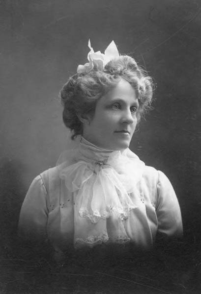
This street is named for Margaret Lenora Denny (1847–1915), daughter of Arthur Armstrong Denny and Mary Ann Boren Denny. She, like Virginia Bell (namesake of Virginia Street) was just four years old when her family, as part of the Denny Party, settled at Alki Point in 1851. She was killed in a car crash that also took the life of Thomas W. Prosch (Prosch Avenue W); his wife, Virginia; and artist Harriet Foster Beecher.
Margaret Lenora Denny, circa 1900
Established as part of A.A. Denny’s 6th Addition to the City of Seattle in 1873, it begins at Alaskan Way as an (temporarily closed as of this writing) elevator and pedestrian bridge over the BNSF Railway tracks. The street proper begins just west of where Elliott Avenue ends at Western Avenue. From there it is just shy of ¾ of a mile to its end at Denny Way and Boren Avenue.
Note added October 10, 2023: Lenora Street now begins a block further to the southeast, at Elliott Way.
Born and raised in Seattle, Benjamin Donguk Lukoff had his interest in local history kindled at the age of six, when his father bought him settler granddaughter Sophie Frye Bass’s Pig-Tail Days in Old Seattle at the gift shop of the Museum of History and Industry. He studied English, Russian, and linguistics at the University of Washington, and went on to earn his master’s in English linguistics from University College London. His book of rephotography, Seattle Then and Now, was published in 2010. An updated version came out in 2015.
This street is named for Mary Virginia Bell Hall (1847–1931), daughter of William Nathaniel Bell and Sarah Ann Peter Bell. Belltown and Bell Street were named for her father, Olive Way for her sister, and Stewart Street for her brother-in-law. She was just four years old when her family, as part of the Denny Party, settled at Alki Point in 1851.
Born and raised in Seattle, Benjamin Donguk Lukoff had his interest in local history kindled at the age of six, when his father bought him settler granddaughter Sophie Frye Bass’s Pig-Tail Days in Old Seattle at the gift shop of the Museum of History and Industry. He studied English, Russian, and linguistics at the University of Washington, and went on to earn his master’s in English linguistics from University College London. His book of rephotography, Seattle Then and Now, was published in 2010. An updated version came out in 2015.
This street is named for Olive Julia Bell Stewart (1846–1921), daughter of William Nathaniel Bell and Sarah Ann Peter Bell. Belltown and Bell Street were named for her father, Virginia Street for her sister, and Stewart Street for her husband, Joseph. She was one of the younger members of the Denny Party, being five years old when they initially settled at Alki Point in 1851.
On September 3, 1920, The Seattle Times reported that:
Extension of Olive Street, by the establishment of a diagonal thoroughfare to be known as Olive Way, running from the intersection of Olive Street in a northeasterly direction to Boylston Avenue North and East Denny Way, is provided in an ordinance completed yesterday afternoon by the city engineer’s office…. The purpose of the whole improvement is to afford an east and west arterial highway, leading from the business district into the residence section of the city, supplementary to Pike Street and Pine Street.
According to the Seattle Post-Intelligencer’s June 24, 1923, issue, it “formally opened to traffic yesterday… a public improvement for which a fight extending over a period of fifteen years was waged,” so this 1920 ordinance was certainly not the first time an improved connection between Downtown and Capitol Hill was proposed. I’m not entirely sure what happened in 1908 the writer might have been referring to, but perhaps it was the Bogue Plan and he was off by a few years?
Portion of plate 7, Baist’s Real Estate Atlas of Seattle (1912), planned route of E Olive Way drawn in pencil. The portion of E Olive St between Melrose and Bellevue Avenues is now E Olive Place.
It appears from the 1921 ordinance establishing the extension that the Olive Way name was originally only applied to the street east of Bellevue Avenue; it wasn’t until 1926 that it was extended west to the street’s origin.
One curiosity about E Olive Way addresses: the block numbers are out of sync with other east–west streets in the area. For example, the block east of Melrose Avenue is the 300 block, east of Bellevue Avenue the 400 block, east of Summit 500, east of Belmont 600, east of Boylston 700, etc. — for other streets. For E Olive Way, east of Melrose is 1300, east of Bellevue 1400 and 1500, east of Summit and Belmont 1600, east of Boylston 1700, etc. — essentially continuing on from Downtown, not starting over at what is now the route of Interstate 5, as the other streets do.
Born and raised in Seattle, Benjamin Donguk Lukoff had his interest in local history kindled at the age of six, when his father bought him settler granddaughter Sophie Frye Bass’s Pig-Tail Days in Old Seattle at the gift shop of the Museum of History and Industry. He studied English, Russian, and linguistics at the University of Washington, and went on to earn his master’s in English linguistics from University College London. His book of rephotography, Seattle Then and Now, was published in 2010. An updated version came out in 2015.
Joseph and Catherine (Henderson) Dunlap arrived in the Puget Sound region in September 1869, having traveled by covered wagon from Iowa. According to family legend, when they arrived in the Puget Sound region, they followed a road over Beacon Hill and sent their son George up a tree to view the land to the south and east. There he spotted a flat valley and Lake Washington. The Dunlaps decided to homestead in that valley, located to the south of the Van Asselt and Mapel families. They claimed 120 acres extending east toward Rainier Beach.
Today, S Henderson Street begins at Seward Park Avenue S, just west of Be’er Sheva Park, and runs ¾ of a mile west to Carkeek Drive S. On the other side of Interstate 5 and the Duwamish River, it runs ⁹⁄₁₀ of a mile through South Park from just east of 14th Avenue S to just west of 2nd Avenue S, the portion over Highway 99/W Marginal Way S being a footbridge. Once in West Seattle, SW Henderson Street runs ⅔ of a mile from 8th Avenue SW, just west of Westcrest Park, to 21st Avenue SW, where the arterial turns into SW Barton Place, and is then a two-block residential street from 22nd Avenue SW to 25th Avenue SW, where it is blocked by the Westwood Village shopping mall. On the other side of the mall, it’s ⅘ of a mile from 28th Avenue SW to SW Barton Street at Fauntleroy Park, and then a final couple of blocks from 43rd Place SW to Fauntleroy Way SW, just north of Washington State Ferries’ Fauntleroy Terminal.
Born and raised in Seattle, Benjamin Donguk Lukoff had his interest in local history kindled at the age of six, when his father bought him settler granddaughter Sophie Frye Bass’s Pig-Tail Days in Old Seattle at the gift shop of the Museum of History and Industry. He studied English, Russian, and linguistics at the University of Washington, and went on to earn his master’s in English linguistics from University College London. His book of rephotography, Seattle Then and Now, was published in 2010. An updated version came out in 2015.
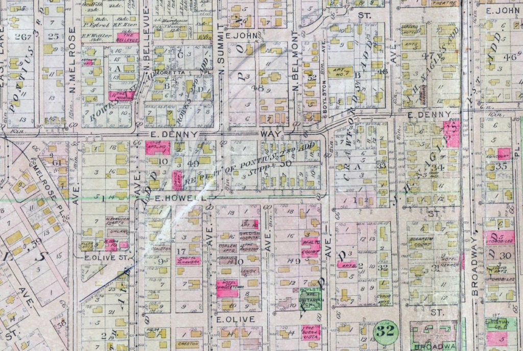
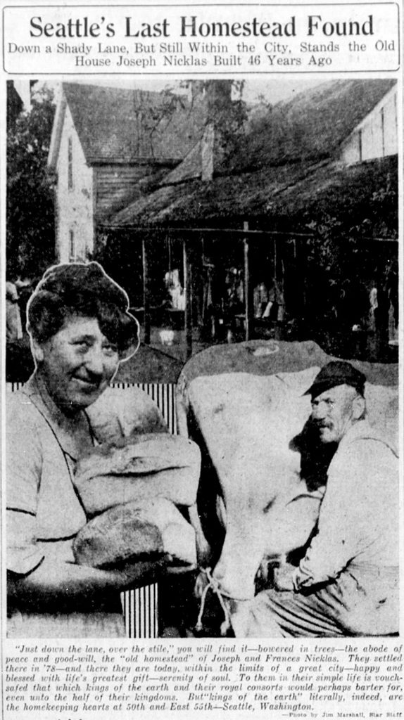
This short street runs just over a tenth of a mile from 50th Avenue NE by St. Bridget Catholic Church in the northwest to NE 50th Street by Villa Academy in the southeast. It was established in 1913 as part of the Montlake Tracts addition by “Magdalena Nicklas, a widow.” Legal advertisements in The Seattle Republican newspaper in 1908 show her husband’s name to have been John Nicklas. Based on this article by Valarie Bunn, this FamilySearch page, this Find a Grave page, plus an item in the November 25, 1941, issue of the Seattle Post-Intelligencer, saying that 20 years earlier “the first woman to homestead on Sand Point, Mrs. Magdalena Nicklas, eighty-two, dies at her home,” we can expand the Nicklases’ biographical information to be Magdalena Kummer, 1839–1921, and Johann “John” Nicklas, 1834–1908, who were farmers in what is now Přimda, Czech Republic, but was then Pfraumberg, Austria–Hungary. They came to the United States in 1867 and to Seattle in 1878, and their land claim covered the 160 acres between what is now NE 45th Street on the south, NE 55th Street on the north, 45th Avenue NE on the west and 55th Avenue NE on the east.
Map of land claims in what is now Laurelhurst, from A History of Laurelhurst by Christine Barrett, published 1981.
Joseph and Frances Nicklas featured in The Seattle Star, June 26, 1924. Joseph was the son of John and Magdalena, and was 17 when the family made their claim in 1878. The caption reads: “Just down the lane, over the stile,” you will find it — bowered in trees — the abode of peace and good-will, the “old homestead” of Joseph and Frances Nicklas. They settled there in ’78 — and there they are today, within the limits of a great city — happy and blessed with life’s greatest gift — serenity of soul. To them in their simple life is vouchsafed that which kings of the earth and their royal consorts would perhaps barter for, even unto the half of their kingdoms. But “kings of the earth” literally, indeed, are the homekeeping hearts at 50th and East 55th — Seattle, Washington. (That location is today where NE 55th Street, Ivanhoe Place NE, 50th Avenue NE, and NE Sand Point Way meet.)
Born and raised in Seattle, Benjamin Donguk Lukoff had his interest in local history kindled at the age of six, when his father bought him settler granddaughter Sophie Frye Bass’s Pig-Tail Days in Old Seattle at the gift shop of the Museum of History and Industry. He studied English, Russian, and linguistics at the University of Washington, and went on to earn his master’s in English linguistics from University College London. His book of rephotography, Seattle Then and Now, was published in 2010. An updated version came out in 2015.
This street runs just over ¼ of a mile from 37th Avenue E in the north, by Lakeview Park, to E Howell Street and 39th Avenue in the south. It was named for George and Otilde Dorffel, who might otherwise be best known for giving Ravenna its name.
In the original 1901 plat of Denny-Blaine-Lake Park, the Dorffel Drive name was given to what is now Madrona Place E, and what is now Dorffel Drive was then 37th Avenue. The change, which took place in 1906, would seem to have been done to eliminate the oddity of 39th Avenue becoming 37th Avenue as it crossed E Howell Street.
Born and raised in Seattle, Benjamin Donguk Lukoff had his interest in local history kindled at the age of six, when his father bought him settler granddaughter Sophie Frye Bass’s Pig-Tail Days in Old Seattle at the gift shop of the Museum of History and Industry. He studied English, Russian, and linguistics at the University of Washington, and went on to earn his master’s in English linguistics from University College London. His book of rephotography, Seattle Then and Now, was published in 2010. An updated version came out in 2015.
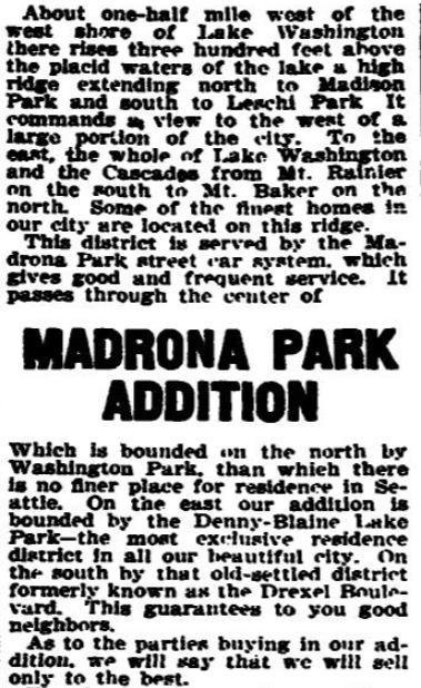
This street runs around 650 feet from 34th Avenue E, just north of E Denny Way, to 37th Avenue East. It was established in 1903 as part of Waddell’s Madrona Park Addition to the City of Seattle by, among others, Albert and Florence M. Waddell.
Advertisement for Madrona Park Addition, The Seattle Times, April 7, 1903
Born and raised in Seattle, Benjamin Donguk Lukoff had his interest in local history kindled at the age of six, when his father bought him settler granddaughter Sophie Frye Bass’s Pig-Tail Days in Old Seattle at the gift shop of the Museum of History and Industry. He studied English, Russian, and linguistics at the University of Washington, and went on to earn his master’s in English linguistics from University College London. His book of rephotography, Seattle Then and Now, was published in 2010. An updated version came out in 2015.
This street lies mostly in Columbia City, where its name originated, and Seward Park, with a few blocks in Beacon Hill and even fewer in West Seattle. It almost reaches Puget Sound at Beach Drive SW, and does reach Andrews Bay of Lake Washington at Lake Washington Boulevard S.
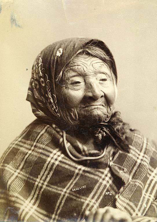
Princess Angeline was born Kikisoblu, the daughter of Si’ahl [siʔaɫ], better known in English as Chief Seattle of the Duwamish and Suquamish Tribes. Her date of birth is unknown; Wikipedia gives it as ca. 1820, whereas this article posted by the Duwamish Tribe, written by elementary school students based on HistoryLink essays, gives it as 1828. She died May 31, 1896.
Princess Angeline received her English name from Catherine Broshears Maynard, wife of David Swinson (“Doc”) Maynard, one of the earliest Seattle settlers. As the HistoryLink Elementary article puts it,
Chief Seattle’s oldest daughter was named Kikisoblu. She became friends with many of Seattle’s founding families. One of her friends was Catherine Maynard. She felt that Kikisoblu should have a name that would let the white settlers know that she was the daughter of a great chief. So she called her Princess Angeline. She thought that name was prettier than the name Kikisoblu.
Photograph of Princess Angeline (Kikisoblu), by Frank La Roche, ca. 1893
Born and raised in Seattle, Benjamin Donguk Lukoff had his interest in local history kindled at the age of six, when his father bought him settler granddaughter Sophie Frye Bass’s Pig-Tail Days in Old Seattle at the gift shop of the Museum of History and Industry. He studied English, Russian, and linguistics at the University of Washington, and went on to earn his master’s in English linguistics from University College London. His book of rephotography, Seattle Then and Now, was published in 2010. An updated version came out in 2015.
Anna Sophia Brygger, the Norwegian immigrant mentioned in NW Brygger Place, is also the namesake of Magnolia’s Brygger Drive W, a short street that runs not quite a tenth of a mile from 34th Avenue W just north of W Government Way to a dead end at Kiwanis Memorial Preserve Park. Many of the streets on the map below were either never built (Northview Place, Albert Street [Alberta is a typo], Byers Place) or were only partially built (Fort Place, 35th Avenue W, 34th Avenue W, and Brygger Drive itself.)
Map of Lawton Heights Addition, Magnolia, 1912 Baist Atlas
Born and raised in Seattle, Benjamin Donguk Lukoff had his interest in local history kindled at the age of six, when his father bought him settler granddaughter Sophie Frye Bass’s Pig-Tail Days in Old Seattle at the gift shop of the Museum of History and Industry. He studied English, Russian, and linguistics at the University of Washington, and went on to earn his master’s in English linguistics from University College London. His book of rephotography, Seattle Then and Now, was published in 2010. An updated version came out in 2015.
One of his blog posts is on NW Brygger Place, which runs around 650 feet from 26th Avenue NW in the east to 28th Avenue NW in the west, just south of NW 60th Street and the Ballard Community Center and Playfield. Its namesake was Anna Sophia Brygger (1853–1940), an immigrant from Norway, who also named Brygger Drive W in Magnolia after herself. Do check it out, along with the rest of his posts.
Map of Brygger’s 1st Home and 2nd Home Additions, Ballard, 1912 Baist’s Real Estate Atlas
Born and raised in Seattle, Benjamin Donguk Lukoff had his interest in local history kindled at the age of six, when his father bought him settler granddaughter Sophie Frye Bass’s Pig-Tail Days in Old Seattle at the gift shop of the Museum of History and Industry. He studied English, Russian, and linguistics at the University of Washington, and went on to earn his master’s in English linguistics from University College London. His book of rephotography, Seattle Then and Now, was published in 2010. An updated version came out in 2015.
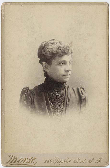
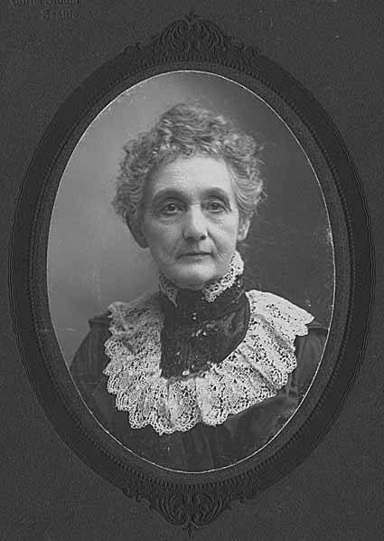
This street runs just over a thousand feet from 10th Avenue W and W Bertona Street in the northwest to 8th Avenue W and W Dravus Street in the southeast. It was named after Susan Conkling Prosch, mother of Thomas Prosch, who filed Prosch’s Queen Anne Addition to the City of Seattle in 1909. (Prosch was a noted local journalist and historian, who didn’t neglect to name Prosch Avenue W after himself.)
Susan Conkling Prosch, 1897
Conkling Place was one of the streets retained when George E. Morford and Gertrude Keen Morford filed their plat of Queen Anne Park in 1926. The Queen Anne Historical Society has an extensive article on the latter subdivision, which was among those in Seattle with all-too-common racial restrictive covenants, in this case excluding Blacks and Asians.
Portion of Prosch’s Queen Anne Addition to the City of Seattle, 1909.
Born and raised in Seattle, Benjamin Donguk Lukoff had his interest in local history kindled at the age of six, when his father bought him settler granddaughter Sophie Frye Bass’s Pig-Tail Days in Old Seattle at the gift shop of the Museum of History and Industry. He studied English, Russian, and linguistics at the University of Washington, and went on to earn his master’s in English linguistics from University College London. His book of rephotography, Seattle Then and Now, was published in 2010. An updated version came out in 2015.
This street, which runs just over 400 feet from 36th Avenue W in the west to 34th Avenue W in the east, was established in 1905 as part of the Lawton Park Addition to Seattle. It was named after Evan Sidebottom McCord, a Seattle lawyer, and his wife, Elizabeth Chenault Bennett McCord, who were among the nine owners of property encompassed by the plat.
Born and raised in Seattle, Benjamin Donguk Lukoff had his interest in local history kindled at the age of six, when his father bought him settler granddaughter Sophie Frye Bass’s Pig-Tail Days in Old Seattle at the gift shop of the Museum of History and Industry. He studied English, Russian, and linguistics at the University of Washington, and went on to earn his master’s in English linguistics from University College London. His book of rephotography, Seattle Then and Now, was published in 2010. An updated version came out in 2015.
I am certainly not the first person to have been interested in, or to blog about, the origins of Seattle street names. One of the historians whose work I’ve been inspired by is Valarie Bunn, who writes Wedgwood in Seattle History (though she does not restrict herself to Wedgwood).
In “The Fischer Farm in Meadowbrook,” from 2013, she writes about August and Wilhelmine Fischer, who came to Seattle from Saxony, Germany, in 1888, and lived here until they died in 1940 and 1941, respectively. In 1922, they established what is now Fischer Place NE as Fischer Street in the plat of Fischer’s Highway Garden Tracts. (“Highway” because of Victory Way [now Lake City Way NE, part of State Route 522] and Pacific Highway [now Ravenna Avenue NE]. The latter lost its Pacific Highway designation to the former that same year, and the designation shifted farther west to what is now Aurora Avenue N a number of years later.) I highly recommend this article and her entire blog.
Born and raised in Seattle, Benjamin Donguk Lukoff had his interest in local history kindled at the age of six, when his father bought him settler granddaughter Sophie Frye Bass’s Pig-Tail Days in Old Seattle at the gift shop of the Museum of History and Industry. He studied English, Russian, and linguistics at the University of Washington, and went on to earn his master’s in English linguistics from University College London. His book of rephotography, Seattle Then and Now, was published in 2010. An updated version came out in 2015.
This street, which runs about 850 feet from NE 63rd Street and 17th Avenue NE in the northwest to 20th Avenue NE in the southeast, was established in 1906 as part of the University Scenic Addition to the City of Seattle, platted by “Naomi A. Young and S.E. Young, her husband.”
Born and raised in Seattle, Benjamin Donguk Lukoff had his interest in local history kindled at the age of six, when his father bought him settler granddaughter Sophie Frye Bass’s Pig-Tail Days in Old Seattle at the gift shop of the Museum of History and Industry. He studied English, Russian, and linguistics at the University of Washington, and went on to earn his master’s in English linguistics from University College London. His book of rephotography, Seattle Then and Now, was published in 2010. An updated version came out in 2015.
Hubbell Place does not appear in the original plat of the area, A.A. Denny’s Broadway Addition to the City of Seattle (1890). When it was established in 1906, it ran only one block, diagonally from 9th Avenue and Union Street to Terry Avenue and Pike Street. Today, however, it begins farther southwest, at 7th Avenue and Spring Street, making its full length just about ⅓ of a mile. (The extension came about because of the construction of Interstate 5 through Downtown — the frontage road on the east side of I-5 connected to the existing Hubbell Place and took its name in 1966.)
The ordinance establishing Hubbell Place “accept[s] a deed of conveyance from George S. McLaren, et ux, and Helen Moore Hubbell” for the land. Et ux is simply Latin for “and wife.” But who was this Helen Hubbell — and, for that matter, who was this George McLaren? Could he be connected with W McLaren Street in Magnolia? (We’ll take that up in a subsequent post.)
Searching for any city ordinance mentioning Hubbell, we come across one “granting permission to Frank B. Hubbell, his heirs and assigns, to lay down, maintain and operate steam and water pipes in and across certain streets and alleys in the City of Seattle for the purpose of conducting steam and water,” passed in 1905. Yet in 1907 it was repealed, and in 1909 a similar ordinance was passed “granting permission to Helen Moore Hubble [italics mine]” to do the same thing. (This franchise expired a number of decades later.) Why might this have happened?
Apparently, Frank B. Hubbell died in 1905, only a few months after he married Helen. As the (Walla Walla) Evening Statesman reported on October 28 of that year, under the headline ‘Seattle capitalist commits suicide’,
Mystery surrounds the suicide by gas last night of Frank B. Hubbell, one of the most prominent real estate men and capitalists in the city. His bride of three months, who occupied separate apartments in a fashionable hotel, discovered him unconscious on the floor of his room this morning. Hubbell was worth half a million dollars and his financial standing was gilt edge. He came from New York a few years ago. Three physicians failed to save his life and he died at 10 this morning. No cause is known for his suiciding. Hubbel [sic] when found had the gas tube in his mouth. Domestic and not financial troubles, are believed to have been the cause. Hubbell had under way some of the greatest public improvements in the history of the city. He has constantly been drawing on eastern capital to accomplish his plans.
Though the Evening Statesman did not believe financial troubles to be the cause of his suicide, The Yakima Heraldreported in 1910, under the headline ‘Closing of Hubbell estate solves suicide mystery’, that he owed $135,000 to Seattle banks, could not pay without putting his fortune at risk, and so decided to kill himself to keep his creditors at bay and preserve his estate for his wife. (That figure corresponds to $3.5 million in today’s money. The Herald went on to say that his total estate amounted to $650,000, or about $16.8 million.)
Frank and Helen Moore Hubbell had one daughter, Helen Frances Hubbell, who apparently died a few months after her 17th birthday in a car accident. She was born in May 1906, 6½ months after the death of her father. The elder Helen died in 1948 at the age of 70.
Born and raised in Seattle, Benjamin Donguk Lukoff had his interest in local history kindled at the age of six, when his father bought him settler granddaughter Sophie Frye Bass’s Pig-Tail Days in Old Seattle at the gift shop of the Museum of History and Industry. He studied English, Russian, and linguistics at the University of Washington, and went on to earn his master’s in English linguistics from University College London. His book of rephotography, Seattle Then and Now, was published in 2010. An updated version came out in 2015.
When I saw that E Jansen Court fell within Jansen’s Addition to the City of Seattle, filed in 1889 by Mary Jansen, I thought “Ah, another case of a landowner naming a street after themselves,” though I did note it was rare to see a single woman’s, and no one else’s, name on such a plat. But once I got a good look at the plat map I realized that, as is often the case, things weren’t quite that simple.
There’s no Jansen Court on this map — instead, John Street keeps its name as it crosses Mulford Street (now 20th Avenue E). So what happened?
In 1954, E John Street — the arterial east of 21st Avenue E — and E Thomas Street — the arterial west of 20th — were connected directly to each other by lopping off a small part of Miller Playfield (creating Miller Triangle in the process). As part of this, a one-way extension of John was built east of 20th, connecting with the arterial just before 21st. But this meant what is now Jansen Court needed a new name (remember, it originally remained John Street after crossing 20th). The powers that be decided to simply name it after Mary Jansen (or her subdivision). So even though she hadn’t named it after herself, 65 years after she filed her plat Jansen finally had her name on a street sign.
Born and raised in Seattle, Benjamin Donguk Lukoff had his interest in local history kindled at the age of six, when his father bought him settler granddaughter Sophie Frye Bass’s Pig-Tail Days in Old Seattle at the gift shop of the Museum of History and Industry. He studied English, Russian, and linguistics at the University of Washington, and went on to earn his master’s in English linguistics from University College London. His book of rephotography, Seattle Then and Now, was published in 2010. An updated version came out in 2015.
This Queen Anne street runs 1½ miles from the meeting of 4th, Dexter, and Westlake Avenues N in the east (at the south end of the Fremont Bridge) to the 15th Avenue W interchange in the west. Some businesses in Fishermen’s Terminal have W Nickerson Street addresses, such as Chinook’s at 1900, but these few blocks of Nickerson are Port of Seattle roads that cannot be accessed directly from the public street.
Nickerson Street was named by Alfred A. Nickerson and Elmyra Nickerson, husband and wife, in their plat of Ross 2nd Addition to the City of Seattle in 1888.
Born and raised in Seattle, Benjamin Donguk Lukoff had his interest in local history kindled at the age of six, when his father bought him settler granddaughter Sophie Frye Bass’s Pig-Tail Days in Old Seattle at the gift shop of the Museum of History and Industry. He studied English, Russian, and linguistics at the University of Washington, and went on to earn his master’s in English linguistics from University College London. His book of rephotography, Seattle Then and Now, was published in 2010. An updated version came out in 2015.
This ⅔-mile–long Magnolia street is named for Mount Constance in the Olympic Mountains. Constance was the older sister of Ellinor Fauntleroy, namesake of Mount Ellinor and Ellinor Drive W. (There are no Magnolia streets named Edward, Arthur, or The Brothers.)
Born and raised in Seattle, Benjamin Donguk Lukoff had his interest in local history kindled at the age of six, when his father bought him settler granddaughter Sophie Frye Bass’s Pig-Tail Days in Old Seattle at the gift shop of the Museum of History and Industry. He studied English, Russian, and linguistics at the University of Washington, and went on to earn his master’s in English linguistics from University College London. His book of rephotography, Seattle Then and Now, was published in 2010. An updated version came out in 2015.
This short street in Magnolia’s Carleton Park subdivision is named for Mount Ellinor in the Olympic Mountains, which was itself named for Ellinor Fauntleroy, the fiancée of George Davidson of the U.S. Coast Survey, who named the peak in 1853. Nearby Constance Drive W is named for Mount Constance, itself named for Ellinor’s older sister.
Most of Magnolia’s streets follow Seattle’s cardinal-direction grid. Here, however, in the southwest corner of the neighborhood, they are laid out to follow the contour of the steep bluff that affords many streets a view of the Olympic Mountains, the Cascade Range, or both.
Born and raised in Seattle, Benjamin Donguk Lukoff had his interest in local history kindled at the age of six, when his father bought him settler granddaughter Sophie Frye Bass’s Pig-Tail Days in Old Seattle at the gift shop of the Museum of History and Industry. He studied English, Russian, and linguistics at the University of Washington, and went on to earn his master’s in English linguistics from University College London. His book of rephotography, Seattle Then and Now, was published in 2010. An updated version came out in 2015.
As of this writing, Seattle’s newest street name is E Barbara Bailey Way — formerly the block of E Denny Way between Broadway and 10th Avenue E.
Barbara Bailey, who died on September 1, 2018, was best known for Bailey/Coy Books, which she founded on Broadway in 1982. As Seattle Mayor Jenny Durkan wrote,
Barbara’s commitment to action made her an early pioneer for LGBTQ+ rights. Her bookstores – B. Bailey Books and Bailey/Coy Books – were nationally beloved independent book stores that regularly brought communities together and hosted renowned authors. They were also safe and welcoming spaces for the LGBTQ+ community, particularly for those just coming out and during the height of anti-LGBTQ+ actions.
Barbara Bailey Way is one of a number of “festival streets” in the city of Seattle.
Born and raised in Seattle, Benjamin Donguk Lukoff had his interest in local history kindled at the age of six, when his father bought him settler granddaughter Sophie Frye Bass’s Pig-Tail Days in Old Seattle at the gift shop of the Museum of History and Industry. He studied English, Russian, and linguistics at the University of Washington, and went on to earn his master’s in English linguistics from University College London. His book of rephotography, Seattle Then and Now, was published in 2010. An updated version came out in 2015.